Disclosure : This site contains affiliate links to products. We may receive a commission for purchases made through these links.
Colombia – Ecuador Nelles
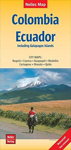
Colombia and Ecuador at 1:2,500,000 on a double-sided map from Nelles on a smaller size sheet offering a convenient format when travelling. Each country is accompanied by street plans of town centres in its main cities. On one side is the northern part of Colombia, extending south beyond Cali to Popayan. Coverage also includes the western tip of Venezuela around Lake Maracaibo and Merida, plus most of Panama. Street plans show city centres of Bogota, Medellin and Cartagena.On the reverse is the remaining part of Columbia and Ecuador, plus the Amazonian part of Peru with Iquitos and coverage south beyond Cajamarca. Street plans show Quito with an enlargement for its Old Town, Guayaquil, Cuenca and Otavalo. Also provided is an inset showing the Galapagos Islands.Topography is shown by relief shading with names of mountain ranges and peaks and spot heights, plus graphics to marshlands and swamp areas. Road network distinguishes between highways in good and poor condition. Railway lines and local airports are included and the map also shows internal administrative boundaries with names of the provinces. National parks and various places of interest are prominently highlighted. The map has latitude and longitude margin ticks at intervals of 2ยฐ and is not indexed.The street plans highlight various places of interest, facilities and public buildings, plus selected tourist accommodation.

Related Products:
 Peru – Ecuador Nelles
 Peru – Colombia – Ecuador – Venezuela Marco Polo Map
 Colombia ITMB
 Ecuador Borch
 Ecuador F&B
 Cuba Nelles
 Quito & Central Ecuador ITMB
 Mexico Nelles
 Colombia F&B
 Admiralty Chart 2799 – Ports on the Coasts of Colombia and Ecuador
 India Nelles
 South America – The Andes Nelles
 Vietnam – Laos – Cambodia Nelles
 Central Asia Nelles
 South Africa – Namibia – Botswana – Zimbabwe Nelles
 New Zealand Nelles
 Malaysia West – Singapore Nelles
 Kenya – Serengeti Nelles
 Namibia – Botswana Nelles
 Myanmar / Burma Nelles
 Philippines – Manila Nelles
 Pakistan Nelles
 Afghanistan Nelles Map
 Ecuador – Galapagos Islands Reise Know-How
 Tunisia Nelles Map
 Cambodia – Angkor Nelles
 Hawaii – Kauai Nelles
Hawaii – The Big Island Nelles
Hawaii – Kauai Nelles
Hawaii – The Big Island Nelles
 Chile – Patagonia Nelles
 India North Nelles
 Hawaii – Oahu – Honolulu Nelles
 China North East Nelles Map
 Ecuador – Galapagos NGS Adventure Map 3403
 Bolivia – Paraguay Nelles
Amazon – Brazil Nelles
Bolivia – Paraguay Nelles
Amazon – Brazil Nelles
 Argentina North – Uruguay Nelles
 Sri Lanka Nelles