Disclosure : This site contains affiliate links to products. We may receive a commission for purchases made through these links.
Colca Canyon – Cotahuasi Canyon
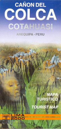
A handy-sized road map of the region, with bilingual notes for tourists. The main map (scale unspecified) is a panoramic oblique-view road map of the wider region northwest of Arequipa, including Colca Canyon, Cotahuasi Canyon, the Majes and Ocoรฑa rivers and Arequipa itself. Hill shading models the general relief to give a 3D effect, with snow capped peaks highlighted. Further detail is limited to main roads, rivers and towns. Accompanying historical and geographical notes in the margin are in Spanish and English.On the reverse are two conventional road maps of Colca Canyon and Cotahuasi Canyon at 1:225,000 clearly indicating roads, trails, general relief, elevations, towns and villages. Symbols denote ruins, hot springs, mines, points of interest, recreational opportunities eg. trekking, river rafting and hang-gliding, and there is and indication of towns which provide accommodation and services for tourists. Further bilingual notes outline the attractions, places to visit, holidays and events. Legend is also in Spanish & English.

Related Products:
 Arequipa Tourist Plan
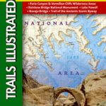
 Grand Canyon North and South Rims – Grand Canyon National Park AZ NGS Trails Illustrated Map 261
 Grand Canyon
 Fish River Canyon & the Richtersveld NGS Adventure Map 3201
 Grand Canyon & Arizona ITMB
 Fish River Canyon
 Grand Canyon: The Complete Guide: Grand Canyon National Park
 Peru Mapa Vial – Mini edition
 Bryce Canyon & Brian Head UT Trail Map
 Grand Canyon National Park East AZ
 Grand Canyon National Park West AZ
 The Grand Canyon Reader
 Moon Arizona & the Grand Canyon (Fifteenth Edition)
 Santander
 Caribbean Islands Explorer
 Spanish English Bilingual Visual Dictionary
Tatev & the Vorotan Canyon Cartisan Hiking Map
Spanish English Bilingual Visual Dictionary
Tatev & the Vorotan Canyon Cartisan Hiking Map
 Black Canyon of the Gunnison NP CO
 Bryce Canyon National Park UT
 Moon California Road Trip (Fourth Edition): San Francisco, Yosemite, Las Vegas, Grand Canyon, Los Angeles & the Pacific Coast
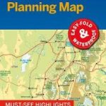
 Grand Canyon National Park Lonely Planet Planning Map
 Peru Borch
 Sequoia – Kings Canyon National Parks CA
 Glen Canyon NRA – Capitol Reef NP UT/AZ
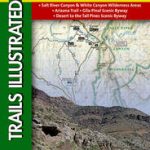 Salt River Canyon – Tonto National Forest AZ
 Moon Grand Canyon
 Zion & Bryce Canyon National Parks Lonely Planet Planning Map
 Peru Mapa Vial
 Huaraz, Peru – Cordillera Blanca & Huayhuash Tourist Map
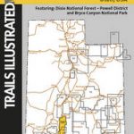 Paunsaugunt Plateau – Mount Dutton – Bryce Canyon UT NGS Trails Illustrated Map 705
 Compass American Guides: Yosemite and Sequoia/Kings Canyon National Parks
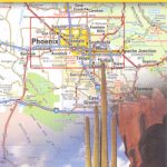 Arizona
 Northern Thailand
 Sycamore Canyon – Verde Valley – Coconino, Kaibab and Prescott National Forests AZ
 North Argentina de Dios Regional Map
 Chihuahua State
Morelos State
Puebla State
Tamaulipas State
Michoacan State
Chihuahua State
Morelos State
Puebla State
Tamaulipas State
Michoacan State