Disclosure : This site contains affiliate links to products. We may receive a commission for purchases made through these links.
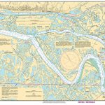
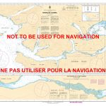
CHS Chart 6435 – Middle Channel, Tununuk Point to Mackenzie Bay Kilometre 1670-1730

The official Canadian charts provide an excellent range of scales for the whole length of Canada`s coastline as well as the Grat Lakes and comply with Safety of Life at Sea (SOLAS) regulations. PLEASE NOTE: Canadian Hydrographic Service charts are ordered on demand, please allow 1-2 weeks for the order to arrive at Stanfords.

Related Products:
 CHS Chart 6452 – Mackenzie River (Kilometre 0-58)
 CHS Chart 6453 – Mackenzie River (Kilometre 58-90)
 CHS Chart 6454 – Mackenzie River (Kilometre 90-147)
 CHS Chart 6455 – Mackenzie River (Kilometre 147-205)
 CHS Chart 6434 – Reindeer Channel, Tununuk Point to Shallow Bay
 CHS Chart 6429 – Kilometre 1580-1645 including East Channel, Inuvik to Kilometre 1645
 CHS Chart 6430 – East Channel, Kilometre 1645-1710
CHS Chart 6432 – Kilometre 1500 to Inuvik East Channel
CHS Chart 6430 – East Channel, Kilometre 1645-1710
CHS Chart 6432 – Kilometre 1500 to Inuvik East Channel
 CHS Chart 6428 – Aklavik Channel to Napoiak Channel including Aklavik Channel to Aklavik Kilometre 1530-1597
CHS Chart 6427 – Point Separation to Aklavik Channel Kilometre 1480-1540
CHS Chart 6428 – Aklavik Channel to Napoiak Channel including Aklavik Channel to Aklavik Kilometre 1530-1597
CHS Chart 6427 – Point Separation to Aklavik Channel Kilometre 1480-1540
 CHS Chart 6431 – East Channel, Lousy Point to Tuktoyaktuk Kilometre 1710-1766
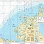 CHS Chart 7662 – Mackenzie Bay
 CHS Chart 6436 – Napoiak Channel, including Schooner and Taylor Channels Kilometre 1590-1650
 CHS Chart 6437 – Peel Channel including Husky Channel and Phillips Channel
 CHS Chart 6441 – West Channel including Anderton Channel, Ministicoog Channel and Moose Channel to Shoalwater Bay
 CHS Chart 7710 – Lambert Channel and Cache Point Channel
CHS Chart 7481 – Foxe Channel
CHS Chart 7710 – Lambert Channel and Cache Point Channel
CHS Chart 7481 – Foxe Channel
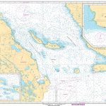
 CHS Chart 3543 – Cordero Channel
 CHS Chart 3537 – Okisollo Channel
 CHS Chart 3891 – Skidegate Channel
 CHS Chart 6438 – Peel River, Mackenzie River to Road Island
 CHS Chart 6408 – Cache Island to Rabbitskin River, Kilometre 233-301
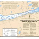 CHS Chart 6409 – Rabbitskin River to Fort Simpson Kilometre 300-330
CHS Chart 6410 – Fort Simpson to Trail River Kilometre 330-390
CHS Chart 6409 – Rabbitskin River to Fort Simpson Kilometre 300-330
CHS Chart 6410 – Fort Simpson to Trail River Kilometre 330-390
 CHS Chart 6411 – Trail River to Camsell Bend Kilometre 390-460
 CHS Chart 6412 – Camsell Bend to McGern Island Kilometre 460-510
CHS Chart 6413 – McGern Island to Wrigley River Kilometre 510-580
CHS Chart 6412 – Camsell Bend to McGern Island Kilometre 460-510
CHS Chart 6413 – McGern Island to Wrigley River Kilometre 510-580
 CHS Chart 6414 – Wrigley River to Three Finger Creek Kilometre 580-650
 CHS Chart 6415 – Three Finger Creek to Saline Island Kilometre 650-730
 CHS Chart 6419 – Norman Wells to Carcajou Ridge Kilometre 910-980
CHS Chart 7485 – Parry Bay to Navy Channel
CHS Chart 6419 – Norman Wells to Carcajou Ridge Kilometre 910-980
CHS Chart 7485 – Parry Bay to Navy Channel
 CHS Chart 7125 – Pike-Resor Channel
 CHS Chart 3475 – Plans in the Stuart Channel
 CHS Chart 6420 – Carcajou Ridge to Hardie Island Kilometre 980-1040
 CHS Chart 7569 – Barrow Strait and Wellington Channel
CHS Chart 7489 – Navy Channel to Longstaff Bluff
CHS Chart 7569 – Barrow Strait and Wellington Channel
CHS Chart 7489 – Navy Channel to Longstaff Bluff
 CHS Chart 3538 – Desolation Sound and Sutil Channel
 CHS Chart 3456 – Halibut Bank to Ballenas Channel
 CHS Chart 3869 – Skidegate Channel to Tian Rock
CHS Chart 6416 – Saline Island to Police Island Kilometre 730-810
CHS Chart 3869 – Skidegate Channel to Tian Rock
CHS Chart 6416 – Saline Island to Police Island Kilometre 730-810