Disclosure : This site contains affiliate links to products. We may receive a commission for purchases made through these links.
China – Mongolia
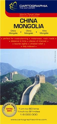
Detailed (but sometimes crowded) road map of China & Mongolia with hill shading, coloring and selected spot heights. A separate inset covers the Hainan Dao Island in China.Six different types of roads plus tracks are indicated with intermediate driving distances on main roads. Also marked are international and disputed boundaries, administrative boundaries, airports and ports, two kinds of railways, cease-fire lines, military demarcation lines and the Great Wall of China.Geographical information include national parks, interesting natural features, thermal springs, salt and intermittent lakes, marshes and swamps. Plus a series of symbols shows tourist points of interest, Buddhist temples and monasteries, mosques and Pagodas.Longitude and latitude lines are drawn at 3ยฐ intervals and the legend is in English, German, French and Hungarian.Printed on paper with an extensive index of place names on the reverse.

Related Products:
 China West Reise Know-How
 China East – North and South Korea Reise Know-How
 China East ITMB
 China ITMB
 China – Mongolia – Taiwan F&B
 China Reise Know-How
 The People`s Republic of China Administrative Map
 Iraq Gizi Map
 China North-West Wall Map
 Iraq Wall Map
 China South Gizi Map
 Mongolia ITMB
 China: Reise Know-How Road Maps
 China South Wall Map
 China West ITMB
 Mongolia Gizi Road Map
 China Central Wall Map
 Mongolia Road Edition Wall Map
 China North-East Wall Map
 China Central Gizi Map
 China North East
 Mongolia Geographical Edition Wall Map
 Mongolia (Geographical Edition)
 China Northeast Gizi Map
 China Gizi Map Geographical Wall Map
 China Northwest Gizi Map
 Botswana F&B
 China NGS Classic Wall Map PAPER
 China: GiziMap Regional Maps
 China South Central
 Lake Baikal Reise Know-How
 Sahara ITMB
 China NGS Classic Wall Map ENCAPSULATED
 China Adventure Map
 China East Adventure Map
 China Administrative Gizi Map
 East Tibet Gecko Map
 Mr Selden`s Map of China: The Spice Trade, a Lost Chart & the South China Sea
 China NGS Executive Wall Map ENCAPSULATED