Disclosure : This site contains affiliate links to products. We may receive a commission for purchases made through these links.
Chigwell Station 1914
Chigwell Station in 1914 in a fascinating series of reproductions of old Ordnance Survey plans in the Alan Godfrey Editions, ideal for anyone interested in the history of their neighbourhood or family. The map covers the area around and to the south and west of Chigwell station. Coverage continues only a little way north, to Grange Court, but to the south-west it stretches along Chigwell Road to Hill House, Turpins Lane and the massive Chigwell Convent (here called Manor House and an orphanage) which is at the foot of the map on the outskirts of Woodford Bridge. The River Roding meanders down the left-hand side of the map. To add interest to this somewhat rural map a directory of Chigwell is on the back, plus a 1915 timetable for the Ilford – Woodford lineAbout the Alan Godfrey Editions of the 25″ OS SeriesSelected towns in Great Britain and Ireland are covered by maps showing the extent of urban development in the last decades of the 19th and early 20th century. The plans have been taken from the Ordnance Survey mapping and reprinted at about 15 inches to one mile (1:4,340). On the reverse most maps have historical notes and many also include extracts from contemporary directories. Most maps cover about one mile (1.6kms) north/south, one and a half miles (2.4kms) across; adjoining sheets can be combined to provide wider coverage.FOR MORE INFORMATION AND A COMPLETE LIST OF ALL AVAILABLE TITLES PLEASE CLICK ON THE SERIES LINK.

Related Products:
 Chigwell Row and Grange Hill 1914
March Station 1900
Finchfield and Wightwick 1914
Wolverhampton Bushbury 1914
Llantwit Major 1914
Chigwell Row and Grange Hill 1914
March Station 1900
Finchfield and Wightwick 1914
Wolverhampton Bushbury 1914
Llantwit Major 1914
 Jesmond 1914
Newcastle & Gateshead 1914 – 18b
Jesmond 1914
Newcastle & Gateshead 1914 – 18b
 London Bridge Station 1872-1893
 Poplar 1914 – 65.3
 Blackheath 1914 – 105.3
 Lewisham 1914 – 119.3
Trimdon Grange 1914
Lewisham 1914 – 119.3
Trimdon Grange 1914
 Snaresbrook 1939
Pwllheli 1914
Snaresbrook 1939
Pwllheli 1914
 Stoke Newington 1914 – 30.3
 Leyton 1914
Stourbridge South and Oldswinford 1914
Leyton 1914
Stourbridge South and Oldswinford 1914
 Shoreditch 1914 – 51.3
Gurnos 1914 – 43.14
Shoreditch 1914 – 51.3
Gurnos 1914 – 43.14
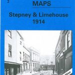 Stepney & Limehouse 1914 – 64.3
The West End 1914 – 61.3
Streatham Hill & Tulse Hill 1914 – 126.3
Stepney & Limehouse 1914 – 64.3
The West End 1914 – 61.3
Streatham Hill & Tulse Hill 1914 – 126.3
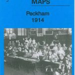 Peckham 1914 – 103.3
 Chesterfield 1914 – 25.06b
 Bethnal Green & Bow 1914 – 52.3
 Canning Town & Custom House 1914 – 66.3
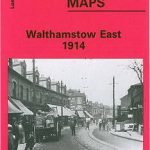 Walthamstow (East) 1914 – 15.3
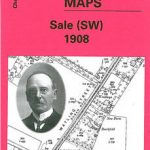 Sale South-West 1908
 Bermondsey & Wapping 1914 – 77.3
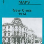 New Cross 1914 – 104.3
Farington South and Leyland North 1909
New Cross 1914 – 104.3
Farington South and Leyland North 1909
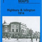 Highbury & Islington 1914 – 39.3
 West Drayton South 1935
Tannochside & North Uddingston 1935 – 11.03
Crook West 1895
West Drayton South 1935
Tannochside & North Uddingston 1935 – 11.03
Crook West 1895
 Brockley & Honor Oak 1914 – 118.3
Shefford 1900 – 22.12
Brockley & Honor Oak 1914 – 118.3
Shefford 1900 – 22.12
 Warwick North 1923
 East Dulwich & Peckham Rye 1914 – 117.3
Lenzie 1897
East Dulwich & Peckham Rye 1914 – 117.3
Lenzie 1897