Disclosure : This site contains affiliate links to products. We may receive a commission for purchases made through these links.
Chicago & Lake Michigan ITMB
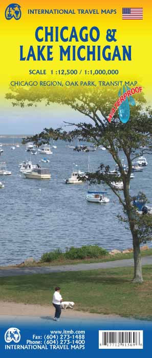
Chicago street plan and a road map of the region around Lake Michigan on a double-sided map from ITMB printed on light, waterproof and tear-resistant synthetic paper. On one side is a very clear, indexed street plan at 1:12,500 of Chicago’s central districts, providing coverage from Wrigley Field in the north to beyond the McCormick Place Convention Center, and inland to the Western Avenue. A separate inset covers the Oak Park area. Subway and Elevated Transit Line routes, including The Loop, and stops are clearly marked, and the transit system is also shown on a separate diagram. For drivers the plan highlights main traffic arteries and indicates one way streets. Symbols mark numerous places of interest, including locations of several hotels. Also provided is a map with main roads across the city, including access to the O’Hare International Airport.On the reverse is an indexed road map at 1:1,000,000 of the region around Lake Michigan, extending west to include Peoria and Springfield in Illinois, south beyond Indianapolis and Cincinnati, and east to include Detroit and Columbus, OH.To see other regional titles from ITMB covering USA please click on the series link.

Related Products:
 NOAA Chart 14926 – SMALL-CRAFT BOOK CHART – Chicago and South Shore of Lake Michigan (book of 30 charts)
 US/Canada Border ITMB
 Seattle & Northwest USA ITMB
 Montreal & Southern Quebec ITMB
 San Diego & USA South West Border ITMB
 Iran & Tehran ITMB
 Southern Ontario ITMB
 Chicago Borch
 Santiago & Chile North ITMB
 Rome & Southern Italy ITMB
 Czech Republic ITMB
 Toronto & Southern Ontario ITMB
 Chicago Regional Rand McNally
 Los Angeles & Southern California ITMB
 Geneva & Switzerland ITMB
 Philadelphia & Mid-Atlantic States ITMB
 Kyoto & Japan West ITMB
 Osaka & Western Japan ITMB
 Paris & France North ITMB
 Orlando & Central Florida ITMB
 Munich & Bavaria ITMB
 San Francisco & Northern California ITMB
 Lebanon & Beirut ITMB
Sweden ITMB Railway & Road Map
Lebanon & Beirut ITMB
Sweden ITMB Railway & Road Map
 Kuwait & Kuwait City ITMB
 Chad ITMB
 Southern Quebec ITMB
 Quito & Central Ecuador ITMB
 Finland & Sweden ITMB
 Hungary & Budapest ITMB
 Jakarta ITMB
 Zurich & Switzerland NW ITMB
 Singapore & Malay Peninsula ITMB
 Chicago IL Rand McNally
 Lima & Central Peru ITMB
 Chile ITMB
 Hanoi – Vietnam North ITMB
 Bangkok & Thailand South ITMB
 Chicago NGS City Destination Map
 England & Wales ITMB