Disclosure : This site contains affiliate links to products. We may receive a commission for purchases made through these links.
Cheadle and Cheadle Heath 1897
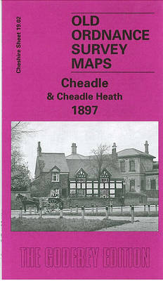
Cheadle and Cheadlle Heath in 1897 in a fascinating series of reproductions of old Ordnance Survey plans in the Alan Godfrey Editions, ideal for anyone interested in the history of their neighbourhood or family. The map covers the eastern part of Cheadle, extending from St Mary`s church and Cheadle station (both on margin of map) eastward to Cheadle Heath. Features include Adswood Hall, Bird Hall, Cheadleheath House, St Augustine`s church, The Grange, Congregational Chapel, Cheadle Hall, Abney Hall, etc. On the reverse are directories of Cheadle and Cheadle Heath, together with a railway timetable for the Manchester-Cheadle line in 1897. About the Alan Godfrey Editions of the 25″ OS Series:Selected towns in Great Britain and Ireland are covered by maps showing the extent of urban development in the last decades of the 19th and early 20th century. The plans have been taken from the Ordnance Survey mapping and reprinted at about 15 inches to one mile (1:4,340). On the reverse most maps have historical notes and many also include extracts from contemporary directories. Most maps cover about one mile (1.6kms) north/south, one and a half miles (2.4kms) across; adjoining sheets can be combined to provide wider coverage.FOR MORE INFORMATION AND A COMPLETE LIST OF ALL AVAILABLE TITLES PLEASE CLICK ON THE SERIES LINK.

Related Products:
 Buxton 1897 – 15.13
 Stockport East 1897
 Sacriston 1897
Bothwell & Blantyre 1897 – 11.11
Sacriston 1897
Bothwell & Blantyre 1897 – 11.11
 Romiley 1897
 Timperley 1897
Barnard Castle 1897 – 52.04a
Timperley 1897
Barnard Castle 1897 – 52.04a
 Bexley Heath 1862
 Hazel Grove 1897
Port Sunlight and Bebington 1897
Hamilton Low Parks 1897
Hazel Grove 1897
Port Sunlight and Bebington 1897
Hamilton Low Parks 1897
 St Albans South-West 1897
Tow Law 1897
Craigendoran and Helensburgh East 1897
Newton Heath 1915
Lenzie 1897
Uddingston 1897 – 11.07
Whetstone 1897
East Barnet & Southgate 1897 – 7.09
St Albans South-West 1897
Tow Law 1897
Craigendoran and Helensburgh East 1897
Newton Heath 1915
Lenzie 1897
Uddingston 1897 – 11.07
Whetstone 1897
East Barnet & Southgate 1897 – 7.09
 Stockton on Tees & Thornaby 1897 – 50.16a
Dumbarton 1897
Stonefield, Auchinraith & Burnbank 1897 – 11.15
Meadowfield 1897
Langley Moor and Brandon Colliery 1897
Motherwell (East) 1897 – 12.14
Durham City South 1897
Stockton on Tees & Thornaby 1897 – 50.16a
Dumbarton 1897
Stonefield, Auchinraith & Burnbank 1897 – 11.15
Meadowfield 1897
Langley Moor and Brandon Colliery 1897
Motherwell (East) 1897 – 12.14
Durham City South 1897
 Cradley Heath and Old Hill 1901
Coatdyke 1897 – 8.09
Cradley Heath and Old Hill 1901
Coatdyke 1897 – 8.09
 Swansea 1897 – 24.05
Hopwood Hall and Thornham 1907
Swansea 1897 – 24.05
Hopwood Hall and Thornham 1907
 Tong 1905
Thornton Heath and Norbury 1894
Pedmore 1921
Tong 1905
Thornton Heath and Norbury 1894
Pedmore 1921
 Swansea (North) 1897 – 24.01
Ashbourne, Cheadle and District 1895
Parkhead 1897 – 6.16
Bishop Middleham & Mainsforth Hall 1896 – 35.15
King`s Norton 1903
Swansea (North) 1897 – 24.01
Ashbourne, Cheadle and District 1895
Parkhead 1897 – 6.16
Bishop Middleham & Mainsforth Hall 1896 – 35.15
King`s Norton 1903
 New Hartley and Delaval Hall 1896
Coatbridge 1897
New Hartley and Delaval Hall 1896
Coatbridge 1897