Disclosure : This site contains affiliate links to products. We may receive a commission for purchases made through these links.
Chattanooga – Knoxville – Sevier County TN Rand McNally
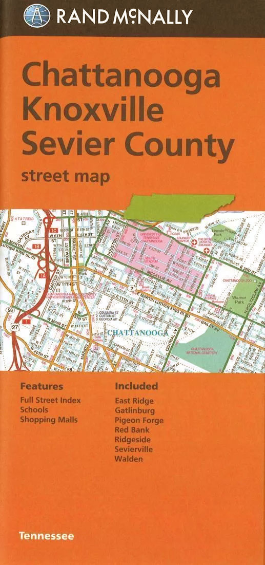
Towns of Eastern Tennessee: Chattanooga, Knoxville and the Sevier County on an indexed street plan from Rand McNally in their extensive range of maps covering cities in the United States. Communities covered by this map include East Ridge, Gatlinburg, Pigeon Forge, Red Bank, Ridgeside, Sevierville and WaldenRand McNally street plans provide coverage of cities with their outer suburbs, clearly indicating main traffic arteries: highways (distinguishing between free and toll access), plus primary and secondary routes. Road numbers and/or names are clearly displayed and exit numbers are indicated. Locations of service and rest areas are marked and one way streets are shown. Longer streets are annotated with block numbers for easier identification of addresses. The maps show railway, bus and, where appropriate, metro stations. A range of symbols indicate various places of interest including cultural and academic institutions, various municipal facilities, golf courses, etc. The plans have extensive street indexes, supplemented by lists of points of interest, parks and recreational areas, shopping malls, stations, schools, etc.

Related Products:
 Jacksonville FL Rand McNally
 Baton Rouge LA Rand McNally
 Syracuse NY Rand McNally
 Fort Worth TX Rand McNally
 Louisville KY Rand McNally
 Colorado Springs CO Rand McNally
 Washington D.C. Rand McNally
 Greensboro – Winston – Salem NC Rand McNally
 Boise – Nampa – Caldwell ID Rand McNally
 Northern Virginia Rand McNally
 Birmingham AL Rand McNally
 Fort Myers – Cape Coral FL Rand McNally
 Kansas City MO/KS Rand McNally
 Des Moines – Ames IA Rand McNally
 Cleveland – Cuyahoga County OH Rand McNally
 Anchorage – Fairbanks – Juneau – Ketchikan AK Rand McNally
 New York City 5-Borough Rand McNally
 Albuquerque NM Rand McNally
 Phoenix AZ Rand McNally
 Memphis TN Rand McNally
 New Orleans LA Rand McNally
 Philadelphia PA Rand McNally
 San Antonio TX Rand McNally
 Charleston SC Rand McNally
 Chicago IL Rand McNally
Pittsburgh PA Rand McNally
Chicago IL Rand McNally
Pittsburgh PA Rand McNally
 Boston MA Rand McNally
 San Francisco – Northern Peninsula Cities CA Rand McNally
 Rochester NY Rand McNally
 Indianapolis IN Rand McNally
 Portland OR Rand McNally
 St Louis MO Rand McNally
 Atlanta GA Rand McNally
 Raleigh – Durham NC Rand McNally
 San Diego CA Rand McNally
 Cincinnati OH Rand McNally
Nashville TN Rand McNally
Cincinnati OH Rand McNally
Nashville TN Rand McNally
 Dallas TX Rand McNally
 Seattle WA Rand McNally
 Sacramento CA Rand McNally