Disclosure : This site contains affiliate links to products. We may receive a commission for purchases made through these links.
Disclosure : This site contains affiliate links to products. We may receive a commission for purchases made through these links.
Categories
-
Best Sellers
-

Hardangerjรธkulen Nordeca 10039
Map No. 10039, Hardangerjรธkulen, in the new topographic survey of Norway at 1:50,000 covering the country on 195 double-sided sheets and first published by Nordeca in Read More » -
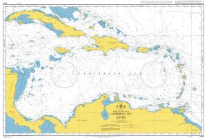
Admiralty Chart 4402 – Caribbean Sea
NEW EDITION OUT ON 24/09/2020Admiralty standard nautical charts comply with Safety of Life at Sea (SOLAS) regulations and are ideal for professional, commercial and recreational use. Read More » -

Ruth the Red Riding Hood Fairy
The Wetherbury Storytelling Festival is almost over, but first Rachel and Kirsty must get one more magical object back from Jack Frost. Can they find Ruth`s Read More » -

Petershausen M11
Petershausen in a series of GPS compatible recreational editions of the Bavarian topographic survey at 1:25,000, with waymarked hiking trails and cycling routes, campsites and youth Read More » -

Fire and Blood: 300 Years Before A Game of Thrones (A Targaryen History) (A Song of Ice and Fire)
Set 300 years before the events in A Song of Ice and Fire, FIRE AND BLOOD is the definitive history of the Targaryens in Westeros as Read More » -

Harz West Kompass 451
Western Harz Mountains around Goslar, Osterode and Bad Sachsa on a detailed, GPS compatible map at 1:50,000 from Kompass with local and long-distance footpaths, cycling routes, Read More » -

Footprint – Our Landscape in Flux
These captivating landscapes by the Magnum photographer Stuart Franklin provide a visual document of Europe in the midst of a growing environmental crisis. Technically flawless, cool, Read More » -

Ellen Giggenbach Origami: Animals
The magnificent art of origami is brought to life in this beautiful book, adorned with Ellen Giggenbach`s very own animal designs. With the spiral-bound instructions and Read More » -

The Sky Over Lima
Peru, 1904. Jose Galvez and Carlos Rodriguez are poets. Or, at least, they`d like to be.Sons of Lima`s elite in the early twentieth century, they scribble Read More » -

Gravelly Hill 1886: Warwickshire Sheet 8.14A
-


