Disclosure : This site contains affiliate links to products. We may receive a commission for purchases made through these links.
Cerdagne-Capcir Rando Editions 8
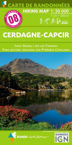
The Cerdagne-Capcir region of the French Pyrenees, from Ax-les Thermes to Font Romeu and Bourg-Madame, on a contoured and GPS compatible map at 1:50,000 from Rando Editions with topographic base provided by the IGN, highlighting local and long-distance hiking trails, etc. Topography is vividly presented by contours at 20m intervals enhanced by shading and graphic relief, plus colouring for woodlands and brushwood. An overprint highlights waymarked local and long-distance trails, including the course of the GR10, as well as other hiking paths, indicating difficult sections and traverses across ice. A wide range of symbols presents different accommodation options (campsites, mountain refuges or lodges, gรฎtes d’etape), locations for various recreational pursuits (mountain biking, climbing, hand gliding, canoeing and rafting, etc), historical and cultural sites, tourist information offices, etc. On the Spanish side of the border, main hiking trails are highlighted but other recreational and tourist information is limited. The map has a 2km UTM grid and its map legend includes English. Current 6th edition of this title was published in 2010.To see the list of titles in this series please click on the series link.

Related Products:
 Haute-Ariรฉge Rando Editions 7
 Luchon Rando Editions 5
 Le Sentier Cathare – Queribus – Peyrepertuse Rando Editions 9
 Pays Basque East Rando Editions 2
 Bรฉarn – Aspe – Ossau – Pyrenees National Park Rando Editions 3
 Collioure-Cadaquรฉs Rando Editions 11
 Bigorre – Cauterets – Gavarnie – Saint-Lary-Soulan – Pyrenees NP Rando Editions 4
 Pyrenees Rando Editions
 Cariboo Chilcotin ITMB
 Bled Pocket Map
 Okanagan & Shuswap ITMB
 Mercantour & Alpi-Marittime Didier Richard 07
 Triglav Pocket Map
 Karavanke Mountains – Kep to Kosuta Kartografija WATERPROOF Hiking Map
 Kamnik and Savinja Alps Kartografija WATERPROOF Hiking Map
 Besseggen Nordeca 2649
 Gullfjellet Nordeca 2713
 Glittertinden Nordeca 2757
 Galdhopiggen Nordeca 2655
 Gaustatoppen Nordeca 2657
 Hurrungane Nordeca 2758
 Geirangerfjorden Nordeca 2760
 Snรธheim Nordeca 2784
 Kootenay National Park Gem Trek Map
 Romsdalseggen og Trolltindene Nordeca 2756
 Oslo Vestmark Nordeca 2795
 Oslo รstmark Nordeca 2794
 Oslo Nordmark South Nordeca 2826
 Bergen – 7-Mountains Hike Nordeca 2429
 Dovrefjell – Snรธhetta Nordeca 2829
 Stavanger and North Jaeren Nordeca 2762
 Canadian Rockies – Banff – Kootenay – Yoho Parks ITMB
 Ljubljana and Environs Kartografija Tourist Map
 Coast to Coast West Mountain Bikers & Cyclists: St Bees to Kirkby Stephen
 Primorska Kartografija Tourist Map
 Triglav Slovenian Alpine Club 25K Map
 Posavsko Hribovje Kartografija Tourist Map
 Louisiana Recreational Atlas & Gazetteer
 Adirondacks NY