Disclosure : This site contains affiliate links to products. We may receive a commission for purchases made through these links.
Central Middlesbrough 1913 – 6.14b
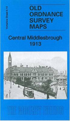
Central Middlesbrough in 1913 in a fascinating series of reproductions of old Ordnance Survey plans in the Alan Godfrey Editions, ideal for anyone interested in the history of their neighbourhood or family. Two versions have been published for this area. The map extends from Wilson Street southward to Albert Park, and from Newport Iron Works eastward to North Ormesby Street. Features on the 1892 version include the Town Hall and Municipal Buildings, tramways, Infirmary, Post Office, Newport Rolling Mills, Newport Iron Works, Ayresome Ward, part of Albert Park, engine sheds, Middlesbrough Football Ground, Nazareth House orphanage, etc. On the reverse is a selection of street entries from a 1905 directory, including Corporation Road, Grange Road West and Linthorpe Road. The 1892 version is in colour, taken from the beautiful hand-coloured 1st Edition.About the Alan Godfrey Editions of the 25″ OS Series:Selected towns in Great Britain and Ireland are covered by maps showing the extent of urban development in the last decades of the 19th and early 20th century. The plans have been taken from the Ordnance Survey mapping and reprinted at about 15 inches to one mile (1:4,340). On the reverse most maps have historical notes and many also include extracts from contemporary directories. Most maps cover about one mile (1.6kms) north/south, one and a half miles (2.4kms) across; adjoining sheets can be combined to provide wider coverage.FOR MORE INFORMATION AND A COMPLETE LIST OF ALL AVAILABLE TITLES PLEASE CLICK ON THE SERIES LINK.

Related Products:
 Middlesbrough North 1913
Middlesbrough North 1893 (Colour Edition)
Manchester North West and Central Salford 1915
Sheffield (North) 1903 – 294.04b
Sheffield Central 1903
Middlesbrough North 1913
Middlesbrough North 1893 (Colour Edition)
Manchester North West and Central Salford 1915
Sheffield (North) 1903 – 294.04b
Sheffield Central 1903
 Brixton & Herne Hill 1913 – 116.3
Birmingham North 1913
Brixton & Herne Hill 1913 – 116.3
Birmingham North 1913
 Birmingham Central 1913
Nottingham NW (New Basford & Hyson Green) 1913 – 38.13
Nottingham North 1913
Byker and Heaton 1913
Camberwell & Stockwell 1913 – 102.3
Tynemouth 1913
Birmingham Central 1913
Nottingham NW (New Basford & Hyson Green) 1913 – 38.13
Nottingham North 1913
Byker and Heaton 1913
Camberwell & Stockwell 1913 – 102.3
Tynemouth 1913
 Battersea & Clapham 1913 – 101.3
Elswick 1913
Leeds Central and North East 1890
Springburn and Possilpark 1893
Central Sunderland 1895 – 8.14
The Hawthorns 1913
Battersea & Clapham 1913 – 101.3
Elswick 1913
Leeds Central and North East 1890
Springburn and Possilpark 1893
Central Sunderland 1895 – 8.14
The Hawthorns 1913
 Central Leeds 1906 – 218.02b
Stockton (North) 1899 – 50.12a
Wishaw 1896
Walthamstow Marshes 1913 – 22.3
Belfast (East) 1902 – 4.11
Central Newcastle 1894 – 11a
Bulwell 1913 – 38.05
Central Croydon 1895 – 14.10
Trafford Park South 1937
Glasgow Green 1892
Kentish Town & Camden 1913 – 38.3
Birmingham South 1913
Central Leeds 1906 – 218.02b
Stockton (North) 1899 – 50.12a
Wishaw 1896
Walthamstow Marshes 1913 – 22.3
Belfast (East) 1902 – 4.11
Central Newcastle 1894 – 11a
Bulwell 1913 – 38.05
Central Croydon 1895 – 14.10
Trafford Park South 1937
Glasgow Green 1892
Kentish Town & Camden 1913 – 38.3
Birmingham South 1913
 Keighley North 1913
East Jarrow 1913
Putney 1913 – 113.3
Chelsea 1913 – 87.3
Euston & Regent`s Park 1913 – 49.3
Coatbridge 1910 – 7.12b
Coatbridge 1897
Keighley North 1913
East Jarrow 1913
Putney 1913 – 113.3
Chelsea 1913 – 87.3
Euston & Regent`s Park 1913 – 49.3
Coatbridge 1910 – 7.12b
Coatbridge 1897
 Clapham Park & Balham 1913 – 125.3
 Highgate 1913 – 19.3