Disclosure : This site contains affiliate links to products. We may receive a commission for purchases made through these links.
Central Macedonia Terrain Editions Regional Map 2
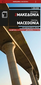
Central Macedonia at 1:200,000 in a series of regional road maps of Greece from Terrain Editions, printed on light, waterproof and tear-resistant synthetic paper. The map is double-sided, with Thessaloniki on both sides, and includes coverage of the Khalkidhiki Peninsula. Topography is shown by relief shading with light altitude colouring and plenty of names of mountain ranges. All place names are in both Greek and Latin alphabets. Presentation of the road network differentiates between smooth and rough dirt roads, and shows driving distances on many local roads plus locations of petrol stations. Scenic routes are highlighted. Railway lines and ferry routes are included. A range of symbols indicate various places of interest including campsites and mountain refuges, archaeological sites, churches and monasteries, skiing areas, etc. The map has a 10km UTM grid, with latitude and longitude shown by margin ticks and crosshairs at 10’. Map legend includes English. The index, separate for the Greek and Latin alphabet place names and with lists of monasteries and archaeological sites, is in a separate booklet; unlike in some titles in this series no street plans are included.

Related Products:
 Thrace and Eastern Macedonia Terrain Editions Regional Map 1
 Epirus and Western Macedonia Terrain Editions Regional Map 3
 Central Crete Terrain Editions 449
 Cyclades Terrain Editions Regional Map 8
 Crete Terrain Editions Regional Map 7
 Chalkidiki / Halkidiki – Thessaloniki Street Plan Terrain Editions 412
 Eastern Crete Terrain Editions 450
 Western Crete Terrain Editions 448
 Greece Terrain Editions
 Crere: Heraklion Prefecture 150K Terrain Editions Map
 Crete: Lasithi Prefecture 150K Terrain Editions Map
 Crete: Chania Prefecture 150K Terrain Editions Map
 Crete: Rethymno Prefecture 150K Terrain Editions Map
 Greece: Terrain Editions 100K Touring Maps of Crete
 Greece: Terrain Editions 150K Road Maps of Crete
 Evia / Euboea Terrain Editions
 Macedonia Anavasi Regional Map R4
 Greece: Attika and Central Greece Road Atlas
 Mt Athos Terrain Editions 209
 Greece: Terrain Editions Maps for Hiking and Recreational Pursuits
 Central Greece – Thessaly – Epirus Anavasi Regional Map R3
 Zakynthos Terrain Editions 355
 Spetses Terrain Editions 360
 Attica – Boeotia Anavasi 10
 Iraklion – Rethymnon – Central Crete Anavasi 93
Pelion Central Terrain Editions 218
Iraklion – Rethymnon – Central Crete Anavasi 93
Pelion Central Terrain Editions 218
 Peloponnese Anavasi Road Atlas
 Greece F&B
 Kalymnos Terrain Editions 337
 Kythira Terrain Editions 346
 Kea / Tzia Terrain Editions 301
 Anafi Terrain Editions 318
 Peloponnese Anavasi Regional Map R2
 Kos Terrain Editions Map 338
 Mt Hymettus Terrain Editions 241
 Ios Terrain Editions 315
 Fourni Terrain Editions 333
 Karpathos – Kasos Terrain Editions 345
 Kythnos Terrain Editions 302