Disclosure : This site contains affiliate links to products. We may receive a commission for purchases made through these links.
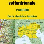
Central Italy TCI 400K Road and Tourist Map

Central Italy at 1:400,000 from the Touring Club Italiano, printed on light, waterproof and tear-resistant plastic paper; one of the titles in a series of three touring maps conveniently grouping together several popular holiday areas. The maps very effectively present the country’s topography with attractive altitude colouring, supplemented by names of numerous hill and mountain ranges, valleys, etc, plus spot heights for selected peaks. National parks and scenic routes are highlighted. National parks and scenic routes are highlighted. Grading according to the degree of importance and interest is given not only to towns, villages and historical or architectural sites, but also to holiday resorts and natural curiosities. Symbols highlight churches, monasteries, castles, palaces, ruins and archaeological sites, caves and waterfalls, etc. The maps also provide some information on accommodation, indicating selected isolated hotels, refuges, tourist villages and campsites, Road network stands out clearly against the background information. Railways, ferry routes and the country’s regional and provincial boundaries are also marked. The maps have no geographical coordinates or an index. Map legend includes English.

Related Products:
 Northern Italy TCI 400K Road and Tourist Map
 Southern Italy – Sardinia – Sicily TCI 400K Road and Tourist Map
 Italy: Touring Club Italiano 400K Road Maps
 Italy North – Central TCI 500K Road Map
 Italy: Touring Club Italiano 200K Regional Road Maps
 Italy South TCI 500K Road Map
 Italy: Michelin 400K Touring Maps
 Italy Philip`s Road Map
 Italy: Freytag & Berndt “Top 10 Tips” Road Maps
 Italy Marco Polo Road Atlas
 Italy Central Michelin Regional 563
 Great Britain: Michelin 400K Road Maps
 Greece: Attika and Central Greece Road Atlas
 Italy AA Road Map
Italy TCI Road Atlas
Italy AA Road Map
Italy TCI Road Atlas
 Central Latvia Jana Seta Tourist Map
 Finland: Karttakeskus 250/400K GT Road Maps
 Finland: Karttakeskus 250K/400K Outdoor Maps
 Albania Central
Roztocze Central ExpressMap Tourist Map
Albania Central
Roztocze Central ExpressMap Tourist Map
 Central Europe F&B Compact Road Atlas
 China Central Gizi Map
 Central America NGS Classic Wall Map PAPER
Italy F&B Great Road Atlas SPIRAL-BOUND
Central America NGS Classic Wall Map PAPER
Italy F&B Great Road Atlas SPIRAL-BOUND
 Alps – Northern Italy MairDumont Road Atlas SPIRAL-BOUND
 Italy: IGA 25K Hiking Maps of Central Italy
 Italy: IGA 50K Hiking Maps of Central Italy
 Central Southern England AA Road Map 2
 Midlands & Central England AA Road Map 5
 Central Crete Terrain Editions 449
 Mexico: ITMB Regional Road Maps
 Sweden Central – Sundsvall ‘“ Falun – Gavle F&B
 Lombardy – Milan – Lakes in Northern Italy F&B Top 10 Tips
 Central America NGS Classic Wall Map ENCAPSULATED
 Iraklion – Rethymnon – Central Crete Anavasi 93
 Central America ITMB
 Italy: MairDumont Marco Polo 200K Regional Road Maps
 Castilla-la-Mancha Autonomous Region 400K CNIG Physical Road Map
Croatian Coast K+F Road Map
Castilla-la-Mancha Autonomous Region 400K CNIG Physical Road Map
Croatian Coast K+F Road Map
 Greece: Terrain Editions 150K Road Maps of Crete