Disclosure : This site contains affiliate links to products. We may receive a commission for purchases made through these links.
Cayman Islands & Jamaica ITMB

Cayman Islands and Jamaica on an indexed map from ITMB, presenting the individual Cayman islands at 1:37,500 with a street plan George Town, plus on the reverse Jamaica at 1:250,000 with plans of Kingston and five other locations.On one side Cayman Islands are shown on two separate panels: Grand Cayman Island, plus Little Cayman with Cayman Brac. A separate small inset shows all three in their proper geographical location. Graphic indicate mangrove or marshes, and along the coast coral reefs are marked. Protected Marine Parks are highlighted. Symbols indicate numerous diving sites, beaches, caves, selected tourist accommodation, petrol stations, etc. The panels have latitude and longitude lines at intervals of 5’ or 10’. The index lists both locations and street names. A street plan of George Town is also annotated with places of interest. On the reverse is a map of Jamaica at 1:250,000. Altitude colouring (in feet) indicates the topography, with spot heights (in both metres and feet), plus graphic for swamps and coral reefs. Road network includes selected local tracks, shows distances on main routes and indicates locations of petrol stations. Symbols highlight numerous beaches and other places of interest. The map is indexed and has latitude and longitude lines at 15’ intervals. Street plans, annotated with places of interest and selected accommodation show Kingston, Montego Bay, Mandeville, Spanish Town and Ocho Rios. Also provided is a distance table.

Related Products:
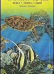
 Cayman Islands Guide & Dive Map
 Caribbean Islands Western Half ITMB Travel Atlas
 Fodor`s In Focus Cayman Islands
 Virgin Islands (US and British) ITMB
 Tahiti & Cook Islands ITMB
 Caribbean Islands East & South ITMB Travel Atlas
 Cayman Islands Official Log Book
 Canary Islands ITMB
 Galapagos Islands – Quito & Guayaquil ITMB
 Polynesian Islands ITMB Travel Atlas
 Cayman Islands GMDSS Radio Log Book
 Hawaii & Honolulu ITMB
 Kilimanjaro & Tanzania North ITMB
 Antigua & Dominica ITMB
 Virgin Islands Borch
 Madagascar ITMB
 Sarawak – Sabah – Brunei ITMB
 Tanzania ITMB
 Cayman Islands Civil Ensign – 1yd – Printed
 Cayman Islands Civil Ensign – 2yd – Printed
 Cayman Islands Civil Ensign – 1yd – Sewn
 Cayman Islands Civil Ensign – 2yd – Sewn
 Cuba ITMB
 Australia ITMB
 Georgia & Armenia ITMB
 Cape Verde & West Africa ITMB
 Chile ITMB
 Cayman Islands Civil Ensign – 1/2 yard – Printed
 Dominica & Saint Lucia ITMB
 Patagonia & Tierra del Fuego ITMB
 Sri Lanka & India South ITMB
 Birdwatchers` Guide to Cuba, Jamaica, Hispaniola, Puerto Rico & the Caymans
Admiralty Chart Folio 86 – West Indies Islands from San Salvador and Jamaica to Antigua
Birdwatchers` Guide to Cuba, Jamaica, Hispaniola, Puerto Rico & the Caymans
Admiralty Chart Folio 86 – West Indies Islands from San Salvador and Jamaica to Antigua
 NGA Chart 27241 – Little Cayman and Cayman Brac
 Namibia ITMB
 Panama ITMB
 Hawaiian Islands
 Togo & Benin ITMB
 Bhutan & Northeast India ITMB