Disclosure : This site contains affiliate links to products. We may receive a commission for purchases made through these links.
Cavalls del Vent – Cadi-Moixero Natural Park Hiking Circuit Editorial Alpina
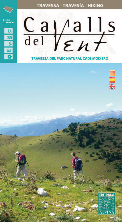
Cavalls del Vent, a 97km-long hiking circuit in the Cadรญ-Moixerรณ Natural Park with a cumulative altitude difference of 10,000 metres, presented by Editorial Alpina at 1:30,000 on a contoured and GPS compatible map with details of local mountain refuges plus a booklet with a 10-page English language descriptionThe map has contours at 20m intervals, enhanced by relief shading and numerous spot heights, plus colouring for different types of vegetation. The course of the Cavalls del Vent route is prominently highlighted. Other local walking paths are also marked, indicating where appropriate the GR and PR trails. A wide range of symbols shows various tourist facilities and places of interest, including different types of accommodation options (hotels, farms, refuges, campsites, youth hostels, etc), sport and recreational sites, etc. Road network indicates car parks and locations of petrol stations. The map has a 1km UTM grid plus latitude and longitude margin ticks at 1’ intervals. Map legend includes English.Next to the map is a route profile, plus full details of eight mountain refuges along the route. Accompanying booklet has a stage-by-stage English language description of the route.To see the list of all the maps from Editorial Alpina covering long-distance hiking routes please click on the series link.

Related Products:
 Menorca – Camรญ de Cavalls – GR223 Editorial Alpina CATALAN
 Menorca – Camรญ de Cavalls – GR223 Editorial Alpina ENGLISH
 Carros de Foc Hiking Circuit Editorial Alpina
 Posets-Maladeta Natural Park 2-Map Set Editorial Alpina
La Alta Ruta de los Perdidos – Monte Perdido – Vignemale Editorial Alpina Hiking Circuit Map
Posets-Maladeta Natural Park 2-Map Set Editorial Alpina
La Alta Ruta de los Perdidos – Monte Perdido – Vignemale Editorial Alpina Hiking Circuit Map
 Cabo de Gata-Nรญjar Natural Park Editorial Alpina
 Cap de Creus Park Natural Editorial Alpina
 Alt Pirineu Natural Park Editorial Alpina
 Aigรผestortes and Estany de Sant Maurici National Park 2-Map Set Editorial Alpina
 Ordesa and Monte Perdido National Park Editorial Alpina
Ordesa – Monte Perdido National Park Editorial Alpina 2-Map Set
Ordesa and Monte Perdido National Park Editorial Alpina
Ordesa – Monte Perdido National Park Editorial Alpina 2-Map Set
 La Senda de Camille Editorial Alpina
 Moixerรณ – La Tosa – Cadรญ-Moixerรณ Natural Park Editorial Alpina
 Ordesa and Monte Perdido National Park 2-Map Set Editorial Alpina
Spain: Editorial Alpina Maps of Long-distance Hiking Trails
Ordesa and Monte Perdido National Park 2-Map Set Editorial Alpina
Spain: Editorial Alpina Maps of Long-distance Hiking Trails
 Mallorca – Tramuntana Central Editorial Alpina
Collserola Parc Natural Editorial Alpina
Mallorca – Tramuntana Central Editorial Alpina
Collserola Parc Natural Editorial Alpina
 Montgrony – Fonts del Llogregat – Parc Natural del Cadรญ-Moixerรฒ Editorial Alpina
 Mallorca – Tramuntana South Editorial Alpina
 Mallorca – Tramuntana North Editorial Alpina
 Vall Fosca – Montsent de Pallars Editorial Alpina 2-Map Set
Montserrat Nature Park Editorial Alpina
Sierra Nevada – La Alpujarra Editorial Alpina
Vall Fosca – Montsent de Pallars Editorial Alpina 2-Map Set
Montserrat Nature Park Editorial Alpina
Sierra Nevada – La Alpujarra Editorial Alpina
 Ibiza – Formentera Editorial Alpina
 Serra de Tramuntana Editorial Alpina 4-Map Set
 Muntanyes de Llibertat Hiking Circuit
 Travessa 3 Refugis – Caranรงร – Ulldeter – Coma de Vaca Editorial Alpina
Cotiella ‘“ Peรฑa Montaรฑesa Editorial Alpina
Travessa 3 Refugis – Caranรงร – Ulldeter – Coma de Vaca Editorial Alpina
Cotiella ‘“ Peรฑa Montaรฑesa Editorial Alpina
 Tour of the Canigรณ Hiking Circuit
 Garrotxa – Zona Volcanica Editorial Alpina
 Valles de Belagua y Roncal Editorial Alpina
Valles de Ansรณ & Echo Editorial Alpina
Montseny NP – Turo de l`Home – Les Agudas – Matagalls – la Calma Editorial Alpina 2-Map Set
Valles de Belagua y Roncal Editorial Alpina
Valles de Ansรณ & Echo Editorial Alpina
Montseny NP – Turo de l`Home – Les Agudas – Matagalls – la Calma Editorial Alpina 2-Map Set
 Macizo de Monte Perdido – Valle de Ordesa – Pineta Editorial Alpina
Sant Llorenc del Munt i l`Obac Editorial Alpina
Macizo de Monte Perdido – Valle de Ordesa – Pineta Editorial Alpina
Sant Llorenc del Munt i l`Obac Editorial Alpina
 Pica d`Estats – Mont-roig Editorial Alpina
 Serra del Cadรญ – Pedraforca Editorial Alpina
Bachimala – Valles de Chistau y Bielsa Editorial Alpina
Serra del Cadรญ – Pedraforca Editorial Alpina
Bachimala – Valles de Chistau y Bielsa Editorial Alpina
 Taga – Serra Cavallera Editorial Alpina
Vall de Boรญ – Aigรผestortes PN Editorial Alpina
Taga – Serra Cavallera Editorial Alpina
Vall de Boรญ – Aigรผestortes PN Editorial Alpina