Category Archives: Travel Guides
CHS Chart 4406 – Tryon Shoals to Cape Egmont

The official Canadian charts provide an excellent range of scales for the whole length of Canada`s coastline as well as the Grat Lakes and comply with Safety of Life at Sea (SOLAS) regulations.PLEASE NOTE: Canadian Hydrographic Service charts are ordered on demand, please allow 1-2 weeks for the order to arrive at Stanfords.
CHS Chart 4419 – Souris Harbour and Approaches
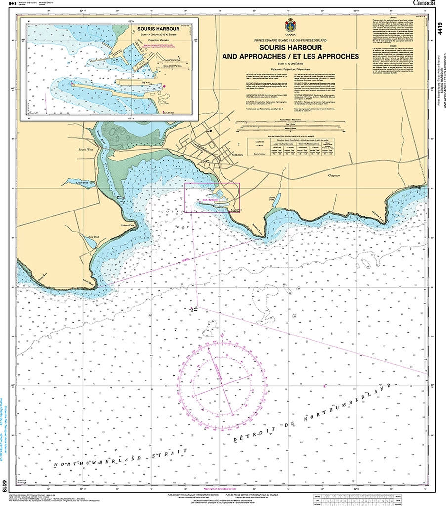
The official Canadian charts provide an excellent range of scales for the whole length of Canada`s coastline as well as the Grat Lakes and comply with Safety of Life at Sea (SOLAS) regulations.PLEASE NOTE: Canadian Hydrographic Service charts are ordered on demand, please allow 1-2 weeks for the order to arrive at Stanfords.
CHS Chart 4935 – Murray Harbour to Boughton Bay

The official Canadian charts provide an excellent range of scales for the whole length of Canada`s coastline as well as the Grat Lakes and comply with Safety of Life at Sea (SOLAS) regulations.PLEASE NOTE: Canadian Hydrographic Service charts are ordered on demand, please allow 1-2 weeks for the order to arrive at Stanfords.
CHS Chart 4925 – Harbours on the North Shore of Prince Edward Island
Savage Harbour 1:15,000Covehead Bay 1:15,000St. Peters Bay 1:25,000Tracadie Bay 1:25,000Entrance to St. Peters Bay 1:12,000The official Canadian charts provide an excellent range of scales for the whole length of Canada`s coastline as well as the Grat Lakes and comply with Safety of Life at Sea (SOLAS) regulations.PLEASE NOTE: Canadian Hydrographic Service charts are ordered on
CHS Chart 4938 – Pictou Harbour and East River of Pictou
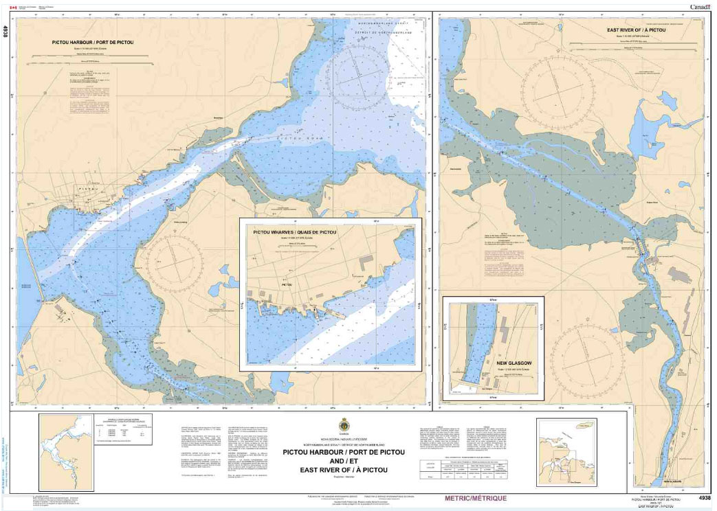
The official Canadian charts provide an excellent range of scales for the whole length of Canada`s coastline as well as the Grat Lakes and comply with Safety of Life at Sea (SOLAS) regulations.PLEASE NOTE: Canadian Hydrographic Service charts are ordered on demand, please allow 1-2 weeks for the order to arrive at Stanfords.
CHS Chart 4445 – Merigomish Harbour
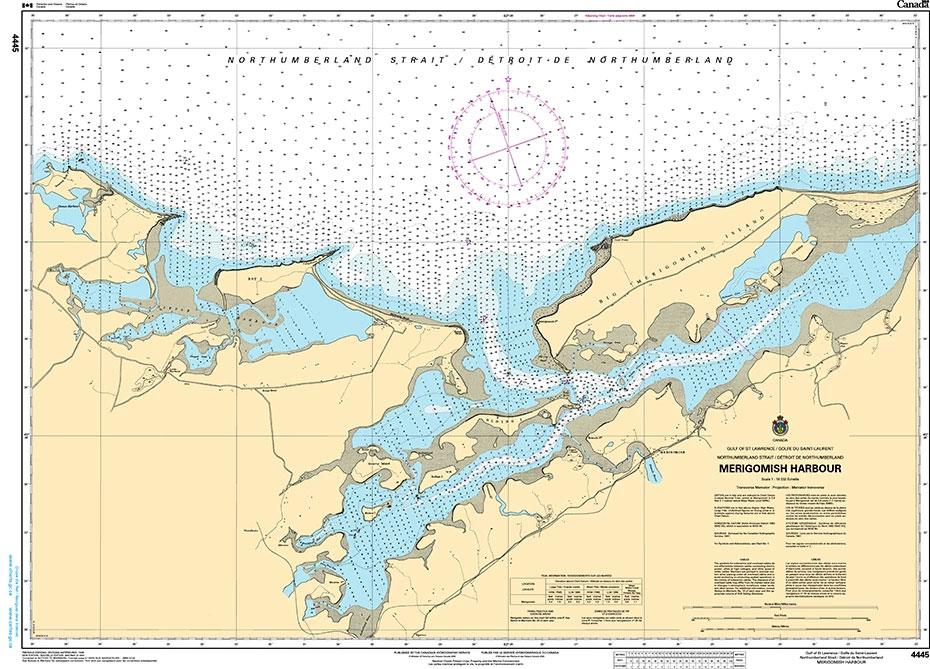
The official Canadian charts provide an excellent range of scales for the whole length of Canada`s coastline as well as the Grat Lakes and comply with Safety of Life at Sea (SOLAS) regulations.PLEASE NOTE: Canadian Hydrographic Service charts are ordered on demand, please allow 1-2 weeks for the order to arrive at Stanfords.
CHS Chart 4446 – Antigonish Harbour
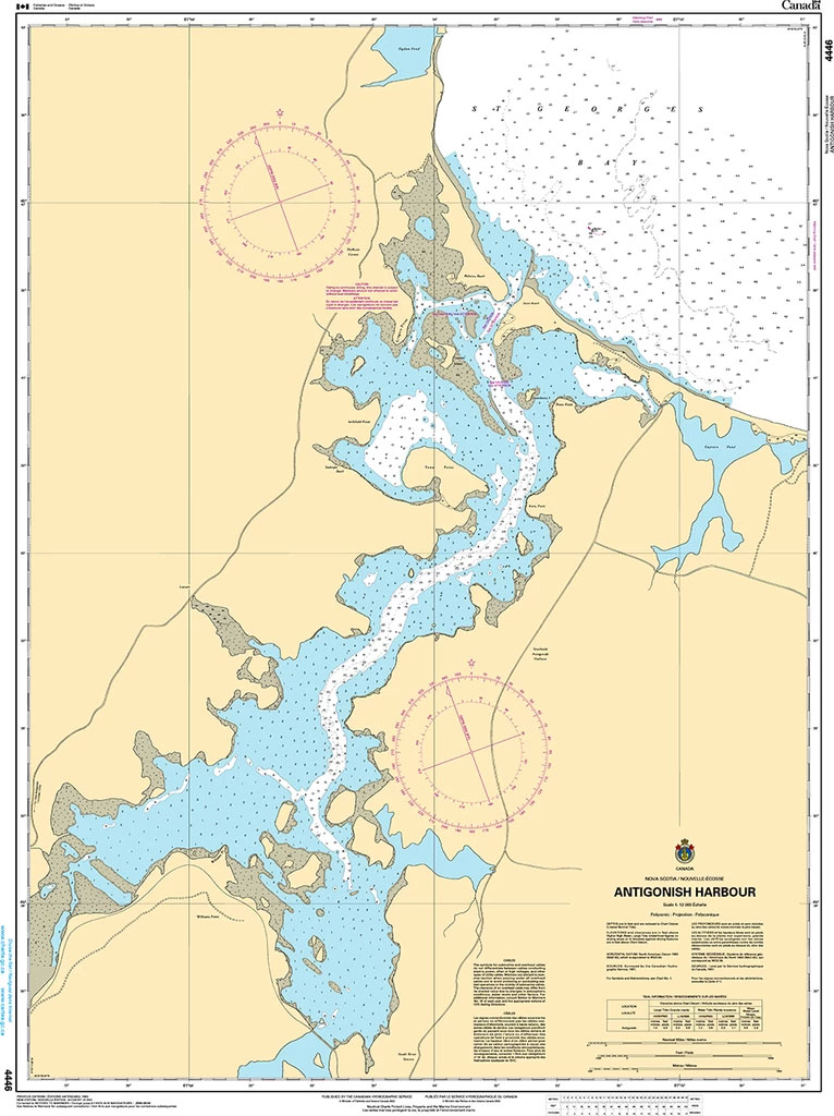
The official Canadian charts provide an excellent range of scales for the whole length of Canada`s coastline as well as the Grat Lakes and comply with Safety of Life at Sea (SOLAS) regulations.PLEASE NOTE: Canadian Hydrographic Service charts are ordered on demand, please allow 1-2 weeks for the order to arrive at Stanfords.
CHS Chart 4956 – Cap-aux-Meules

The official Canadian charts provide an excellent range of scales for the whole length of Canada`s coastline as well as the Grat Lakes and comply with Safety of Life at Sea (SOLAS) regulations.PLEASE NOTE: Canadian Hydrographic Service charts are ordered on demand, please allow 1-2 weeks for the order to arrive at Stanfords.
CHS Chart 4492 – Cascumpeque Bay
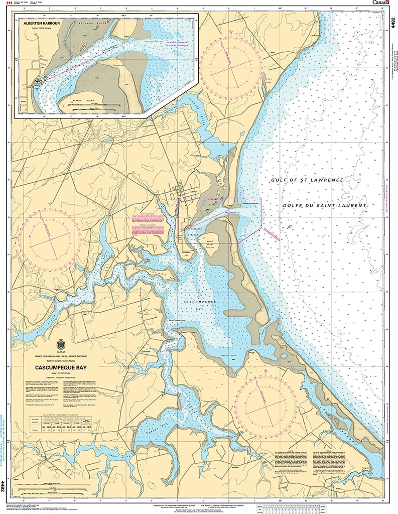
Plan included in this chart:Alberton Harbour 1:12,000The official Canadian charts provide an excellent range of scales for the whole length of Canada`s coastline as well as the Grat Lakes and comply with Safety of Life at Sea (SOLAS) regulations.PLEASE NOTE: Canadian Hydrographic Service charts are ordered on demand, please allow 1-2 weeks for the order
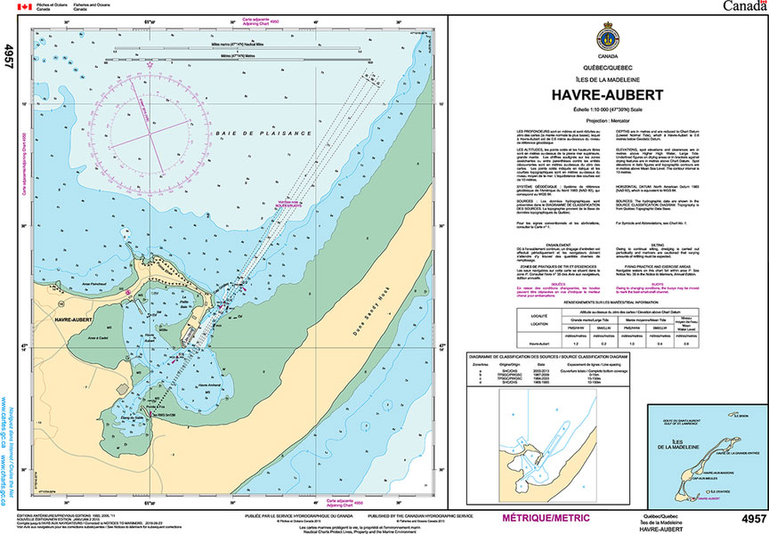
CHS Chart 4957 – Havre-Aubert

The official Canadian charts provide an excellent range of scales for the whole length of Canada`s coastline as well as the Grat Lakes and comply with Safety of Life at Sea (SOLAS) regulations.PLEASE NOTE: Canadian Hydrographic Service charts are ordered on demand, please allow 1-2 weeks for the order to arrive at Stanfords.
CHS Chart 4459 – Summerside Harbour and Approaches
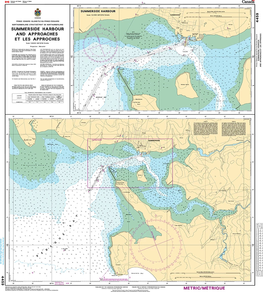
Plan included in this chart:Summerside Harbour 1:12,000The official Canadian charts provide an excellent range of scales for the whole length of Canada`s coastline as well as the Grat Lakes and comply with Safety of Life at Sea (SOLAS) regulations.PLEASE NOTE: Canadian Hydrographic Service charts are ordered on demand, please allow 1-2 weeks for the order
CHS Chart 4491 – Malpeque Bay
The official Canadian charts provide an excellent range of scales for the whole length of Canada`s coastline as well as the Grat Lakes and comply with Safety of Life at Sea (SOLAS) regulations.PLEASE NOTE: Canadian Hydrographic Service charts are ordered on demand, please allow 1-2 weeks for the order to arrive at Stanfords.
CHS Chart 4460 – Charlottetown Harbour
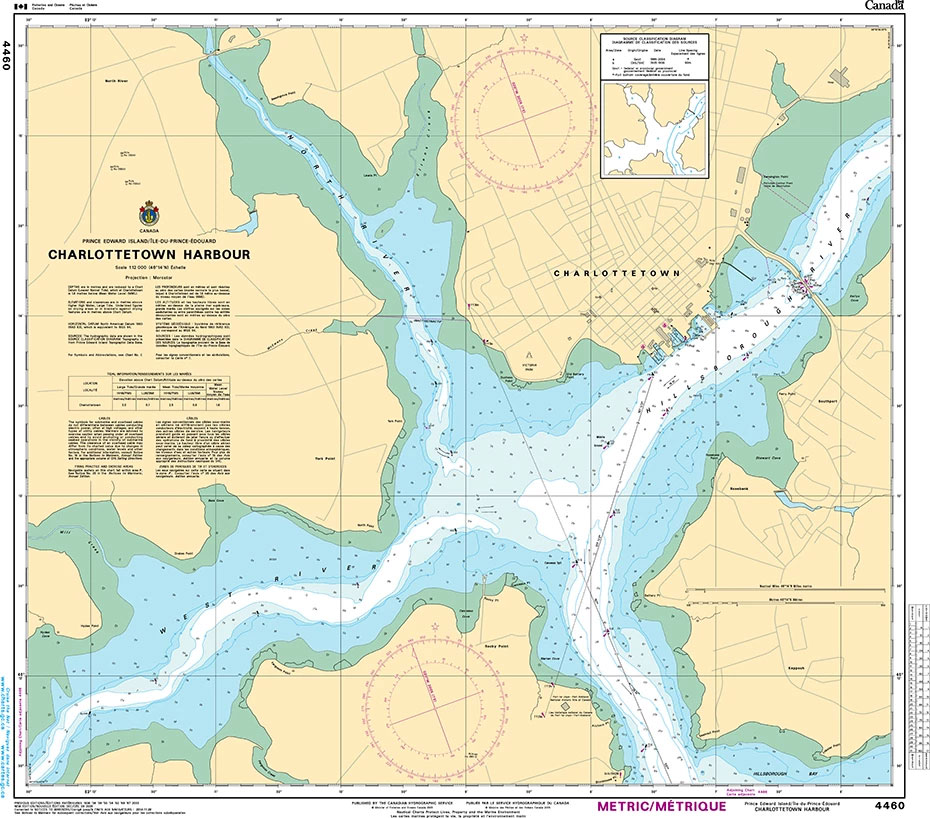
The official Canadian charts provide an excellent range of scales for the whole length of Canada`s coastline as well as the Grat Lakes and comply with Safety of Life at Sea (SOLAS) regulations.PLEASE NOTE: Canadian Hydrographic Service charts are ordered on demand, please allow 1-2 weeks for the order to arrive at Stanfords.
CHS Chart 4450 – Saint Paul Island
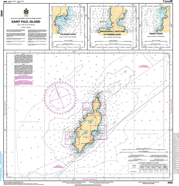
Plan included:Trinity Cove 1:12,164MacDougall and powers Coves 1:12,190Atlantic Cove 1:12,213The official Canadian charts provide an excellent range of scales for the whole length of Canada`s coastline as well as the Great Lakes and comply with Safety of Life at Sea (SOLAS) regulations.PLEASE NOTE: Canadian Hydrographic Service charts are ordered on demand, please allow 1-2 weeks
CHS Chart 4365 – Ingonish Harbour and Dingwall Harbour
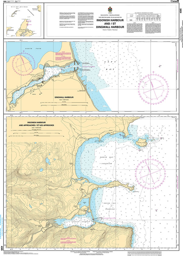
Plan includes:Dingwall Harbour 1:4,800Ingonish harbour and Approaches 1:18,000The official Canadian charts provide an excellent range of scales for the whole length of Canada`s coastline as well as the Grat Lakes and comply with Safety of Life at Sea (SOLAS) regulations.PLEASE NOTE: Canadian Hydrographic Service charts are ordered on demand, please allow 1-2 weeks for the
CHS Chart 4363 – Cape Smoky to St Paul Island
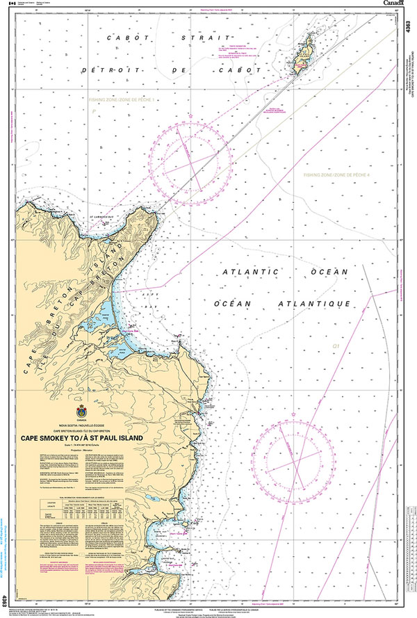
The official Canadian charts provide an excellent range of scales for the whole length of Canada`s coastline as well as the Grat Lakes and comply with Safety of Life at Sea (SOLAS) regulations.PLEASE NOTE: Canadian Hydrographic Service charts are ordered on demand, please allow 1-2 weeks for the order to arrive at Stanfords.
CHS Chart 4464 – Chรฉticamp to Cape St. Lawrence
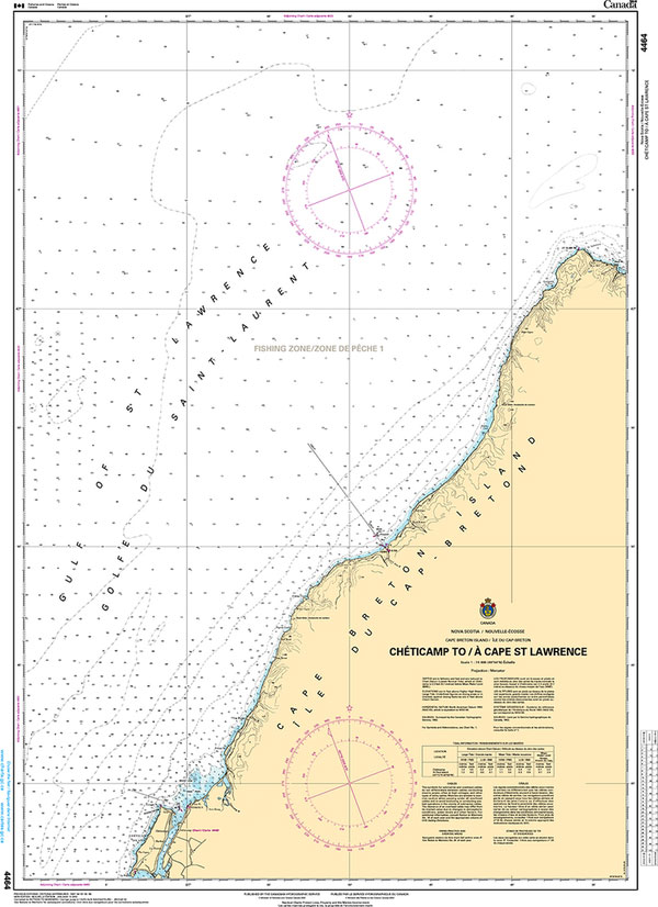
The official Canadian charts provide an excellent range of scales for the whole length of Canada`s coastline as well as the Grat Lakes and comply with Safety of Life at Sea (SOLAS) regulations.PLEASE NOTE: Canadian Hydrographic Service charts are ordered on demand, please allow 1-2 weeks for the order to arrive at Stanfords.
CHS Chart 4466 – Hillsborough Bay

The official Canadian charts provide an excellent range of scales for the whole length of Canada`s coastline as well as the Grat Lakes and comply with Safety of Life at Sea (SOLAS) regulations.PLEASE NOTE: Canadian Hydrographic Service charts are ordered on demand, please allow 1-2 weeks for the order to arrive at Stanfords.
CHS Chart 4463 – Chรฉticamp to Cape Mabou
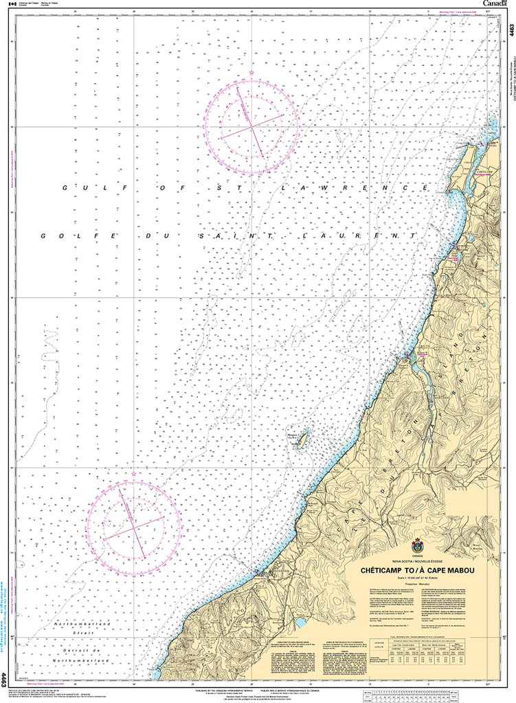
The official Canadian charts provide an excellent range of scales for the whole length of Canada`s coastline as well as the Grat Lakes and comply with Safety of Life at Sea (SOLAS) regulations.PLEASE NOTE: Canadian Hydrographic Service charts are ordered on demand, please allow 1-2 weeks for the order to arrive at Stanfords.
CHS Chart 4449 – Chรฉticamp Harbour / Grand รtang Harbour / Margaree Harbours
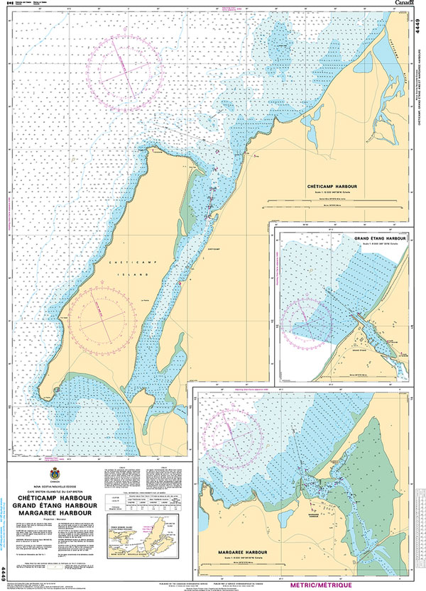
Plan includes:Grand Etang Harbour 1:6,000Margaree Habour 1:6,000Chรฉticamp Harbour 1:12,000The official Canadian charts provide an excellent range of scales for the whole length of Canada`s coastline as well as the Grat Lakes and comply with Safety of Life at Sea (SOLAS) regulations.PLEASE NOTE: Canadian Hydrographic Service charts are ordered on demand, please allow 1-2 weeks for