Category Archives: Travel Guides
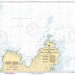
NZ531 Great Barrier Island (Aotea Island) to Mercury Bay
Nautical charts for New Zealand, created by Land Information New Zealand (LINZ), are printed on demand at Stanfords after your order is placed and processed. They provide a detailed coverage of the coastline with a varied range of scales – from overall route planning to detailed harbour charts.Notices to Mariners are available via this link.Source:
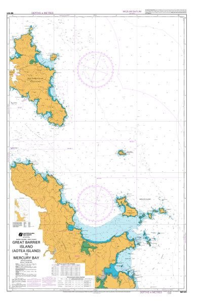
NZ532 Approaches to Auckland
Nautical charts for New Zealand, created by Land Information New Zealand (LINZ), are printed on demand at Stanfords after your order is placed and processed. They provide a detailed coverage of the coastline with a varied range of scales – from overall route planning to detailed harbour charts.Notices to Mariners are available via this link.Source:
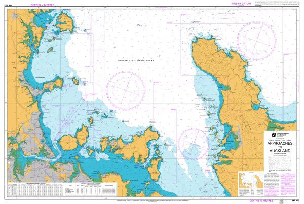
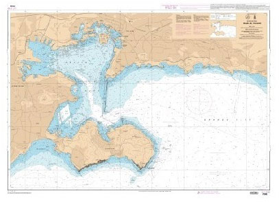
NZ533 Firth of Thames
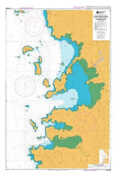
Nautical charts for New Zealand, created by Land Information New Zealand (LINZ), are printed on demand at Stanfords after your order is placed and processed. They provide a detailed coverage of the coastline with a varied range of scales – from overall route planning to detailed harbour charts.Notices to Mariners are available via this link.Source:
NZ534 Mercury Bay to Katikati Entrance
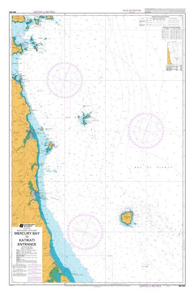
Nautical charts for New Zealand, created by Land Information New Zealand (LINZ), are printed on demand at Stanfords after your order is placed and processed. They provide a detailed coverage of the coastline with a varied range of scales – from overall route planning to detailed harbour charts.Notices to Mariners are available via this link.Source:
NZ541 Mayor Island (Tuhua) to Okurei Point
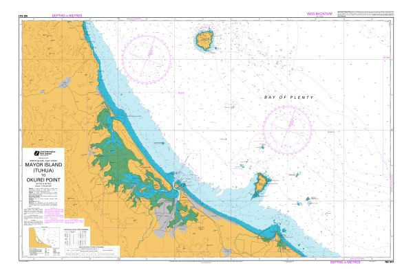
Nautical charts for New Zealand, created by Land Information New Zealand (LINZ), are printed on demand at Stanfords after your order is placed and processed. They provide a detailed coverage of the coastline with a varied range of scales – from overall route planning to detailed harbour charts.Notices to Mariners are available via this link.Source:
CHS Chart 7941 – Nansen Sound and Greely Fiord
Plan included:Canon Fiord 1:300,000The official Canadian charts provide an excellent range of scales for the whole length of Canada`s coastline as well as the Grat Lakes and comply with Safety of Life at Sea (SOLAS) regulations. PLEASE NOTE: Canadian Hydrographic Service charts are ordered on demand, please allow 1-2 weeks for the order to arrive
NZ55 Cape Runaway to Kahutara Point
Plan included:Ranfurly Bank 1:70,000Nautical charts for New Zealand, created by Land Information New Zealand (LINZ), are printed on demand at Stanfords after your order is placed and processed. They provide a detailed coverage of the coastline with a varied range of scales – from overall route planning to detailed harbour charts.Notices to Mariners are available
SHOM Chart 7091 – Abords de Toulon
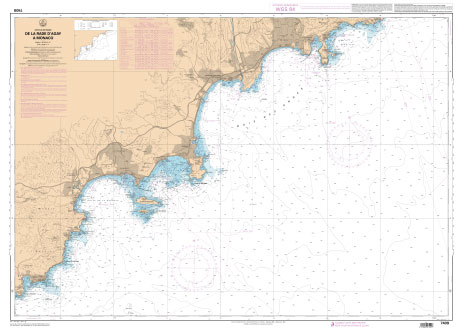
PLEASE NOTE: the chart will be ordered for you if not currently in stock. Please allow 1-2 weeks for the chart to reach Stanfords. SHOM charts are produced by the French Government and comply with Safety of Life at Sea (SOLAS) regulations. They are ideal for professional, commercial and recreational use. Charts within the series
NZ56 Kahutara Point to Blackhead Point
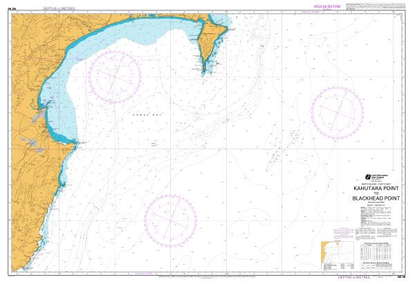
Nautical charts for New Zealand, created by Land Information New Zealand (LINZ), are printed on demand at Stanfords after your order is placed and processed. They provide a detailed coverage of the coastline with a varied range of scales – from overall route planning to detailed harbour charts.Notices to Mariners are available via this link.Source:
SHOM Chart 7091L – Abords de Toulon – Leisure A4 size
LEISURE FORMAT – FOLDED TO A4 SIZE AND PRINTED ON WATER RESISTANT PAPER.PLEASE NOTE: the chart will be ordered for you if not currently in stock. Please allow 1-2 weeks for the chart to reach Stanfords. SHOM charts are produced by the French Government and comply with Safety of Life at Sea (SOLAS) regulations. They
NZ57 Blackhead Point to Castlepoint
Plan included:Castlepoint Anchorage 1:15,000Nautical charts for New Zealand, created by Land Information New Zealand (LINZ), are printed on demand at Stanfords after your order is placed and processed. They provide a detailed coverage of the coastline with a varied range of scales – from overall route planning to detailed harbour charts.Notices to Mariners are available
SHOM Chart 7093 – Rade de Toulon

PLEASE NOTE: the chart will be ordered for you if not currently in stock. Please allow 1-2 weeks for the chart to reach Stanfords. SHOM charts are produced by the French Government and comply with Safety of Life at Sea (SOLAS) regulations. They are ideal for professional, commercial and recreational use. Charts within the series
NZ58 Castlepoint to Cape Palliser, Matakitakiakupe
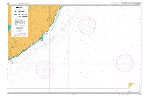
Nautical charts for New Zealand, created by Land Information New Zealand (LINZ), are printed on demand at Stanfords after your order is placed and processed. They provide a detailed coverage of the coastline with a varied range of scales – from overall route planning to detailed harbour charts.Notices to Mariners are available via this link.Source:
SHOM Chart 7093L – Rade de Toulon – Leisure A4 size
LEISURE FORMAT – FOLDED TO A4 SIZE AND PRINTED ON WATER RESISTANT PAPER.PLEASE NOTE: the chart will be ordered for you if not currently in stock. Please allow 1-2 weeks for the chart to reach Stanfords. SHOM charts are produced by the French Government and comply with Safety of Life at Sea (SOLAS) regulations. They
SHOM Chart 7205 – Golfe de La Napoule – Golfe Juan – Iles de Lรฉrins – Abords de Cannes
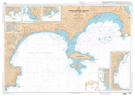
PLEASE NOTE: the chart will be ordered for you if not currently in stock. Please allow 1-2 weeks for the chart to reach Stanfords. SHOM charts are produced by the French Government and comply with Safety of Life at Sea (SOLAS) regulations. They are ideal for professional, commercial and recreational use. Charts within the series
SHOM Chart 7205L – Golfe de La Napoule – Golfe Juan – Iles de Lรฉrins – Abords de Cannes – Leisure A4 size

LEISURE FORMAT – FOLDED TO A4 SIZE AND PRINTED ON WATER RESISTANT PAPER.PLEASE NOTE: the chart will be ordered for you if not currently in stock. Please allow 1-2 weeks for the chart to reach Stanfords. SHOM charts are produced by the French Government and comply with Safety of Life at Sea (SOLAS) regulations. They
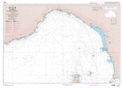
SHOM Chart 7229 – De Nice ร Piombino

PLEASE NOTE: the chart will be ordered for you if not currently in stock. Please allow 1-2 weeks for the chart to reach Stanfords. SHOM charts are produced by the French Government and comply with Safety of Life at Sea (SOLAS) regulations. They are ideal for professional, commercial and recreational use. Charts within the series
SHOM Chart 7229L – De Nice ร Piombino – Leisure A4 size
LEISURE FORMAT – FOLDED TO A4 SIZE AND PRINTED ON WATER RESISTANT PAPER.PLEASE NOTE: the chart will be ordered for you if not currently in stock. Please allow 1-2 weeks for the chart to reach Stanfords. SHOM charts are produced by the French Government and comply with Safety of Life at Sea (SOLAS) regulations. They
SHOM Chart 7406L – De Marseille ร Toulon – Leisure A4 size

LEISURE FORMAT – FOLDED TO A4 SIZE AND PRINTED ON WATER RESISTANT PAPER.PLEASE NOTE: the chart will be ordered for you if not currently in stock. Please allow 1-2 weeks for the chart to reach Stanfords. SHOM charts are produced by the French Government and comply with Safety of Life at Sea (SOLAS) regulations. They
SHOM Chart 7406 – De Marseille ร Toulon
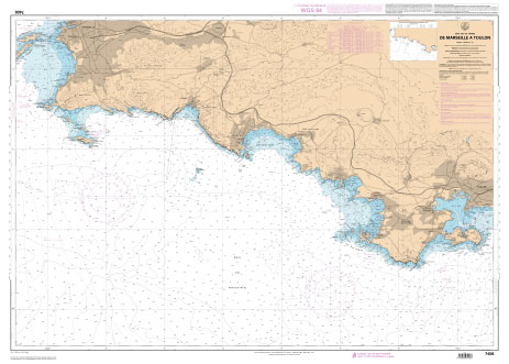
PLEASE NOTE: the chart will be ordered for you if not currently in stock. Please allow 1-2 weeks for the chart to reach Stanfords. SHOM charts are produced by the French Government and comply with Safety of Life at Sea (SOLAS) regulations. They are ideal for professional, commercial and recreational use. Charts within the series