Category Archives: Travel Guides
NZ5412 Port of Tauranga
Plan included:Western Channel (Continuation) 1:10,000Nautical charts for New Zealand, created by Land Information New Zealand (LINZ), are printed on demand at Stanfords after your order is placed and processed. They provide a detailed coverage of the coastline with a varied range of scales – from overall route planning to detailed harbour charts.Notices to Mariners are
NZ5413 Approaches to Tauranga
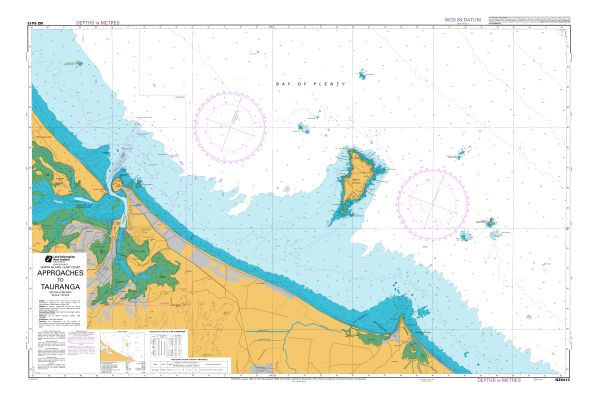
Nautical charts for New Zealand, created by Land Information New Zealand (LINZ), are printed on demand at Stanfords after your order is placed and processed. They provide a detailed coverage of the coastline with a varied range of scales – from overall route planning to detailed harbour charts.Notices to Mariners are available via this link.Source:
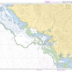
NZ5423 Approaches to Whakaari / White Island
Nautical charts for New Zealand, created by Land Information New Zealand (LINZ), are printed on demand at Stanfords after your order is placed and processed. They provide a detailed coverage of the coastline with a varied range of scales – from overall route planning to detailed harbour charts.Notices to Mariners are available via this link.Source:
NZ5571 Poverty Bay and Approaches to Gisborne
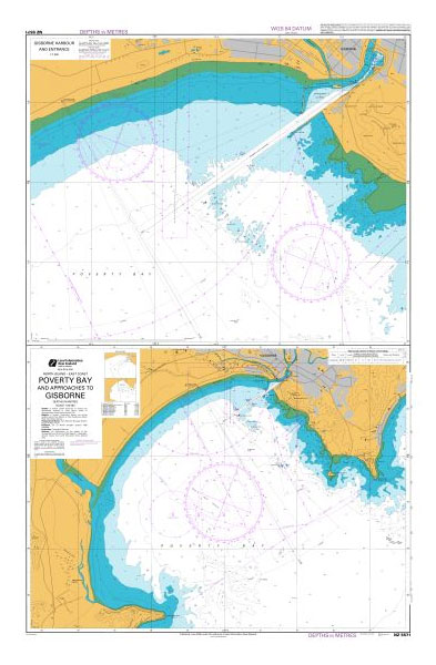
Nautical charts for New Zealand, created by Land Information New Zealand (LINZ), are printed on demand at Stanfords after your order is placed and processed. They provide a detailed coverage of the coastline with a varied range of scales – from overall route planning to detailed harbour charts.Notices to Mariners are available via this link.Source:
NZ5612 Napier Roads
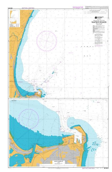
Nautical charts for New Zealand, created by Land Information New Zealand (LINZ), are printed on demand at Stanfords after your order is placed and processed. They provide a detailed coverage of the coastline with a varied range of scales – from overall route planning to detailed harbour charts.Notices to Mariners are available via this link.Source:
NZ443 Approaches to Port Taranaki
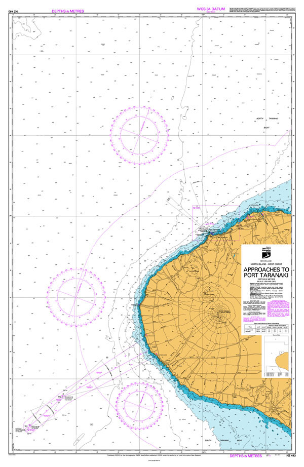
Nautical charts for New Zealand, created by Land Information New Zealand (LINZ), are printed on demand at Stanfords after your order is placed and processed. They provide a detailed coverage of the coastline with a varied range of scales – from overall route planning to detailed harbour charts.Notices to Mariners are available via this link.Source:
NZ4424 Taharoa Offshore Terminal
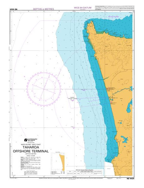
Nautical charts for New Zealand, created by Land Information New Zealand (LINZ), are printed on demand at Stanfords after your order is placed and processed. They provide a detailed coverage of the coastline with a varied range of scales – from overall route planning to detailed harbour charts.Notices to Mariners are available via this link.Source:
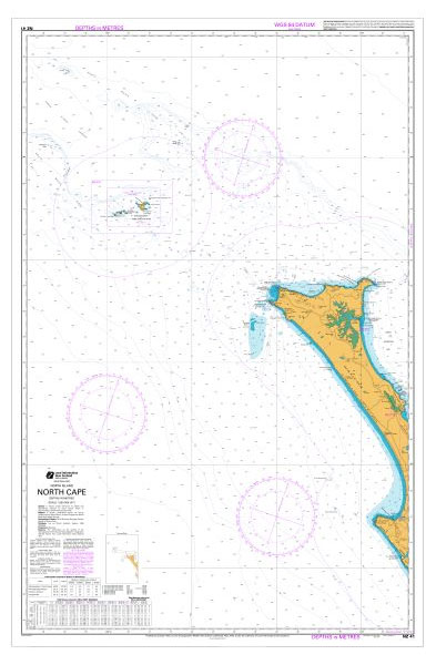
NZ512 Cape Karikari to Cape Brett
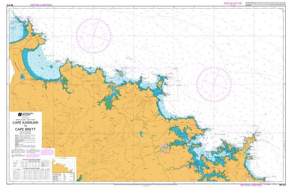
Nautical charts for New Zealand, created by Land Information New Zealand (LINZ), are printed on demand at Stanfords after your order is placed and processed. They provide a detailed coverage of the coastline with a varied range of scales – from overall route planning to detailed harbour charts.Notices to Mariners are available via this link.Source:
NZ521 Cape Brett to Paepae-o-Tu / Bream Tail
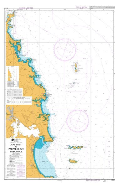
Nautical charts for New Zealand, created by Land Information New Zealand (LINZ), are printed on demand at Stanfords after your order is placed and processed. They provide a detailed coverage of the coastline with a varied range of scales – from overall route planning to detailed harbour charts.Notices to Mariners are available via this link.Source:
NZ522 Paepae-o-Tu / Bream Tail to Kawau Island including Great Barrier Island (Aotea Island)
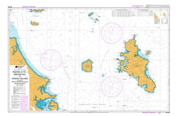
Nautical charts for New Zealand, created by Land Information New Zealand (LINZ), are printed on demand at Stanfords after your order is placed and processed. They provide a detailed coverage of the coastline with a varied range of scales – from overall route planning to detailed harbour charts.Notices to Mariners are available via this link.Source:
NZ531 Great Barrier Island (Aotea Island) to Mercury Bay
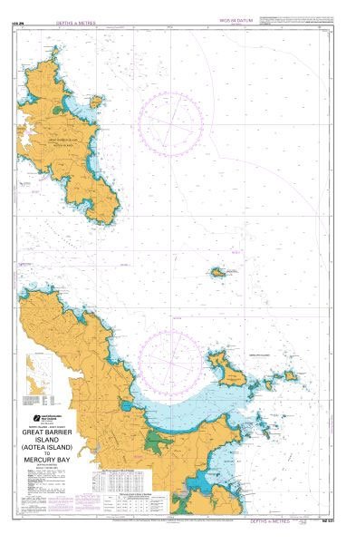
Nautical charts for New Zealand, created by Land Information New Zealand (LINZ), are printed on demand at Stanfords after your order is placed and processed. They provide a detailed coverage of the coastline with a varied range of scales – from overall route planning to detailed harbour charts.Notices to Mariners are available via this link.Source:
NZ532 Approaches to Auckland
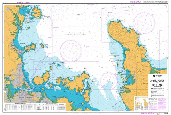
Nautical charts for New Zealand, created by Land Information New Zealand (LINZ), are printed on demand at Stanfords after your order is placed and processed. They provide a detailed coverage of the coastline with a varied range of scales – from overall route planning to detailed harbour charts.Notices to Mariners are available via this link.Source:
NZ533 Firth of Thames
Nautical charts for New Zealand, created by Land Information New Zealand (LINZ), are printed on demand at Stanfords after your order is placed and processed. They provide a detailed coverage of the coastline with a varied range of scales – from overall route planning to detailed harbour charts.Notices to Mariners are available via this link.Source:
NZ534 Mercury Bay to Katikati Entrance
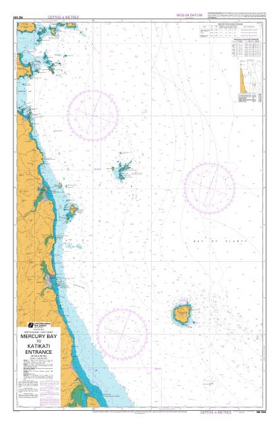
Nautical charts for New Zealand, created by Land Information New Zealand (LINZ), are printed on demand at Stanfords after your order is placed and processed. They provide a detailed coverage of the coastline with a varied range of scales – from overall route planning to detailed harbour charts.Notices to Mariners are available via this link.Source:
NZ541 Mayor Island (Tuhua) to Okurei Point
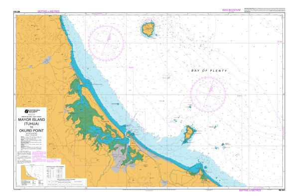
Nautical charts for New Zealand, created by Land Information New Zealand (LINZ), are printed on demand at Stanfords after your order is placed and processed. They provide a detailed coverage of the coastline with a varied range of scales – from overall route planning to detailed harbour charts.Notices to Mariners are available via this link.Source:
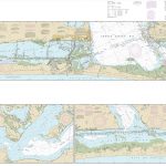
NZ542 Motiti Island to Pehitairi Point
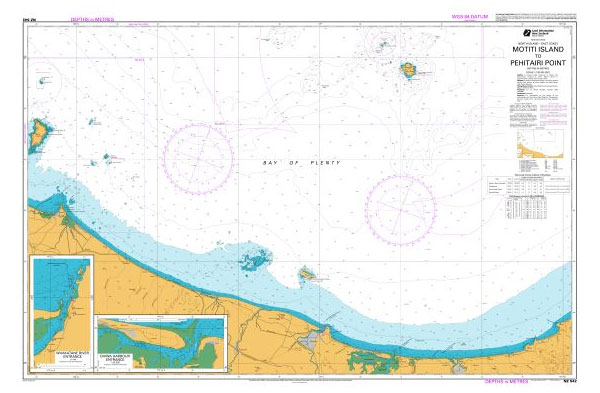
Plans included:Ohiwa Harbour Entrance 1:25,000Whakatane River Entrance 1:7,000Nautical charts for New Zealand, created by Land Information New Zealand (LINZ), are printed on demand at Stanfords after your order is placed and processed. They provide a detailed coverage of the coastline with a varied range of scales – from overall route planning to detailed harbour charts.Notices
NZ561 Approaches to Napier
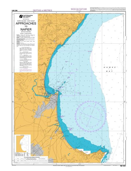
Nautical charts for New Zealand, created by Land Information New Zealand (LINZ), are printed on demand at Stanfords after your order is placed and processed. They provide a detailed coverage of the coastline with a varied range of scales – from overall route planning to detailed harbour charts.Notices to Mariners are available via this link.Source:
NZ4111 Manawatawhi / Three Kings Islands
Plans included:North West Bay 1:6,000South East Bay 1:6,000Nautical charts for New Zealand, created by Land Information New Zealand (LINZ), are printed on demand at Stanfords after your order is placed and processed. They provide a detailed coverage of the coastline with a varied range of scales – from overall route planning to detailed harbour charts.Notices
NZ4212 Hokianga Harbour
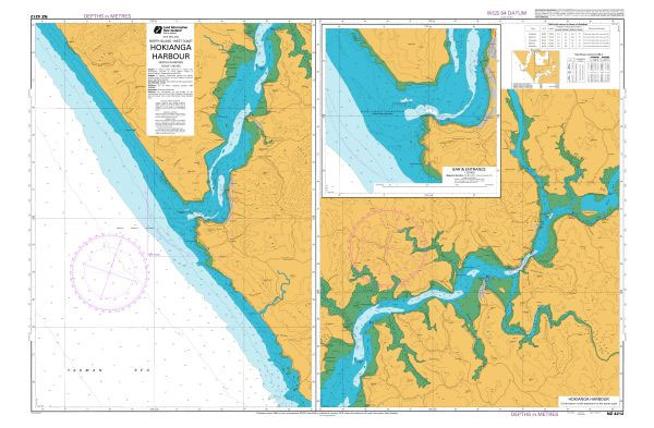
Plans included:Hokianga Harbour (Continuation) 1:40,000Bar & Entrance 1:20,000Nautical charts for New Zealand, created by Land Information New Zealand (LINZ), are printed on demand at Stanfords after your order is placed and processed. They provide a detailed coverage of the coastline with a varied range of scales – from overall route planning to detailed harbour charts.Notices
SHOM Chart 6942 – De Punta d’Orchina au Cap Muro – Abords d’Ajaccio
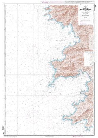
PLEASE NOTE: the chart will be ordered for you if not currently in stock. Please allow 1-2 weeks for the chart to reach Stanfords. SHOM charts are produced by the French Government and comply with Safety of Life at Sea (SOLAS) regulations. They are ideal for professional, commercial and recreational use. Charts within the series