Category Archives: Travel Guides
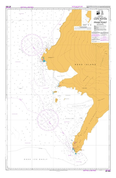
NZ14901 Cape Royds to Pram Point
Nautical charts for New Zealand, created by Land Information New Zealand (LINZ), are printed on demand at Stanfords after your order is placed and processed. They provide a detailed coverage of the coastline with a varied range of scales – from overall route planning to detailed harbour charts.Notices to Mariners are available via this link.Source:
NZ14903 Approaches to Scott Island
Plan included:Scott Island 1:25,000Nautical charts for New Zealand, created by Land Information New Zealand (LINZ), are printed on demand at Stanfords after your order is placed and processed. They provide a detailed coverage of the coastline with a varied range of scales – from overall route planning to detailed harbour charts.Notices to Mariners are available
NZ14906 Cape Adere and Cape Hallett

Plan included:Cape Adare 1:50,000Cape Hallett 1:50,000Seabee Hook 1:15,000Ridley Beach 1:15,000Nautical charts for New Zealand, created by Land Information New Zealand (LINZ), are printed on demand at Stanfords after your order is placed and processed. They provide a detailed coverage of the coastline with a varied range of scales – from overall route planning to detailed
NZ14907 Possession Islands
Nautical charts for New Zealand, created by Land Information New Zealand (LINZ), are printed on demand at Stanfords after your order is placed and processed. They provide a detailed coverage of the coastline with a varied range of scales – from overall route planning to detailed harbour charts.Notices to Mariners are available via this link.Source:
NZ2863 Approaches to Waitangi

Plans included:Port Hutt 1:10,000Ocean Bay 1:12,500Nautical charts for New Zealand, created by Land Information New Zealand (LINZ), are printed on demand at Stanfords after your order is placed and processed. They provide a detailed coverage of the coastline with a varied range of scales – from overall route planning to detailed harbour charts.Notices to Mariners
NZ681 Approaches to Bluff and Riverton / Aparima
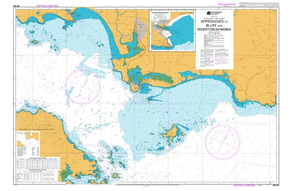
Plan included:Riverton / Aparima 1:40,000Nautical charts for New Zealand, created by Land Information New Zealand (LINZ), are printed on demand at Stanfords after your order is placed and processed. They provide a detailed coverage of the coastline with a varied range of scales – from overall route planning to detailed harbour charts.Notices to Mariners are
NZ5323 Auckland Harbour West
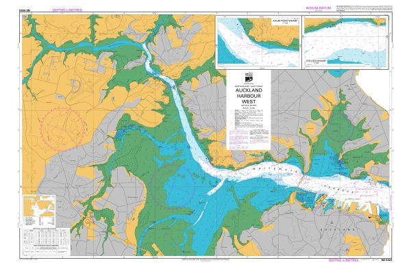
Plans included:Chelsea Wharf 1:7,500Kauri Point Wharf 1:7,500Nautical charts for New Zealand, created by Land Information New Zealand (LINZ), are printed on demand at Stanfords after your order is placed and processed. They provide a detailed coverage of the coastline with a varied range of scales – from overall route planning to detailed harbour charts.Notices to
NZ69 Stewart Island / Rakiura
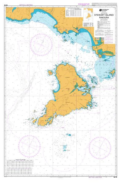
Nautical charts for New Zealand, created by Land Information New Zealand (LINZ), are printed on demand at Stanfords after your order is placed and processed. They provide a detailed coverage of the coastline with a varied range of scales – from overall route planning to detailed harbour charts.Notices to Mariners are available via this link.Source:
NZ5113 Plans in Rangaunu Bay
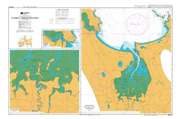
Plans included:Awanui River 1:20,000Rangaunu Bay and Awanui River Approaches 1:50,000Houhora Harbour 1:25,000Nautical charts for New Zealand, created by Land Information New Zealand (LINZ), are printed on demand at Stanfords after your order is placed and processed. They provide a detailed coverage of the coastline with a varied range of scales – from overall route planning
NZ76 Western Approaches to Foveaux Strait
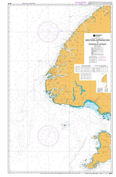
Nautical charts for New Zealand, created by Land Information New Zealand (LINZ), are printed on demand at Stanfords after your order is placed and processed. They provide a detailed coverage of the coastline with a varied range of scales – from overall route planning to detailed harbour charts.Notices to Mariners are available via this link.Source:
NZ5111 Plans between Parengarenga and Whangaruru
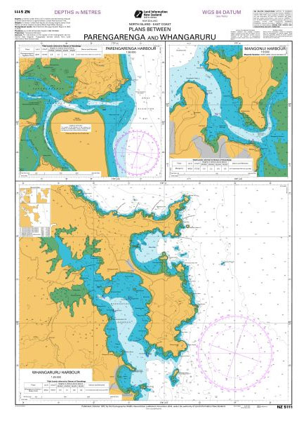
Plans included:Whangaruru Harbour 1:25,000Parengarenga Harbour 1:36,000Mangonui Harbour 1:9,000Nautical charts for New Zealand, created by Land Information New Zealand (LINZ), are printed on demand at Stanfords after your order is placed and processed. They provide a detailed coverage of the coastline with a varied range of scales – from overall route planning to detailed harbour charts.Notices
NZ252 Lake Wakatipu
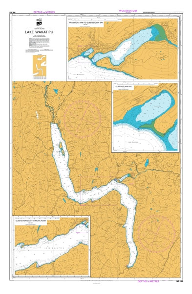
Plans included:Queenstown Bay to Picnic Point 1:50,000Frankton Arm to Queenstown Bay 1:20,000Queenstown Bay 1:5,000Nautical charts for New Zealand, created by Land Information New Zealand (LINZ), are printed on demand at Stanfords after your order is placed and processed. They provide a detailed coverage of the coastline with a varied range of scales – from overall
NZ5328 Coromandel Harbour
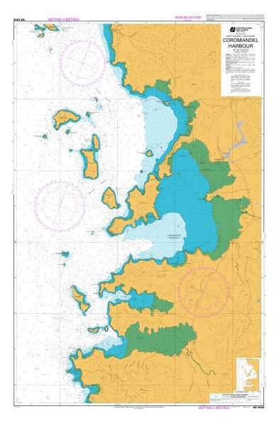
Nautical charts for New Zealand, created by Land Information New Zealand (LINZ), are printed on demand at Stanfords after your order is placed and processed. They provide a detailed coverage of the coastline with a varied range of scales – from overall route planning to detailed harbour charts.Notices to Mariners are available via this link.Source:
NZ73 Abut Head to Milford Sound
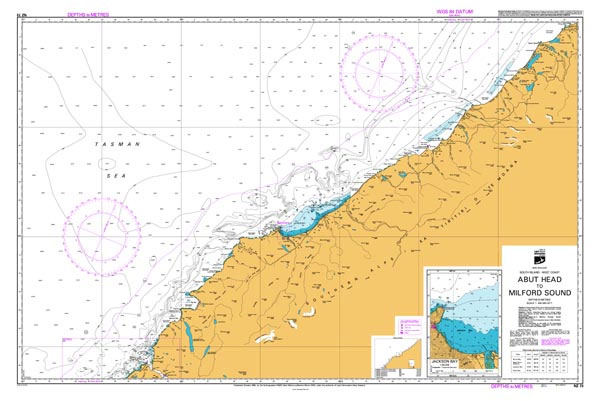
Plan included:Jackson Bay 1:50,000Nautical charts for New Zealand, created by Land Information New Zealand (LINZ), are printed on demand at Stanfords after your order is placed and processed. They provide a detailed coverage of the coastline with a varied range of scales – from overall route planning to detailed harbour charts.Notices to Mariners are available
NZ5316 Whitianga Harbour
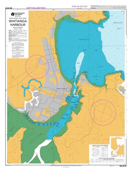
Nautical charts for New Zealand, created by Land Information New Zealand (LINZ), are printed on demand at Stanfords after your order is placed and processed. They provide a detailed coverage of the coastline with a varied range of scales – from overall route planning to detailed harbour charts.Notices to Mariners are available via this link.Source:
NZ2325 Plans in Lake Taupo (Taupomoana)

Plans included:Western Bay 1:40,000Waihi Bay 1:20,000Motuoapa Bay 1:10,000Boat Harbour Kawakawa Point 1:5,000Nautical charts for New Zealand, created by Land Information New Zealand (LINZ), are printed on demand at Stanfords after your order is placed and processed. They provide a detailed coverage of the coastline with a varied range of scales – from overall route planning
NZ463 Approaches to Wellington

Nautical charts for New Zealand, created by Land Information New Zealand (LINZ), are printed on demand at Stanfords after your order is placed and processed. They provide a detailed coverage of the coastline with a varied range of scales – from overall route planning to detailed harbour charts.Notices to Mariners are available via this link.Source:
NZ61 Karamea River to Stephens Island (Takapourewa)
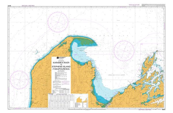
Nautical charts for New Zealand, created by Land Information New Zealand (LINZ), are printed on demand at Stanfords after your order is placed and processed. They provide a detailed coverage of the coastline with a varied range of scales – from overall route planning to detailed harbour charts.Notices to Mariners are available via this link.Source:
NZ614 Tasman Bay / Te Tai-o-Aorere
Plans included:Port Motueka 1:20,000Mapua 1:20,000Nautical charts for New Zealand, created by Land Information New Zealand (LINZ), are printed on demand at Stanfords after your order is placed and processed. They provide a detailed coverage of the coastline with a varied range of scales – from overall route planning to detailed harbour charts.Notices to Mariners are
NZ615 Marlborough Sounds
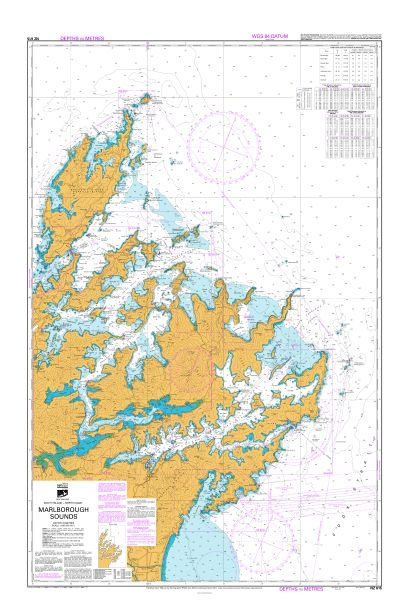
Nautical charts for New Zealand, created by Land Information New Zealand (LINZ), are printed on demand at Stanfords after your order is placed and processed. They provide a detailed coverage of the coastline with a varied range of scales – from overall route planning to detailed harbour charts.Notices to Mariners are available via this link.Source: