Category Archives: Non-Fiction & Reference
NP205 Tide Tables – South China Sea and Indonesia 2021
Worldwide tidal height information, revised annually for greater accuracy, makes it easier to plan your departaure and arrival times.The tables include daily high and low-water times and heights for standard ports, times and height differences for secondary ports and harmonic constants for all ports where they are known.This area was previously included in NP203.
NP206 Tide Tables – North Pacific Ocean 2021

NEW EDITION OUT ON 08/10/2020Worldwide tidal height information, revised annually for greater accuracy, makes it easier to plan your departaure and arrival times.The tables include daily high and low-water times and heights for standard ports, times and height differences for secondary ports and harmonic constants for all ports where they are known.
NP208 Tide Tables – South East Atlantic Ocean 2021
Worldwide tidal height information, revised annually for greater accuracy, makes it easier to plan your departaure and arrival times.The tables include daily high and low-water times and heights for standard ports, times and height differences for secondary ports and harmonic constants for all ports where they are known.
NP201B Tide Tables – United Kingdom and Ireland 2022
AVAILABLE FROM 03/06/2021Admiralty Tide Tables – United Kingdom and IrelandExcluding Isles of Scilly, English Channel to River Humber,Channel Islands and European Channel Ports.Worldwide tidal height information, revised annually for greater accuracy, makes it easier to plan your departaure and arrival times.The tables include daily high and low-water times and heights for standard ports, times and
NP203 Tide Tables – Indian Ocean 2019
2020 EDITION OUT ON 18/07/2019Worldwide tidal height information, revised annually for greater accuracy, makes it easier to plan your departaure and arrival times.The tables include daily high and low-water times and heights for standard ports, times and height differences for secondary ports and harmonic constants for all ports where they are known.
NP202 Tide Tables – North Atlantic Ocean and Arctic Regions 2022
2022 EDITION WILL BE PUBLISHED ON 17/06/2021Excludes United Kingdom which is covered by NP201A and NP201B Tide Tables.Worldwide tidal height information, revised annually for greater accuracy, makes it easier to plan your departaure and arrival times.The tables include daily high and low-water times and heights for standard ports, times and height differences for secondary ports
NP204 Tide Tables – South Pacific Ocean 2019
NEW (2020) EDITION OUT 15/08/2019Worldwide tidal height information, revised annually for greater accuracy, makes it easier to plan your departaure and arrival times.The tables include daily high and low-water times and heights for standard ports, times and height differences for secondary ports and harmonic constants for all ports where they are known.
NP203 Tide Tables – Indian Ocean 2022
Worldwide tidal height information, revised annually for greater accuracy, makes it easier to plan your departaure and arrival times.The tables include daily high and low-water times and heights for standard ports, times and height differences for secondary ports and harmonic constants for all ports where they are known.
NP205 Tide Tables – South China Sea and Indonesia 2019
Worldwide tidal height information, revised annually for greater accuracy, makes it easier to plan your departaure and arrival times.The tables include daily high and low-water times and heights for standard ports, times and height differences for secondary ports and harmonic constants for all ports where they are known.This area was previously included in NP203.
NP204 Tide Tables – South Pacific Ocean 2022
Worldwide tidal height information, revised annually for greater accuracy, makes it easier to plan your departaure and arrival times.The tables include daily high and low-water times and heights for standard ports, times and height differences for secondary ports and harmonic constants for all ports where they are known.
The Brooklyn Nobody Knows: An Urban Walking Guide

Bill Helmreich walked every block of New York City–6,000 miles in all–to write the award-winning `The New York Nobody Knows`. Now he has re-walked Brooklyn–some 816 miles–to write this one-of-a-kind walking guide to the city`s hottest borough. Drawing on hundreds of conversations he had with residents during his block-by-block journeys, `The Brooklyn Nobody Knows` captures
The Manhattan Nobody Knows: An Urban Walking Guide

A unique walking guide to Manhattan, from the author of `The New York Nobody Knows`Bill Helmreich walked every block of New York City–six-thousand miles in all–to write the award-winning `The New York Nobody Knows`. Now he has re-walked most of Manhattan–721 miles–to write this new, one-of-a-kind walking guide to the heart of one of the
White Bull On The Highway
This little photographic guide has been conceived for the curious and discerning traveler, who is looking to explore the mesmerising landscapes and authentic life on the island of Eleuthera. With inspiring images and essential notes on discovering for yourself some of Eleuthera’s little-known gems, this book opens doors to warm island connections, truly untamed beauty,
Daghestan – Tradition & Survival

Daghestan is home to more than 30 distinct peoples. Each has their own language yet they share a surprisingly homogeneous culture that has both withstood and absorbed centuries of external influences. A fascinating account of change and adaptation in the villages of this area.
Azerbaijan Phrase Book

This dictionary and phrasebook includes a dictionary of over 4,000 entries, plus an introduction to basic grammar and helpful phrasebook chapters covering subjects such as etiquette, the office, government, and food and drink. It is written entirely in the Roman alphabet. This unique language guides for getting around and communicating easily in everyday situations will
NP220 Tidal Stream Atlas Rosyth Harbour and Approaches
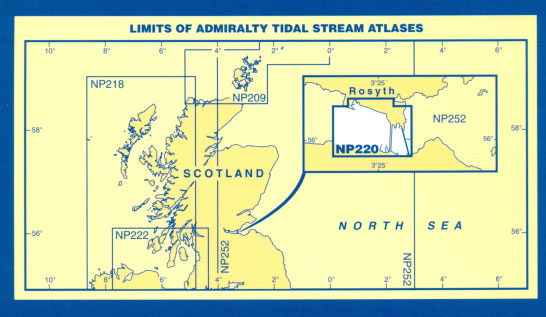
Tidal Stream Atlas 220 covers Rosyth Harbour and Approaches.Tidal stream atlases show, in diagrammatic form, the major tidal streams for selected waters of NW Europe. They show, at a glance, both direction and rate of tidal streams at hourly intervals by careful and accurate use of graded arrows. They also display mean neap and spring
NP222 Tidal Stream Atlas Firth of Clyde

The Admiralty Tidal Stream Atlas: Firth Clyde and Approaches contains a set of thirteen charts showing tidal streams at hourly intervals from six hours before to six hours after HW Dover. It also includes eight plans of Rathlin Island and Sound, showing tidal streams at varying intervals from five hours before to six hours after
NP257 Tidal Stream Atlas Portland
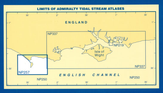
Tidal Stream Atlas 257 covers the approaches to Portland.Tidal stream atlases show, in diagrammatic form, the major tidal streams for selected waters of NW Europe. They show, at a glance, both direction and rate of tidal streams at hourly intervals by careful and accurate use of graded arrows. They also display mean neap and spring
NP233 Tidal Stream Atlas Dover Strait

Tidal Stream Atlas 233 covers the Dover Strait.Tidal stream atlases show, in diagrammatic form, the major tidal streams for selected waters of NW Europe. They show, at a glance, both direction and rate of tidal streams at hourly intervals by careful and accurate use of graded arrows. They also display mean neap and spring tidal
The Russian Way

Here`s an up to the minute, insider`s look at how Russians live and work and how they feel about everything from family to religion to entertainment. “Explore The Russian Way” of doing things, and you`ll uncover a fascinating world imbued with kindness, generosity, superstition, and surprises. Russian character comes to life as you follow favourite