Category Archives: Maps
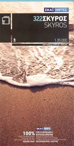
Skyros Terrain Editions 322

Skyros at 1:35,000 on a contoured, GPS compatible hiking map published by Terrain Cartography group together with Skai Maps, and printed on light, waterproof and tear-resistant Polyart plastic paper, with extensive tourist information.Topography is very well presented by contours, enhanced by spot heights, subtle relief shading and additional altitude colouring. Contour interval, unless indicated below
Pogradeci Prefecture

Pogradeci Prefecture at 1:100,000 in a series of handy size, waterproof and tear-resistant, contoured and GPS compatible road maps from the Tirana-based publishers Vektor. Landscape is presented by altitude colouring and contours lines at 100m intervals, with spot heights and a few more names of topographic features than found on Vektor’s 200K road maps of
Puka Prefecture

Puka Prefecture at 1:110,000 in a series of handy size, waterproof and tear-resistant, contoured and GPS compatible road maps from the Tirana-based publishers Vektor. Landscape is presented by altitude colouring and contours lines at 100m intervals, with spot heights and a few more names of topographic features than found on Vektor’s 200K road maps of
Saranda Prefecture

Saranda Prefecture at 1:120,000 in a series of handy size, waterproof and tear-resistant, contoured and GPS compatible road maps from the Tirana-based publishers Vektor. Landscape is presented by altitude colouring and contours lines at 100m intervals, with spot heights and a few more names of topographic features than found on Vektor’s 200K road maps of
Skrapari Prefecture

Skrapari Prefecture at 1:100,000 in a series of handy size, waterproof and tear-resistant, contoured and GPS compatible road maps from the Tirana-based publishers Vektor. Landscape is presented by altitude colouring and contours lines at 100m intervals, with spot heights and a few more names of topographic features than found on Vektor’s 200K road maps of
Shkodra Prefecture

Shkodra Prefecture at 1:150,000 in a series of handy size, waterproof and tear-resistant, contoured and GPS compatible road maps from the Tirana-based publishers Vektor. Landscape is presented by altitude colouring and contours lines at 100m intervals, with spot heights and a few more names of topographic features than found on Vektor’s 200K road maps of
Tepelena Prefecture

Tepelena Prefecture at 1:90,000 in a series of handy size, waterproof and tear-resistant, contoured and GPS compatible road maps from the Tirana-based publishers Vektor. Landscape is presented by altitude colouring and contours lines at 100m intervals, with spot heights and a few more names of topographic features than found on Vektor’s 200K road maps of
Tirana Prefecture

Tirana Prefecture at 1:130,000 in a series of handy size, waterproof and tear-resistant, contoured and GPS compatible road maps from the Tirana-based publishers Vektor. Landscape is presented by altitude colouring and contours lines at 100m intervals, with spot heights and a few more names of topographic features than found on Vektor’s 200K road maps of


