Category Archives: Maps
Mondonedo CNIG Topo 24
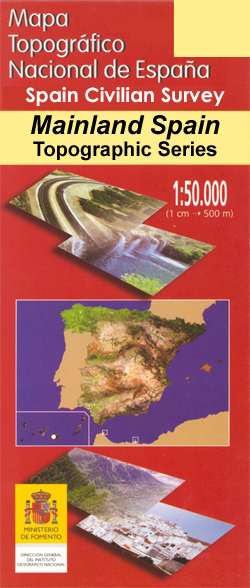
Topographic coverage of mainland Spain at 1:50,000 in the MTN50 (Mapa Topogrรกfico Nacional) series from the Centro Nacional de Informaciรณn Geografica, the country’s civilian survey organization. The maps have contours at 20m intervals, enhanced by relief shading, plus colouring and/or graphics to show different types of terrain, vegetation or land use. Boundaries of national parks

Vegadeo CNIG Topo 25
Topographic coverage of mainland Spain at 1:50,000 in the MTN50 (Mapa Topogrรกfico Nacional) series from the Centro Nacional de Informaciรณn Geografica, the country’s civilian survey organization. The maps have contours at 20m intervals, enhanced by relief shading, plus colouring and/or graphics to show different types of terrain, vegetation or land use. Boundaries of national parks
Boal CNIG Topo 26
Topographic coverage of mainland Spain at 1:50,000 in the MTN50 (Mapa Topogrรกfico Nacional) series from the Centro Nacional de Informaciรณn Geografica, the country’s civilian survey organization. The maps have contours at 20m intervals, enhanced by relief shading, plus colouring and/or graphics to show different types of terrain, vegetation or land use. Boundaries of national parks
Tineo CNIG Topo 27
Topographic coverage of mainland Spain at 1:50,000 in the MTN50 (Mapa Topogrรกfico Nacional) series from the Centro Nacional de Informaciรณn Geografica, the country’s civilian survey organization. The maps have contours at 20m intervals, enhanced by relief shading, plus colouring and/or graphics to show different types of terrain, vegetation or land use. Boundaries of national parks
Grado CNIG Topo 28
Topographic coverage of mainland Spain at 1:50,000 in the MTN50 (Mapa Topogrรกfico Nacional) series from the Centro Nacional de Informaciรณn Geografica, the country’s civilian survey organization. The maps have contours at 20m intervals, enhanced by relief shading, plus colouring and/or graphics to show different types of terrain, vegetation or land use. Boundaries of national parks
Villaviciosa CNIG Topo 30

Topographic coverage of mainland Spain at 1:50,000 in the MTN50 (Mapa Topogrรกfico Nacional) series from the Centro Nacional de Informaciรณn Geografica, the country’s civilian survey organization. The maps have contours at 20m intervals, enhanced by relief shading, plus colouring and/or graphics to show different types of terrain, vegetation or land use. Boundaries of national parks
Comillas CNIG Topo 33

Topographic coverage of mainland Spain at 1:50,000 in the MTN50 (Mapa Topogrรกfico Nacional) series from the Centro Nacional de Informaciรณn Geografica, the country’s civilian survey organization. The maps have contours at 20m intervals, enhanced by relief shading, plus colouring and/or graphics to show different types of terrain, vegetation or land use. Boundaries of national parks
Torrelavega CNIG Topo 34

Topographic coverage of mainland Spain at 1:50,000 in the MTN50 (Mapa Topogrรกfico Nacional) series from the Centro Nacional de Informaciรณn Geografica, the country’s civilian survey organization. The maps have contours at 20m intervals, enhanced by relief shading, plus colouring and/or graphics to show different types of terrain, vegetation or land use. Boundaries of national parks
Santander CNIG Topo 35
Topographic coverage of mainland Spain at 1:50,000 in the MTN50 (Mapa Topogrรกfico Nacional) series from the Centro Nacional de Informaciรณn Geografica, the country’s civilian survey organization. The maps have contours at 20m intervals, enhanced by relief shading, plus colouring and/or graphics to show different types of terrain, vegetation or land use. Boundaries of national parks
Ribera d`Ebre
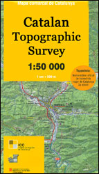
Topographic survey of Catalonia at 1:50,000 from the Institut Cartogrร fic de Catalunya, with vivid presentation of the terrain and an overprint for long-distance GR hiking trails. The series provides an excellent alternative to the much smaller sheets in the civilian or military surveys produced for the whole of Spain. The Catalan 50K series has not
Pla d`Urgell
Topographic survey of Catalonia at 1:50,000 from the Institut Cartogrร fic de Catalunya, with vivid presentation of the terrain and an overprint for long-distance GR hiking trails. The series provides an excellent alternative to the much smaller sheets in the civilian or military surveys produced for the whole of Spain. The Catalan 50K series has not
Priorat
Topographic survey of Catalonia at 1:50,000 from the Institut Cartogrร fic de Catalunya, with vivid presentation of the terrain and an overprint for long-distance GR hiking trails. The series provides an excellent alternative to the much smaller sheets in the civilian or military surveys produced for the whole of Spain. The Catalan 50K series has not
Montsiร
Topographic survey of Catalonia at 1:50,000 from the Institut Cartogrร fic de Catalunya, with vivid presentation of the terrain and an overprint for long-distance GR hiking trails. The series provides an excellent alternative to the much smaller sheets in the civilian or military surveys produced for the whole of Spain. The Catalan 50K series has not
Tarragones
Topographic survey of Catalonia at 1:50,000 from the Institut Cartogrร fic de Catalunya, with vivid presentation of the terrain and an overprint for long-distance GR hiking trails. The series provides an excellent alternative to the much smaller sheets in the civilian or military surveys produced for the whole of Spain. The Catalan 50K series has not
Alt Camp
Topographic survey of Catalonia at 1:50,000 from the Institut Cartogrร fic de Catalunya, with vivid presentation of the terrain and an overprint for long-distance GR hiking trails. The series provides an excellent alternative to the much smaller sheets in the civilian or military surveys produced for the whole of Spain. The Catalan 50K series has not
Baix Penedรจs
Topographic survey of Catalonia at 1:50,000 from the Institut Cartogrร fic de Catalunya, with vivid presentation of the terrain and an overprint for long-distance GR hiking trails. The series provides an excellent alternative to the much smaller sheets in the civilian or military surveys produced for the whole of Spain. The Catalan 50K series has not
Alt Penedรจs
Topographic survey of Catalonia at 1:50,000 from the Institut Cartogrร fic de Catalunya, with vivid presentation of the terrain and an overprint for long-distance GR hiking trails. The series provides an excellent alternative to the much smaller sheets in the civilian or military surveys produced for the whole of Spain. The Catalan 50K series has not
Cariรฑo CNIG Topo 1
Topographic coverage of mainland Spain at 1:50,000 in the MTN50 (Mapa Topogrรกfico Nacional) series from the Centro Nacional de Informaciรณn Geografica, the country’s civilian survey organization. The maps have contours at 20m intervals, enhanced by relief shading, plus colouring and/or graphics to show different types of terrain, vegetation or land use. Boundaries of national parks