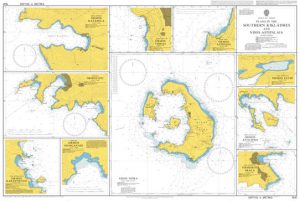
Category Archives: Maps
Potes CNIG Topo 81
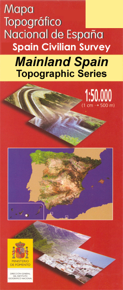
Topographic coverage of mainland Spain at 1:50,000 in the MTN50 (Mapa Topogrรกfico Nacional) series from the Centro Nacional de Informaciรณn Geografica, the country’s civilian survey organization. The maps have contours at 20m intervals, enhanced by relief shading, plus colouring and/or graphics to show different types of terrain, vegetation or land use. Boundaries of national parks
Fisterra CNIG Topo 92
Topographic coverage of mainland Spain at 1:50,000 in the MTN50 (Mapa Topogrรกfico Nacional) series from the Centro Nacional de Informaciรณn Geografica, the country’s civilian survey organization. The maps have contours at 20m intervals, enhanced by relief shading, plus colouring and/or graphics to show different types of terrain, vegetation or land use. Boundaries of national parks
Ansoain CNIG Topo 115
Topographic coverage of mainland Spain at 1:50,000 in the MTN50 (Mapa Topogrรกfico Nacional) series from the Centro Nacional de Informaciรณn Geografica, the country’s civilian survey organization. The maps have contours at 20m intervals, enhanced by relief shading, plus colouring and/or graphics to show different types of terrain, vegetation or land use. Boundaries of national parks
Garralda CNIG Topo 116

Topographic coverage of mainland Spain at 1:50,000 in the MTN50 (Mapa Topogrรกfico Nacional) series from the Centro Nacional de Informaciรณn Geografica, the country’s civilian survey organization. The maps have contours at 20m intervals, enhanced by relief shading, plus colouring and/or graphics to show different types of terrain, vegetation or land use. Boundaries of national parks
Noia CNIG Topo 119
Topographic coverage of mainland Spain at 1:50,000 in the MTN50 (Mapa Topogrรกfico Nacional) series from the Centro Nacional de Informaciรณn Geografica, the country’s civilian survey organization. The maps have contours at 20m intervals, enhanced by relief shading, plus colouring and/or graphics to show different types of terrain, vegetation or land use. Boundaries of national parks
Padrรณn CNIG Topo 120
Topographic coverage of mainland Spain at 1:50,000 in the MTN50 (Mapa Topogrรกfico Nacional) series from the Centro Nacional de Informaciรณn Geografica, the country’s civilian survey organization. The maps have contours at 20m intervals, enhanced by relief shading, plus colouring and/or graphics to show different types of terrain, vegetation or land use. Boundaries of national parks
Vegas del Condado CNIG Topo 130
Topographic coverage of mainland Spain at 1:50,000 in the MTN50 (Mapa Topogrรกfico Nacional) series from the Centro Nacional de Informaciรณn Geografica, the country’s civilian survey organization. The maps have contours at 20m intervals, enhanced by relief shading, plus colouring and/or graphics to show different types of terrain, vegetation or land use. Boundaries of national parks
Miranda de Ebro CNIG Topo 137
Topographic coverage of mainland Spain at 1:50,000 in the MTN50 (Mapa Topogrรกfico Nacional) series from the Centro Nacional de Informaciรณn Geografica, the country’s civilian survey organization. The maps have contours at 20m intervals, enhanced by relief shading, plus colouring and/or graphics to show different types of terrain, vegetation or land use. Boundaries of national parks
Estella / Lizarra CNIG Topo 140
Topographic coverage of mainland Spain at 1:50,000 in the MTN50 (Mapa Topogrรกfico Nacional) series from the Centro Nacional de Informaciรณn Geografica, the country’s civilian survey organization. The maps have contours at 20m intervals, enhanced by relief shading, plus colouring and/or graphics to show different types of terrain, vegetation or land use. Boundaries of national parks
Mondonedo CNIG Topo 24
Topographic coverage of mainland Spain at 1:50,000 in the MTN50 (Mapa Topogrรกfico Nacional) series from the Centro Nacional de Informaciรณn Geografica, the country’s civilian survey organization. The maps have contours at 20m intervals, enhanced by relief shading, plus colouring and/or graphics to show different types of terrain, vegetation or land use. Boundaries of national parks

Vegadeo CNIG Topo 25
Topographic coverage of mainland Spain at 1:50,000 in the MTN50 (Mapa Topogrรกfico Nacional) series from the Centro Nacional de Informaciรณn Geografica, the country’s civilian survey organization. The maps have contours at 20m intervals, enhanced by relief shading, plus colouring and/or graphics to show different types of terrain, vegetation or land use. Boundaries of national parks
Boal CNIG Topo 26
Topographic coverage of mainland Spain at 1:50,000 in the MTN50 (Mapa Topogrรกfico Nacional) series from the Centro Nacional de Informaciรณn Geografica, the country’s civilian survey organization. The maps have contours at 20m intervals, enhanced by relief shading, plus colouring and/or graphics to show different types of terrain, vegetation or land use. Boundaries of national parks
Tineo CNIG Topo 27
Topographic coverage of mainland Spain at 1:50,000 in the MTN50 (Mapa Topogrรกfico Nacional) series from the Centro Nacional de Informaciรณn Geografica, the country’s civilian survey organization. The maps have contours at 20m intervals, enhanced by relief shading, plus colouring and/or graphics to show different types of terrain, vegetation or land use. Boundaries of national parks
Grado CNIG Topo 28
Topographic coverage of mainland Spain at 1:50,000 in the MTN50 (Mapa Topogrรกfico Nacional) series from the Centro Nacional de Informaciรณn Geografica, the country’s civilian survey organization. The maps have contours at 20m intervals, enhanced by relief shading, plus colouring and/or graphics to show different types of terrain, vegetation or land use. Boundaries of national parks