Category Archives: Maps
Rutland Water – Stamford & Oakham OS Explorer Map 234 (paper)

Rutland Water, Stamford and Oakham area on a detailed topographic and GPS compatible map No. 234, paper version, from the Ordnance Survey’s 1:25,000 Explorer series. MOBILE DOWNLOADS: this title and all the other OS Explorer maps include a code for downloading after purchase the digital version onto your smartphone or tablet for viewing on the
Wisbech & Peterborough North – Market Deeping & Crowland OS Explorer Map 235 (paper)

Wisbech, Peterborough North, Market Deeping and Crowland area on a detailed topographic and GPS compatible map No. 235, paper version, from the Ordnance Survey’s 1:25,000 Explorer series.MOBILE DOWNLOADS: this title and all the other OS Explorer maps include a code for downloading after purchase the digital version onto your smartphone or tablet for viewing on
King`s Lynn, Downham Market & Swaffham OS Explorer Map 236 (paper)

King`s Lynn, Downham Market and Swaffham area on a detailed topographic and GPS compatible map No. 236, paper version, from the Ordnance Survey’s 1:25,000 Explorer series. MOBILE DOWNLOADS: this title and all the other OS Explorer maps include a code for downloading after purchase the digital version onto your smartphone or tablet for viewing on
Norwich – Wymondham, Attleborough & Watton OS Explorer Map 237 (paper)

Norwich, Wymondham, Attleborough and Watton area on a detailed topographic and GPS compatible map No. 237, paper version, from the Ordnance Survey’s 1:25,000 Explorer series. MOBILE DOWNLOADS: this title and all the other OS Explorer maps include a code for downloading after purchase the digital version onto your smartphone or tablet for viewing on the
Dereham & Aylsham – Castle Acre & Reepham OS Explorer Map 238 (paper)

Dereham, Aylsham, Castle Acre and Reepham area on a detailed topographic and GPS compatible map No. 238, paper version, from the Ordnance Survey’s 1:25,000 Explorer series. MOBILE DOWNLOADS: this title and all the other OS Explorer maps include a code for downloading after purchase the digital version onto your smartphone or tablet for viewing on
Lake Vyrnwy & Llanfyllin – Tanat Valley OS Explorer Map 239 (paper)

Lake Vyrnwy, Llanfyllin and Tanat Valley area on a detailed topographic and GPS compatible map No. 239, paper version, from the Ordnance Survey’s 1:25,000 Explorer series. MOBILE DOWNLOADS: this title and all the other OS Explorer maps include a code for downloading after purchase the digital version onto your smartphone or tablet for viewing on
Oswestry – Chirk, Ellesmere & Pant OS Explorer Map 240 (paper)
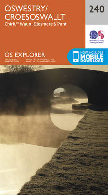
Oswestry, Chirk, Ellesmere and Pant area on a detailed topographic and GPS compatible map No. 240, paper version, from the Ordnance Survey’s 1:25,000 Explorer series.MOBILE DOWNLOADS: this title and all the other OS Explorer maps include a code for downloading after purchase the digital version onto your smartphone or tablet for viewing on the OS
Shrewsbury – Wem, Shawbury & Baschurch OS Explorer Map 241 (paper)

Shrewsbury, Wem, Shawbury and Baschurch area on a detailed topographic and GPS compatible map No. 241, paper version, from the Ordnance Survey’s 1:25,000 Explorer series. MOBILE DOWNLOADS: this title and all the other OS Explorer maps include a code for downloading after purchase the digital version onto your smartphone or tablet for viewing on the
Cambridge – Royston, Duxford & Linton OS Explorer Map 209 (paper)

Cambridge, Royston, Duxford and Linton area on a detailed topographic and GPS compatible map No. 209, paper version, from the Ordnance Survey’s 1:25,000 Explorer series.MOBILE DOWNLOADS: this title and all the other OS Explorer maps include a code for downloading after purchase the digital version onto your smartphone or tablet for viewing on the OS
Ely & Newmarket – Mildenhall & Soham OS Explorer Map 226 (paper)

Ely, Newmarket, Mildenhall and Soham area on a detailed topographic and GPS compatible map No. 226, paper version, from the Ordnance Survey’s 1:25,000 Explorer series. MOBILE DOWNLOADS: this title and all the other OS Explorer maps include a code for downloading after purchase the digital version onto your smartphone or tablet for viewing on the
Newmarket & Haverhill – Barrow, Clare & Kedington OS Explorer Map 210 (paper)

Newmarket, Haverhill, Barrow, Clare and Kedington area on a detailed topographic and GPS compatible map No. 210, paper version, from the Ordnance Survey’s 1:25,000 Explorer series.MOBILE DOWNLOADS: this title and all the other OS Explorer maps include a code for downloading after purchase the digital version onto your smartphone or tablet for viewing on the
Peterborough – March, Whittlesey, Chatteris & Oundle OS Explorer Map 227 (paper)

Peterborough, March, Whittlesey, Chatteris and Oundle area on a detailed topographic and GPS compatible map No. 227, paper version, from the Ordnance Survey’s 1:25,000 Explorer series.MOBILE DOWNLOADS: this title and all the other OS Explorer maps include a code for downloading after purchase the digital version onto your smartphone or tablet for viewing on the
Bury St Edmunds & Stowmarket – Debenham & Elmswell OS Explorer Map 211 (paper)

Bury St Edmunds, Stowmarket, Debenham and Elmswell area on a detailed topographic and GPS compatible map No. 211, paper version, from the Ordnance Survey’s 1:25,000 Explorer series. MOBILE DOWNLOADS: this title and all the other OS Explorer maps include a code for downloading after purchase the digital version onto your smartphone or tablet for viewing
Woodbridge & Saxmundham – Aldeburgh & Framlingham OS Explorer Map 212 (paper)
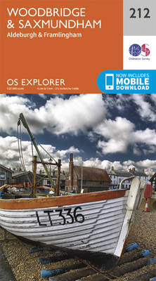
Woodbridge, Saxmundham, Aldeburgh and Framlingham area on a detailed topographic and GPS compatible map No. 212, paper version, from the Ordnance Survey’s 1:25,000 Explorer series. MOBILE DOWNLOADS: this title and all the other OS Explorer maps include a code for downloading after purchase the digital version onto your smartphone or tablet for viewing on the
Aberystwyth & Cwm Rheidol – Devil`s Bridge OS Explorer Map 213 (paper)

Aberystwyth, Cwm Rheidol and Devil`s Bridge area on a detailed topographic and GPS compatible map No. 213, paper version, from the Ordnance Survey’s 1:25,000 Explorer series. MOBILE DOWNLOADS: this title and all the other OS Explorer maps include a code for downloading after purchase the digital version onto your smartphone or tablet for viewing on
Llanidloes & Newtown – Llyn Clywedog OS Explorer Map 214 (paper)

Llanidloes, Newtown and Llyn Clywedog area on a detailed topographic and GPS compatible map No. 214, paper version, from the Ordnance Survey’s 1:25,000 Explorer series. MOBILE DOWNLOADS: this title and all the other OS Explorer maps include a code for downloading after purchase the digital version onto your smartphone or tablet for viewing on the
Newtown & Machynlleth – Llanfair Caereinion OS Explorer Map 215 (paper)
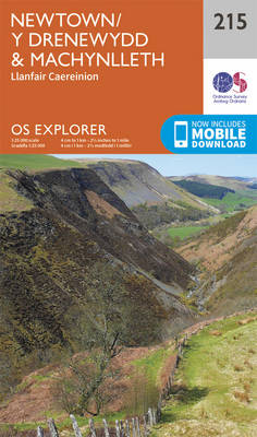
Newtown, Machynlleth and Llanfair Caereinion area on a detailed topographic and GPS compatible map No. 215, paper version, from the Ordnance Survey’s 1:25,000 Explorer series.MOBILE DOWNLOADS: this title and all the other OS Explorer maps include a code for downloading after purchase the digital version onto your smartphone or tablet for viewing on the OS
Welshpool & Montgomery – Bishop`s Castle OS Explorer Map 216 (paper)

Welshpool, Montgomery and Bishop`s Castle area on a detailed topographic and GPS compatible map No. 216, paper version, from the Ordnance Survey’s 1:25,000 Explorer series. MOBILE DOWNLOADS: this title and all the other OS Explorer maps include a code for downloading after purchase the digital version onto your smartphone or tablet for viewing on the
Wyre Forest & Kidderminster – Bridgnorth OS Explorer Map 218 (paper)

Wyre Forest, Kidderminster and Bridgnorth area on a detailed topographic and GPS compatible map No. 218, paper version, from the Ordnance Survey’s 1:25,000 Explorer series. MOBILE DOWNLOADS: this title and all the other OS Explorer maps include a code for downloading after purchase the digital version onto your smartphone or tablet for viewing on the
Wolverhampton & Dudley – Stourbridge & Kidderminster OS Explorer Map 219 (paper)

Wolverhampton, Dudley, Stourbridge and Kidderminster area on a detailed topographic and GPS compatible map No. 219, paper version, from the Ordnance Survey’s 1:25,000 Explorer series. MOBILE DOWNLOADS: this title and all the other OS Explorer maps include a code for downloading after purchase the digital version onto your smartphone or tablet for viewing on the