Category Archives: Maps
Colima
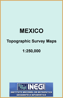
Topographic mapping from Mexico’s national survey agency, Instituto Nacional de Estadรญstica, Geografรญa e Informรกtica. The maps have contours at 20m intervals with relief shading and indicate various types of terrain and vegetation, e.g. dense vegetation, cultivated areas, swamps, sand dunes, salt pans, etc. UTM grid is at 10km intervals, with latitude and longitude shown by
Guanajuato
Topographic mapping from Mexico’s national survey agency, Instituto Nacional de Estadรญstica, Geografรญa e Informรกtica. The maps have contours at 20m intervals with relief shading and indicate various types of terrain and vegetation, e.g. dense vegetation, cultivated areas, swamps, sand dunes, salt pans, etc. UTM grid is at 10km intervals, with latitude and longitude shown by
Maine Raven Maps Physical Wall Map PAPER
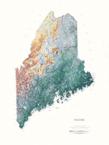
Detailed physical wall map of Maine State at a scale of 1:500,000. The cartography shows relief through a stunning, highly detailed shading, with different elevations varing in colouring, giving an almost 3-dimensional feel to the map. Peak heights are also clearly marked.The map displays land only within the boundaries of the chosen states – there
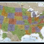
United States Raven Maps Physical Wall Map LAMINATED
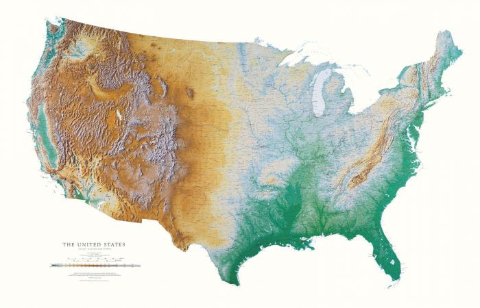
Beautifully detailed laminated 94x148cm (37″x58″) physical wall map of the United States of America at a scale of 1:3,500,000. The cartography shows relief through a highly detailed shading and terrain differentiation is shown through variations in colouring, giving the mapping an almost 3-dimensional feel.The map displays state boundaries; state capitals; major cities; glaciers; mountain ranges;
Oregon State Physical Wall Map
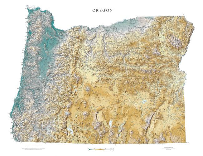
Detailed 110x143cm (43″x56″) physical wall map of Oregon State at a scale of 1:500,000. The cartography shows relief through a stunning, highly detailed shading, with different elevations varing in colouring, giving an almost 3-dimensional feel to the map. Peak heights are also clearly marked.The map displays land only within the boundaries of the chosen states
Aguascalientes State
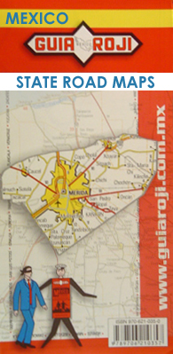
One of the titles in a series of road maps of the administrative states of Mexico, highlighting places of interest. The maps show four different grades of roads, with intermediate driving distances on main routes, railways, local airports, ferry connections and administrative boundaries. Topographic information is limited to names of main mountain ranges, spot heights
Ohio State Physical Wall Map
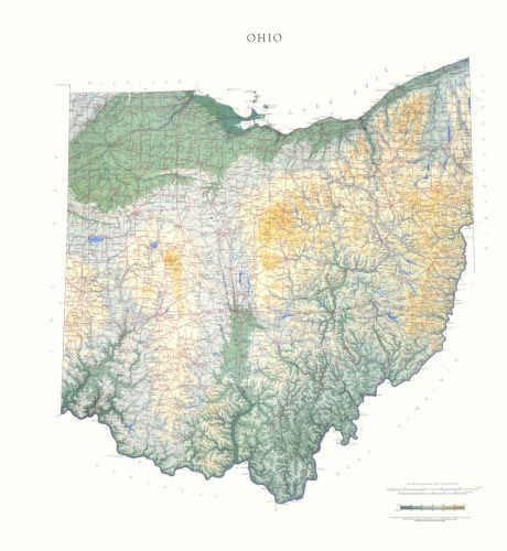
Detailed physical wall map of Ohio State at a scale of 1:500,000. The cartography shows relief through a stunning, highly detailed shading, with different elevations varing in colouring, giving an almost 3-dimensional feel to the map. Peak heights are also clearly marked.The map displays land only within the boundaries of the chosen states – there
New York Raven Maps Physical Wall Map PAPER
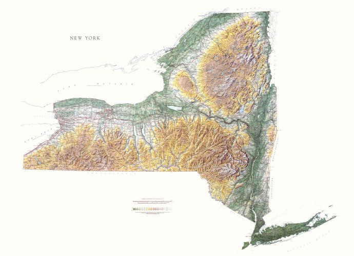
Detailed physical wall map of New York State at a scale of 1:500,000. The cartography shows relief through a stunning, highly detailed shading, with different elevations varing in colouring, giving an almost 3-dimensional feel to the map. Peak heights are also clearly marked.The map displays land only within the boundaries of the chosen states –
Florida State Physical Wall Map
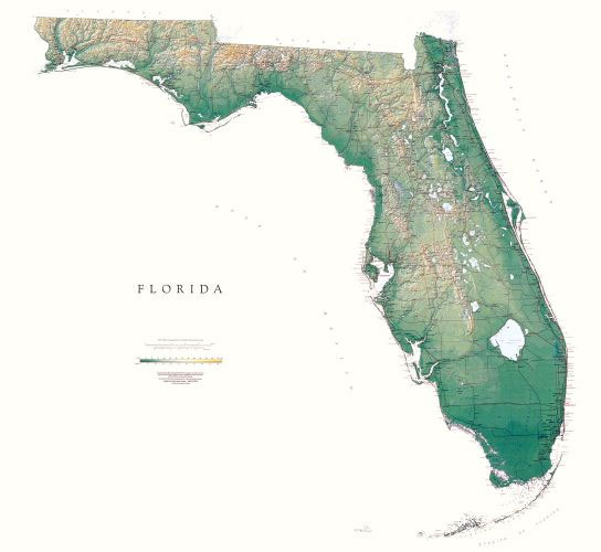
Detailed physical wall map of Florida State at a scale of 1:700,000. The cartography shows relief through a stunning, highly detailed shading, with different elevations varing in colouring, giving an almost 3-dimensional feel to the map. Peak heights are also clearly marked.The map displays land only within the boundaries of the chosen states – there
Alaska State Physical Wall Map
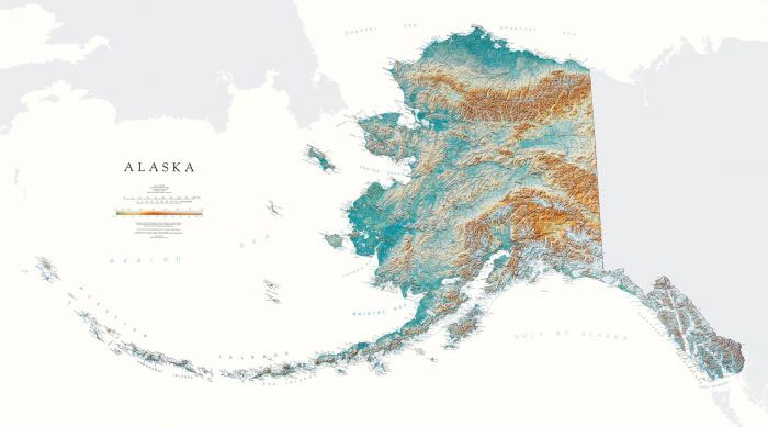
Detailed physical wall map of Alaska State at a scale of 1:2,500,000. The cartography shows relief through a stunning, highly detailed shading, with different elevations varing in colouring, giving an almost 3-dimensional feel to the map. Peak heights are also clearly marked.The map displays land only within the boundaries of the chosen states – there
Maximum Climbing: Mental Training for Peak Performance and Optimal Experience

Eric Horst brings unprecedented clarity to the many cognitive and neurophysical aspects of climbing and dovetails this information into a complete program, setting forth three stages of mental training that correspond to beginner, intermediate, and elite levels of experience and commitment-the ideal template to build upon to personalize one`s goals through years of climbing to
Arizona Raven Maps Physical Wall Map PAPER
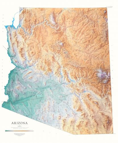
Detailed physical wall map of Arizona State at a scale of 1:550,000. The cartography shows relief through a stunning, highly detailed shading, with different elevations varing in colouring, giving an almost 3-dimensional feel to the map. Peak heights are also clearly marked.The map displays land only within the boundaries of the chosen states – there
How to Climb 5.12
The essential manual for intermediate climbers who want to make the jump to advanced climbing ability-with new color photos In the sport of rock climbing, 5.12 is a magical grade of difficulty-the rating that separates intermediate climbers from the sport`s elite. Many intermediate climbers mistakenly believe that climbs of 5.12 difficulty are simply beyond their
California State Physical Wall Map
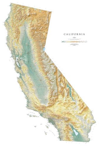
Detailed physical wall map of California State at a scale of 1:750,000. The cartography shows relief through a stunning, highly detailed shading, with different elevations varing in colouring, giving an almost 3-dimensional feel to the map. Peak heights are also clearly marked.The map displays land only within the boundaries of the chosen states – there
World Etymological Map (Atlas of True Names)
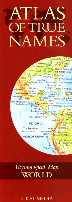
The Atlas of True Names reveals the etymological roots, or original meanings, of the familiar terms on today`s map of the World. For instance, where you would normally expect to see the Sahara indicated, the ‘Atlas’ gives you “Sea of Sand”, Arab. es-sahra “desert, sea of sand”. The `True Names` of 1500 cities, countries, rivers,
Europe Etymological Map (Atlas of True Names)
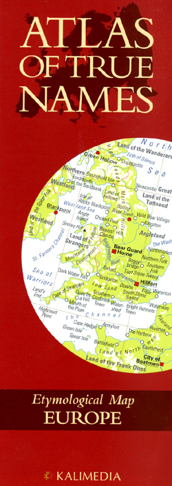
The Atlas of True Names reveals the etymological roots, or original meanings, of the familiar terms on today`s map of Europe. For instance, where you would normally expect to see London indicated, the ‘Atlas’ gives you “Hillfort. The `True Names` of 1500 cities, countries, rivers, oceans and mountain ranges are displayed on this fascinating map,
Just Ride

“Just Ride” is the single best book for any newly passionate or well-established bike rider. It simplifies bike riding to the essentials, plus plenty of fun, smart stuff. As the author of this manifesto on the best way to ride, Grant Petersen takes no prisoners. His wise words will muffle the noisy show-offs who tout
Charles Dickens – The Complete Novels In One Sitting

2012 marks the 200th anniversary of the birth of Charles Dickens, and what better way to celebrate than this pocket-size guide! Meet the cast of from all of Dickens` classic novels and devour the plots in one sitting. This pocket-size tome is both the perfect introduction to the world of Dickens, and great for brushing
An: to Eat: Recipes and Stories from a Vietnamese Family Kitchen

In Vietnamese, “AN” means “TO EAT,” a happy coincidence, since the An family has built an award-winning restaurant empire– including the renowned celebrity favorite Crustacean Beverly Hills–that has been toasted by leading food press, including Bon Appetit, Gourmet, InStyle and the Food Network. Helene An, executive chef and matriarch of the House of An, is