Category Archives: Maps
North Dakota Raven Maps Physical Wall Map PAPER
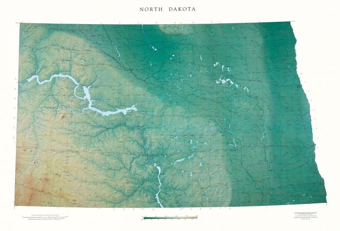
Detailed physical wall map of North Dakota State at a scale of 1:500,000. The cartography shows relief through a stunning, highly detailed shading, with different elevations varing in colouring, giving an almost 3-dimensional feel to the map. Peak heights are also clearly marked.The map displays land only within the boundaries of the chosen states –
South Dakota Raven Maps Physical Wall Map PAPER
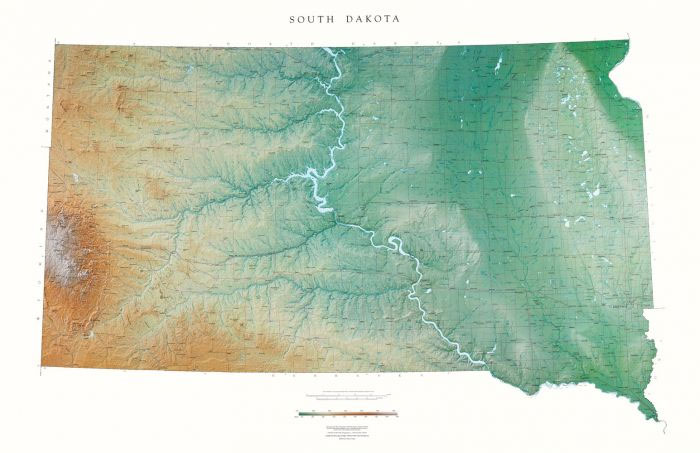
Detailed physical wall map of South Dakota State at a scale of 1:500,000. The cartography shows relief through a stunning, highly detailed shading, with different elevations varing in colouring, giving an almost 3-dimensional feel to the map. Peak heights are also clearly marked.The map displays land only within the boundaries of the chosen states –
Alabama Raven Maps Physical Wall Map PAPER
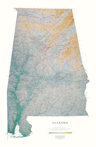
Detailed physical wall map of Alabama State at a scale of 1:500,000. The cartography shows relief through a stunning, highly detailed shading, with different elevations varing in colouring, giving an almost 3-dimensional feel to the map. Peak heights are also clearly marked.The map displays land only within the boundaries of the chosen states – there
Iowa Raven Maps Physical Wall Map PAPER
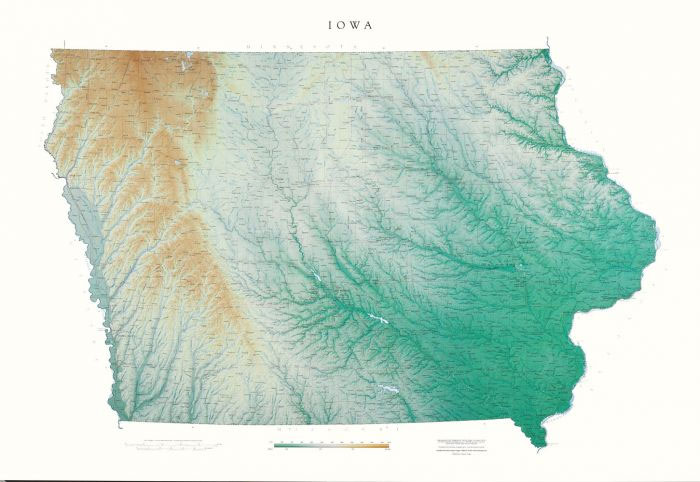
Detailed physical wall map of Iowa State at a scale of 1:500,000. The cartography shows relief through a stunning, highly detailed shading, with different elevations varing in colouring, giving an almost 3-dimensional feel to the map. Peak heights are also clearly marked.The map displays land only within the boundaries of the chosen states – there
Virginia, Maryland, Delaware & DC Raven Maps Physical Wall Map PAPER
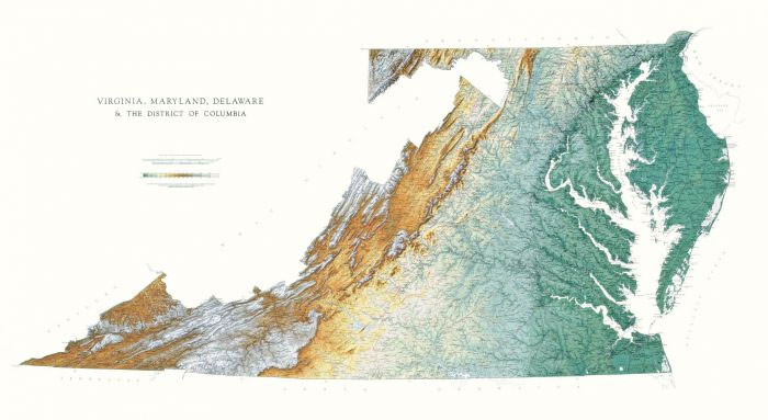
Detailed physical wall map of Virginia, Maryland, Delaware & DC at a scale of 1:500,000. The cartography shows relief through a stunning, highly detailed shading, with different elevations varing in colouring, giving an almost 3-dimensional feel to the map. Peak heights are also clearly marked.The map displays land only within the boundaries of the chosen
Mississippi Raven Maps Physical Wall Map PAPER
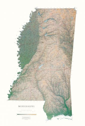
Detailed physical wall map of Mississippi State at a scale of 1:500,000. The cartography shows relief through a stunning, highly detailed shading, with different elevations varing in colouring, giving an almost 3-dimensional feel to the map. Peak heights are also clearly marked.The map displays land only within the boundaries of the chosen states – there
Vermont & New Hampshire Raven Maps Physical Wall Map PAPER
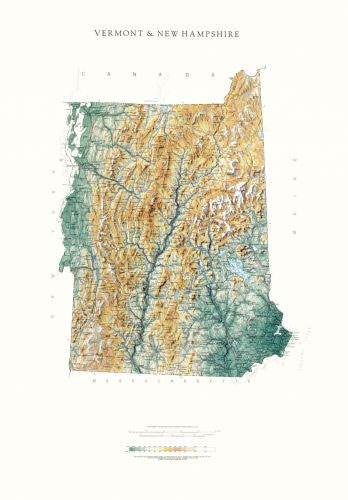
Detailed physical wall map of Vermont & New Hampshire States at a scale of 1:500,000. The cartography shows relief through a stunning, highly detailed shading, with different elevations varing in colouring, giving an almost 3-dimensional feel to the map. Peak heights are also clearly marked.The map displays land only within the boundaries of the chosen
Nebraska Raven Maps Physical Wall Map PAPER
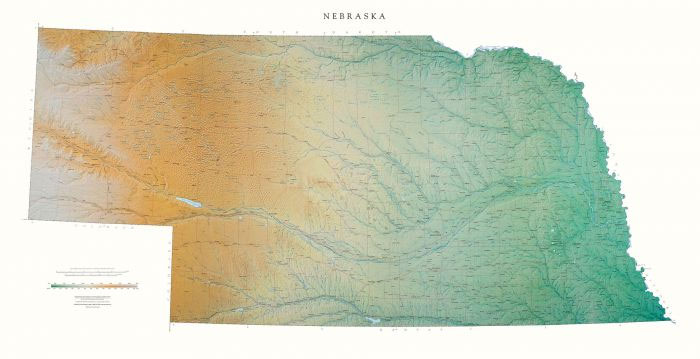
Detailed physical wall map of Nebraska State at a scale of 1:500,000. The cartography shows relief through a stunning, highly detailed shading, with different elevations varing in colouring, giving an almost 3-dimensional feel to the map. Peak heights are also clearly marked.The map displays land only within the boundaries of the chosen states – there
Washington State Physical Wall Map
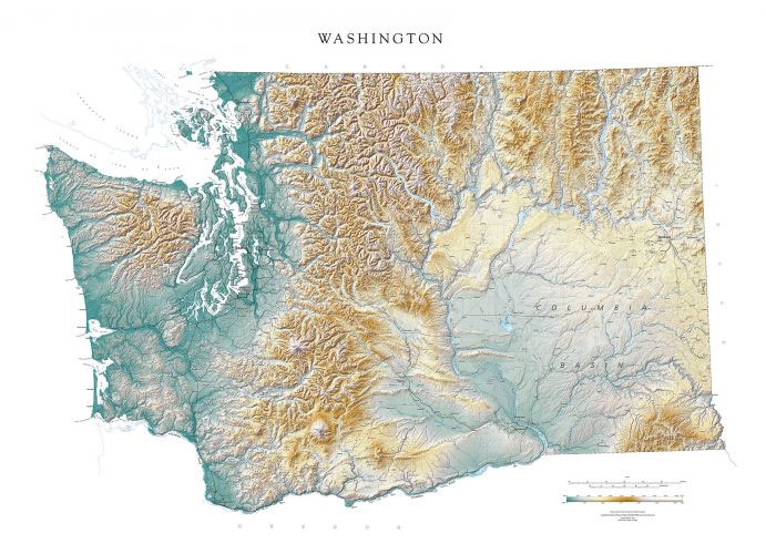
Detailed physical wall map of Washington State at a scale of 1:500,000. The cartography shows relief through a stunning, highly detailed shading, with different elevations varing in colouring, giving an almost 3-dimensional feel to the map. Peak heights are also clearly marked.The map displays land only within the boundaries of the chosen states – there
Highway 395 – Carson City NV to Lone Pine CA Benchmark Road Map
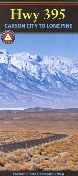
Highway 395’s most scenic section, from the capital of Nevada, Carson City, to Lone Pine in California along the eastern edge of the Sierra Nevada on a detailed, double-sided map at 1:213,220 (1 inch to 4 miles) from Benchmark Maps.The map highlights the route and shows the surrounding road network which provides access both to
Wisconsin Raven Maps Physical Wall Map PAPER
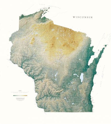
Detailed physical wall map of Wisconsin State at a scale of 1:500,000. The cartography shows relief through a stunning, highly detailed shading, with different elevations varing in colouring, giving an almost 3-dimensional feel to the map. Peak heights are also clearly marked.The map displays land only within the boundaries of the chosen states – there
Yosemite National Park Area
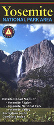
Yosemite National Park and the surrounding region from Benchmark Maps on a three-in-one indexed map providing an increasing level of detail, plus information on campgrounds and other accommodation, attractions, etc. On one side is a general road map of the region at 1:300,000 approx., centered on the Yosemite National Park, with relief shading and plenty
West Virginia Raven Maps Physical Wall Map PAPER
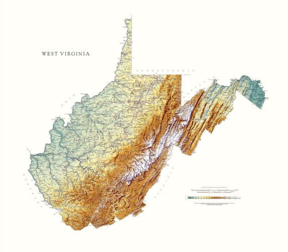
Detailed physical wall map of West Virginia State at a scale of 1:500,000. The cartography shows relief through a stunning, highly detailed shading, with different elevations varing in colouring, giving an almost 3-dimensional feel to the map. Peak heights are also clearly marked.The map displays land only within the boundaries of the chosen states –
Wyoming Raven Maps Physical Wall Map PAPER
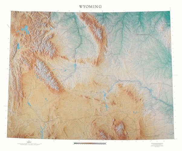
Detailed physical wall map of Wyoming State at a scale of 1:500,000. The cartography shows relief through a stunning, highly detailed shading, with different elevations varing in colouring, giving an almost 3-dimensional feel to the map. Peak heights are also clearly marked.The map displays land only within the boundaries of the chosen states – there
United States Raven Maps Physical Wall Map PAPER
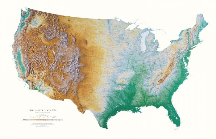
Beautifully detailed 94x148cm (37″x58″) physical wall map of the United States of America at a scale of 1:3,500,000. The cartography shows relief through a highly detailed shading and terrain differentiation is shown through variations in colouring, giving the mapping an almost 3-dimensional feel.The map displays state boundaries; state capitals; major cities; glaciers; mountain ranges; rivers
Montana State Physical Wall Map
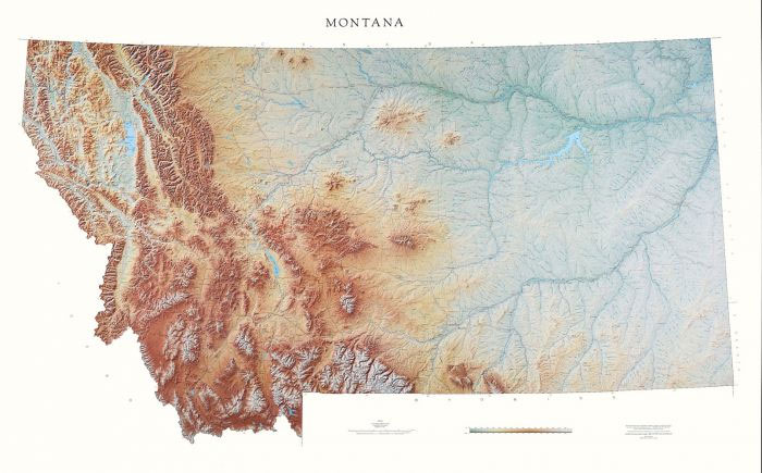
Detailed physical wall map of Montana State at a scale of 1:600,000. The cartography shows relief through a stunning, highly detailed shading, with different elevations varing in colouring, giving an almost 3-dimensional feel to the map. Peak heights are also clearly marked.The map displays land only within the boundaries of the chosen states – there
North Carolina State Physical Wall Map
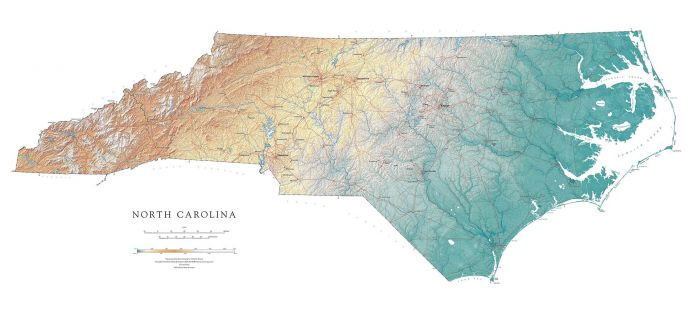
Detailed physical wall map of North Carolina State at a scale of 1:500,000. The cartography shows relief through a stunning, highly detailed shading, with different elevations varing in colouring, giving an almost 3-dimensional feel to the map. Peak heights are also clearly marked.The map displays land only within the boundaries of the chosen states –
New Mexico Raven Maps Physical Wall Map PAPER
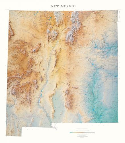
Detailed physical wall map of New Mexico State at a scale of 1:550,000. The cartography shows relief through a stunning, highly detailed shading, with different elevations varing in colouring, giving an almost 3-dimensional feel to the map. Peak heights are also clearly marked.The map displays land only within the boundaries of the chosen states –
Nevada State Physical Wall Map
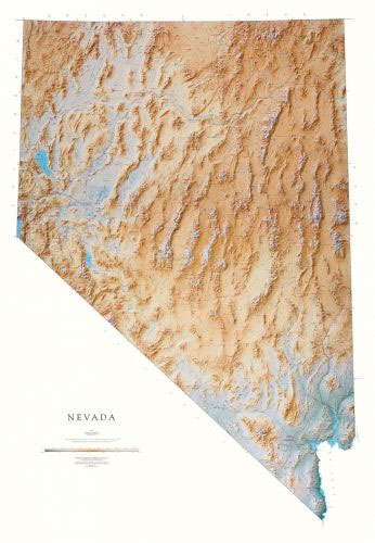
Detailed physical wall map of Nevada State at a scale of 1:550,000. The cartography shows relief through a stunning, highly detailed shading, with different elevations varing in colouring, giving an almost 3-dimensional feel to the map. Peak heights are also clearly marked.The map displays land only within the boundaries of the chosen states – there
Pennsylvania and New Jersey Raven Maps Physical Wall Map PAPER
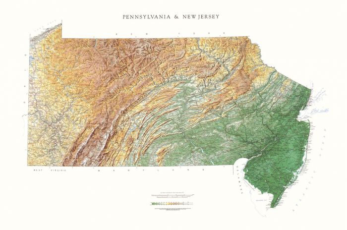
Detailed physical wall map of Pennsylvania & New Jersey States at a scale of 1:500,000. The cartography shows relief through a stunning, highly detailed shading, with different elevations varing in colouring, giving an almost 3-dimensional feel to the map. Peak heights are also clearly marked.The map displays land only within the boundaries of the chosen