Category Archives: Maps
Gouvy – Thommen
Topographical survey of Belgium at 1:20,000 from Nationaal Geografisch Instituut / Institut Gรฉographique National, the country’s national survey organization. Each 20K map covers one quarter of the corresponding 1:50,000 map (with adjustments in the border and coastal areas). The maps provide all the information expected of topographic mapping at this scale and additionally have an
Manderfeld
Topographical survey of Belgium at 1:20,000 from Nationaal Geografisch Instituut / Institut Gรฉographique National, the country’s national survey organization. Each 20K map covers one quarter of the corresponding 1:50,000 map (with adjustments in the border and coastal areas). The maps provide all the information expected of topographic mapping at this scale and additionally have an
Rochefort – Nassogne
Topographical survey of Belgium at 1:20,000 from Nationaal Geografisch Instituut / Institut Gรฉographique National, the country’s national survey organization. Each 20K map covers one quarter of the corresponding 1:50,000 map (with adjustments in the border and coastal areas). The maps provide all the information expected of topographic mapping at this scale and additionally have an
Wellin – Daverdisse
Topographical survey of Belgium at 1:20,000 from Nationaal Geografisch Instituut / Institut Gรฉographique National, the country’s national survey organization. Each 20K map covers one quarter of the corresponding 1:50,000 map (with adjustments in the border and coastal areas). The maps provide all the information expected of topographic mapping at this scale and additionally have an
Quievrain – Boussu
Topographical survey of Belgium at 1:20,000 from Nationaal Geografisch Instituut / Institut Gรฉographique National, the country’s national survey organization. Each 20K map covers one quarter of the corresponding 1:50,000 map (with adjustments in the border and coastal areas). The maps provide all the information expected of topographic mapping at this scale and additionally have an
Ouren
Topographical survey of Belgium at 1:20,000 from Nationaal Geografisch Instituut / Institut Gรฉographique National, the country’s national survey organization. Each 20K map covers one quarter of the corresponding 1:50,000 map (with adjustments in the border and coastal areas). The maps provide all the information expected of topographic mapping at this scale and additionally have an
Antoing – Leuze-en-Hainaut 20K NGI Belgium Survey Map No. 37/7-8
Topographical survey of Belgium at 1:20,000 from Nationaal Geografisch Instituut / Institut Gรฉographique National, the country’s national survey organization. Each 20K map covers one quarter of the corresponding 1:50,000 map (with adjustments in the border and coastal areas). The maps provide all the information expected of topographic mapping at this scale and additionally have an
Rebeque – Ittre 20K NGI Belgium Survey Map No. 39/1-2
Topographical survey of Belgium at 1:20,000 from Nationaal Geografisch Instituut / Institut Gรฉographique National, the country’s national survey organization. Each 20K map covers one quarter of the corresponding 1:50,000 map (with adjustments in the border and coastal areas). The maps provide all the information expected of topographic mapping at this scale and additionally have an
Waterloo – Lasne: Battle of Waterloo Area 20K NGI Belgium Survey Map No. 39/3-4
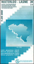
Waterloo – Lanse, map No. 39/3-4 in the topographic survey of Belgium at 1:20,000 covering the main area of the Battle of Waterloo on 18th June 1815 including the Mont St-Jean escarpment, the Lion’s Mound (Lion’s Hillock) and the museum. Although not specifically designed to highlight locations connected with the Battle of Waterloo, the map
Braine-le-Comte 20K NGI Belgium Survey Map No. 39/5-6
Topographical survey of Belgium at 1:20,000 from Nationaal Geografisch Instituut / Institut Gรฉographique National, the country’s national survey organization. Each 20K map covers one quarter of the corresponding 1:50,000 map (with adjustments in the border and coastal areas). The maps provide all the information expected of topographic mapping at this scale and additionally have an
Nivelles – Genappe: Battle of Waterloo Area 20K NGI Belgium Survey Map No. 39/7-8
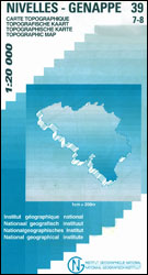
Nivelles – Genappe, map No. 39/7-8 in the topographic survey of Belgium at 1:20,000 covering an area east of the town of Nivelles including Les Quatre Bras, the site of French victory on 16th June 1815, two days before the Battle of Waterloo.Although not specifically designed to highlight locations connected with the Battle of Waterloo,
Ans – Liรจge 20K NGI Belgium Survey Map No. 42/1-2
Topographical survey of Belgium at 1:20,000 from Nationaal Geografisch Instituut / Institut Gรฉographique National, the country’s national survey organization. Each 20K map covers one quarter of the corresponding 1:50,000 map (with adjustments in the border and coastal areas). The maps provide all the information expected of topographic mapping at this scale and additionally have an
Dalhem – Herve
Topographical survey of Belgium at 1:20,000 from Nationaal Geografisch Instituut / Institut Gรฉographique National, the country’s national survey organization. Each 20K map covers one quarter of the corresponding 1:50,000 map (with adjustments in the border and coastal areas). The maps provide all the information expected of topographic mapping at this scale and additionally have an
Seraing – Chaudfontaine
Topographical survey of Belgium at 1:20,000 from Nationaal Geografisch Instituut / Institut Gรฉographique National, the country’s national survey organization. Each 20K map covers one quarter of the corresponding 1:50,000 map (with adjustments in the border and coastal areas). The maps provide all the information expected of topographic mapping at this scale and additionally have an
Fleron – Verviers
Topographical survey of Belgium at 1:20,000 from Nationaal Geografisch Instituut / Institut Gรฉographique National, the country’s national survey organization. Each 20K map covers one quarter of the corresponding 1:50,000 map (with adjustments in the border and coastal areas). The maps provide all the information expected of topographic mapping at this scale and additionally have an
Welkenraedt – Kelmis (La Calamine)
Topographical survey of Belgium at 1:20,000 from Nationaal Geografisch Instituut / Institut Gรฉographique National, the country’s national survey organization. Each 20K map covers one quarter of the corresponding 1:50,000 map (with adjustments in the border and coastal areas). The maps provide all the information expected of topographic mapping at this scale and additionally have an
Petergensfeld – Lammersdorf
Topographical survey of Belgium at 1:20,000 from Nationaal Geografisch Instituut / Institut Gรฉographique National, the country’s national survey organization. Each 20K map covers one quarter of the corresponding 1:50,000 map (with adjustments in the border and coastal areas). The maps provide all the information expected of topographic mapping at this scale and additionally have an
Lennik – Sint-Pieters-Leeuw
Topographical survey of Belgium at 1:20,000 from Nationaal Geografisch Instituut / Institut Gรฉographique National, the country’s national survey organization. Each 20K map covers one quarter of the corresponding 1:50,000 map (with adjustments in the border and coastal areas). The maps provide all the information expected of topographic mapping at this scale and additionally have an
Limbourg – Eupen 20K NGI Belgium Survey Map No. 43/5-6
Topographical survey of Belgium at 1:20,000 from Nationaal Geografisch Instituut / Institut Gรฉographique National, the country’s national survey organization. Each 20K map covers one quarter of the corresponding 1:50,000 map (with adjustments in the border and coastal areas). The maps provide all the information expected of topographic mapping at this scale and additionally have an
Ukkel – Hoeilaart
Topographical survey of Belgium at 1:20,000 from Nationaal Geografisch Instituut / Institut Gรฉographique National, the country’s national survey organization. Each 20K map covers one quarter of the corresponding 1:50,000 map (with adjustments in the border and coastal areas). The maps provide all the information expected of topographic mapping at this scale and additionally have an