Category Archives: Maps
Bude & Clovelly 1919 – 190

Map No. 190, Bude and Clovelly 1919, in the Cassini Historical Series of old Ordnance Survey mapping of England and Wales at 1:50,000 in a format designed to offer a convenient comparison with the present day coverage from the OS, and most locations in three different editions. Old historical maps have been combined so that
Okehampton and North Dartmoor 1919
Map No. 191, Okehampton and North Dartmoor 1919, in the Cassini Historical Series of old Ordnance Survey mapping of England and Wales at 1:50,000 in a format designed to offer a convenient comparison with the present day coverage from the OS, and most locations in three different editions. Old historical maps have been combined so
Boston and Spalding 1922
Map No. 131, Boston and Spalding 1922, in the Cassini Historical Series of old Ordnance Survey mapping of England and Wales at 1:50,000 in a format designed to offer a convenient comparison with the present day coverage from the OS, and most locations in three different editions. Old historical maps have been combined so that
Brighton & Lewes 1813-1819
Map No. 198, Brighton and Lewes 1813-1819, in the Cassini Historical Series of old Ordnance Survey mapping of England and Wales at 1:50,000 in a format designed to offer a convenient comparison with the present day coverage from the OS, and most locations in three different editions. Old historical maps have been combined so that
Thetford & Diss 1920-1922
Map No. 144, Thetford and Diss 1920-1922, in the Cassini Historical Series of old Ordnance Survey mapping of England and Wales at 1:50,000 in a format designed to offer a convenient comparison with the present day coverage from the OS, and most locations in three different editions. Old historical maps have been combined so that
Bournemouth and Purbeck 1811
Map No. 195, Bournemouth and Purbeck 1811, in the Cassini Historical Series of old Ordnance Survey mapping of England and Wales at 1:50,000 in a format designed to offer a convenient comparison with the present day coverage from the OS, and most locations in three different editions. Old historical maps have been combined so that
Stoke-on-Trent and Macclesfield 1921-1923
Map No. 118, Stoke-on-Trent and Macclesfield 1921-1923, in the Cassini Historical Series of old Ordnance Survey mapping of England and Wales at 1:50,000 in a format designed to offer a convenient comparison with the present day coverage from the OS, and most locations in three different editions. Old historical maps have been combined so that
Ely, Haddenham and Littleport Past and Present
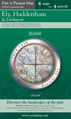
Ely, Haddenham and Littleport in the Cassini Past and Present map series which covers town and cities of England and Wales and offers a unique way of tracing their history and expansion by showing four different periods of their development using Ordnance Survey mapping from the mid-19th century, the late 19th century, the 1920s and
Buxton and Matlock 1921-1923
Map No. 119, Buxton and Matlock 1921-1923, in the Cassini Historical Series of old Ordnance Survey mapping of England and Wales at 1:50,000 in a format designed to offer a convenient comparison with the present day coverage from the OS, and most locations in three different editions. Old historical maps have been combined so that
Richmond and Ealing Past and Present
London boroughs of Richmond and Ealing in the Cassini Past and Present map series which covers town and cities of England and Wales and offers a unique way of tracing their history and expansion by showing four different periods of their development using Ordnance Survey mapping from the mid-19th century, the late 19th century, the
Ludlow / Llwydlo & Church Stretton 1920-1921
Map No. 137, Church Stretton and Ludlow / Llwydlo 1920-1921, in the Cassini Historical Series of old Ordnance Survey mapping of England and Wales at 1:50,000 in a format designed to offer a convenient comparison with the present day coverage from the OS, and most locations in three different editions. Old historical maps have been
Aylesbury and Leighton Buzzard 1919-1920
Map No. 165, Aylesbury and Leighton Buzzard 1919-1920, in the Cassini Historical Series of old Ordnance Survey mapping of England and Wales at 1:50,000 in a format designed to offer a convenient comparison with the present day coverage from the OS, and most locations in three different editions. Old historical maps have been combined so
Chelmsford 1919-1922
Map No. 167, Chelmsford 1919-1922, in the Cassini Historical Series of old Ordnance Survey mapping of England and Wales at 1:50,000 in a format designed to offer a convenient comparison with the present day coverage from the OS, and most locations in three different editions. Old historical maps have been combined so that the sheet
Ashford and Romney Marsh 1920-1921
Map No. 189, Ashford and Romney Marsh 1920-1921, in the Cassini Historical Series of old Ordnance Survey mapping of England and Wales at 1:50,000 in a format designed to offer a convenient comparison with the present day coverage from the OS, and most locations in three different editions. Old historical maps have been combined so
Swindon and Devizes 1919
Map No. 173, Swindon and Devizes 1919, in the Cassini Historical Series of old Ordnance Survey mapping of England and Wales at 1:50,000 in a format designed to offer a convenient comparison with the present day coverage from the OS, and most locations in three different editions. Old historical maps have been combined so that
Newbury and Wantage 1919
Map No. 174, Newbury and Wantage 1919, in the Cassini Historical Series of old Ordnance Survey mapping of England and Wales at 1:50,000 in a format designed to offer a convenient comparison with the present day coverage from the OS, and most locations in three different editions. Old historical maps have been combined so that
Newquay and Bodmin 1919
Map No. 200, Newquay and Bodmin 1919, in the Cassini Historical Series of old Ordnance Survey mapping of England and Wales at 1:50,000 in a format designed to offer a convenient comparison with the present day coverage from the OS, and most locations in three different editions. Old historical maps have been combined so that
Truro and Falmouth 1919
Map No. 204, Truro and Falmouth 1919, in the Cassini Historical Series of old Ordnance Survey mapping of England and Wales at 1:50,000 in a format designed to offer a convenient comparison with the present day coverage from the OS, and most locations in three different editions. Old historical maps have been combined so that
Minehead and Brendon Hills 1919
Map No. 181, Minehead and Brendon Hills 1919, in the Cassini Historical Series of old Ordnance Survey mapping of England and Wales at 1:50,000 in a format designed to offer a convenient comparison with the present day coverage from the OS, and most locations in three different editions. Old historical maps have been combined so
Weston-super-Mare 1919-1922
Map No. 182, Weston-super-Mare 1919-1922, in the Cassini Historical Series of old Ordnance Survey mapping of England and Wales at 1:50,000 in a format designed to offer a convenient comparison with the present day coverage from the OS, and most locations in three different editions. Old historical maps have been combined so that the sheet