Category Archives: Maps
Stanford`s Library Map of South America (1864) – A1 Wall Map, Canvas

The Stanford’s Map of South America is from a fascinating series of reproductions from our Edward Stanford Cartographic Collection archive. This reproduction of a map published in 1879 by the founder of our company, Edward Stanford. It was constructed in 1864 by Alexander Keith Johnston who was a geographer in Edinburgh for the Queen. The
Stanford`s Library Map of South America (1864) – Original Size Wall Map, Paper

The Stanford’s Map of South America is from a fascinating series of reproductions from our Edward Stanford Cartographic Collection archive. This reproduction of a map published in 1879 by the founder of our company, Edward Stanford. It was constructed in 1864 by Alexander Keith Johnston who was a geographer in Edinburgh for the Queen. The
Stanford`s Library Map of South America (1864) – Original Size Wall Map, Canvas

The Stanford’s Map of South America is from a fascinating series of reproductions from our Edward Stanford Cartographic Collection archive. This reproduction of a map published in 1879 by the founder of our company, Edward Stanford. It was constructed in 1864 by Alexander Keith Johnston who was a geographer in Edinburgh for the Queen. The
Stanford`s Folio Europe Map, by J. Arrowsmith (1884) – A4 Wall Map, Paper
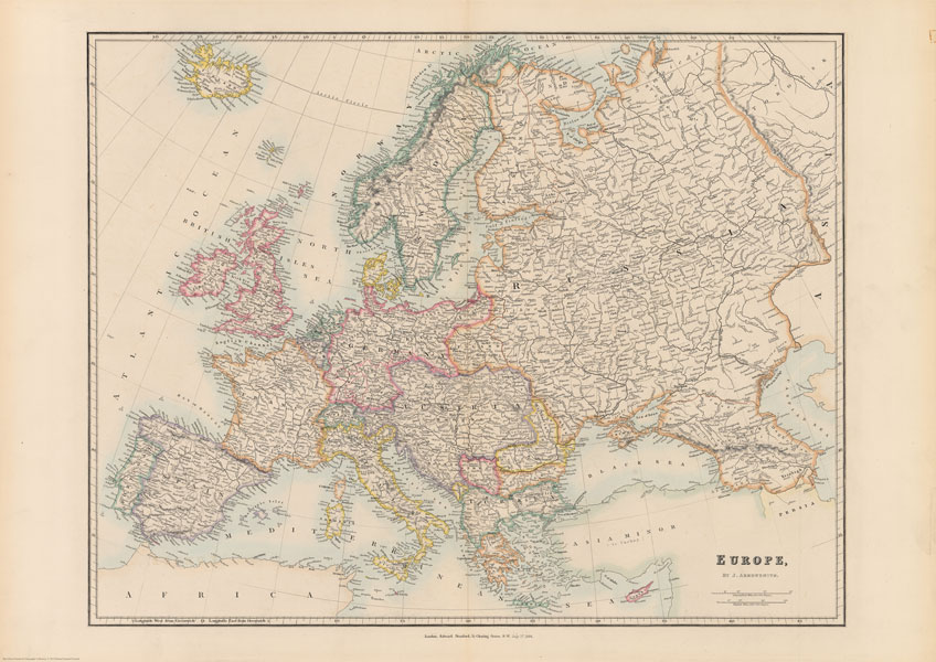
The Stanford’s Europe Map is from a fascinating series of reproductions from our Edward Stanford Cartographic Collection archive.This map was made by the famous cartographer John Arrowsmith and published by Stanfords in 1884.The map presents the continent at the height of its great empires: imperial Russia with Finland and much of Poland, united Germany including
Stanford`s Folio Europe Map, by J. Arrowsmith (1884) – A4 Wall Map, Canvas

The Stanford’s Europe Map is from a fascinating series of reproductions from our Edward Stanford Cartographic Collection archive.This map was made by the famous cartographer John Arrowsmith and published by Stanfords in 1884.The map presents the continent at the height of its great empires: imperial Russia with Finland and much of Poland, united Germany including
Stanford`s Folio Europe Map, by J. Arrowsmith (1884) – A3 Wall Map, Paper

The Stanford’s Europe Map is from a fascinating series of reproductions from our Edward Stanford Cartographic Collection archive.This map was made by the famous cartographer John Arrowsmith and published by Stanfords in 1884.The map presents the continent at the height of its great empires: imperial Russia with Finland and much of Poland, united Germany including
Stanford`s Folio Europe Map, by J. Arrowsmith (1884) – A3 Wall Map, Canvas

The Stanford’s Europe Map is from a fascinating series of reproductions from our Edward Stanford Cartographic Collection archive.This map was made by the famous cartographer John Arrowsmith and published by Stanfords in 1884.The map presents the continent at the height of its great empires: imperial Russia with Finland and much of Poland, united Germany including
Stanford`s Folio Europe Map, by J. Arrowsmith (1884) – A2 Wall Map, Paper

The Stanford’s Europe Map is from a fascinating series of reproductions from our Edward Stanford Cartographic Collection archive.This map was made by the famous cartographer John Arrowsmith and published by Stanfords in 1884.The map presents the continent at the height of its great empires: imperial Russia with Finland and much of Poland, united Germany including
Stanford`s Pacific-centred World Map (1884) – Original Size Wall Map, Paper
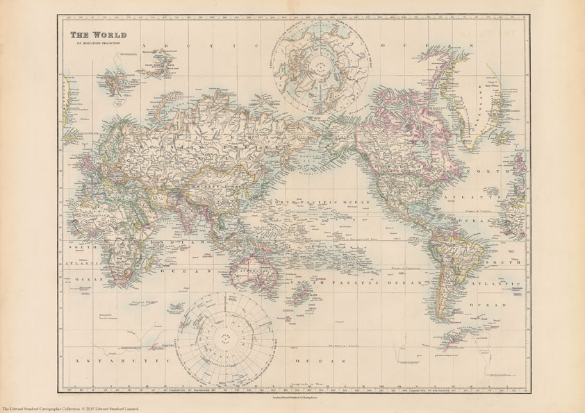
The Stanford’s Map of The Eastern Hemisphere is from a fascinating series of reproductions from our Edward Stanford Cartographic Collection archive.The original map from 1877 was drawn by Stanford’s Geographical Establishment and ‘published under the direction of the Committee of General Literature and Education Appointed by The Society for Promoting Christian Knowledge and of the
Stanford`s Folio Europe Map, by J. Arrowsmith (1884) – A2 Wall Map, Canvas

The Stanford’s Europe Map is from a fascinating series of reproductions from our Edward Stanford Cartographic Collection archive.This map was made by the famous cartographer John Arrowsmith and published by Stanfords in 1884.The map presents the continent at the height of its great empires: imperial Russia with Finland and much of Poland, united Germany including
Stanford`s Pacific-centred World Map (1884) – Original Size Wall Map, Canvas

The Stanford’s Map of The Eastern Hemisphere is from a fascinating series of reproductions from our Edward Stanford Cartographic Collection archive.The original map from 1877 was drawn by Stanford’s Geographical Establishment and ‘published under the direction of the Committee of General Literature and Education Appointed by The Society for Promoting Christian Knowledge and of the
Stanford`s Folio Europe Map, by J. Arrowsmith (1884) – A1 Wall Map, Paper

The Stanford’s Europe Map is from a fascinating series of reproductions from our Edward Stanford Cartographic Collection archive.This map was made by the famous cartographer John Arrowsmith and published by Stanfords in 1884.The map presents the continent at the height of its great empires: imperial Russia with Finland and much of Poland, united Germany including
Stanford`s Library Map of South America (1864) – A4 Wall Map, Canvas

The Stanford’s Map of South America is from a fascinating series of reproductions from our Edward Stanford Cartographic Collection archive. This reproduction of a map published in 1879 by the founder of our company, Edward Stanford. It was constructed in 1864 by Alexander Keith Johnston who was a geographer in Edinburgh for the Queen. The
Stanford`s Folio Europe Map, by J. Arrowsmith (1884) – A1 Wall Map, Canvas

The Stanford’s Europe Map is from a fascinating series of reproductions from our Edward Stanford Cartographic Collection archive.This map was made by the famous cartographer John Arrowsmith and published by Stanfords in 1884.The map presents the continent at the height of its great empires: imperial Russia with Finland and much of Poland, united Germany including
Stanford`s Library Map of South America (1864) – A3 Wall Map, Paper

The Stanford’s Map of South America is from a fascinating series of reproductions from our Edward Stanford Cartographic Collection archive. This reproduction of a map published in 1879 by the founder of our company, Edward Stanford. It was constructed in 1864 by Alexander Keith Johnston who was a geographer in Edinburgh for the Queen. The
Stanford`s Folio British Isles Map (1884) – A4 Wall Map, Paper
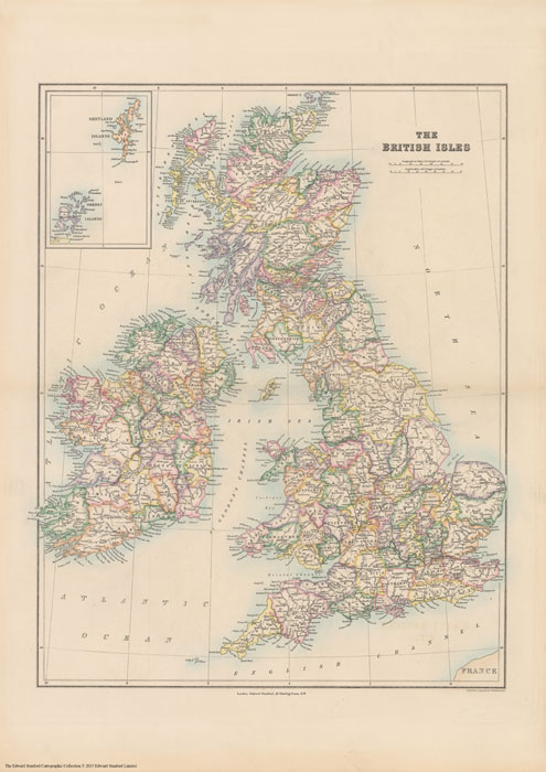
The Stanford’s British Isles Map is from a fascinating series of reproductions from our Edward Stanford Cartographic Collection archive.Published in 1884, this map shows the British Isles with their old historic counties. Bright colours highlight the boundaries of the old counties as they were. The pale background makes all the place names easy to read.
Stanford`s Library Map of South America (1864) – A3 Wall Map, Canvas

The Stanford’s Map of South America is from a fascinating series of reproductions from our Edward Stanford Cartographic Collection archive. This reproduction of a map published in 1879 by the founder of our company, Edward Stanford. It was constructed in 1864 by Alexander Keith Johnston who was a geographer in Edinburgh for the Queen. The
Stanford`s Western Hemisphere Map (1877) – A1 Wall Map, Paper – Print on Demand
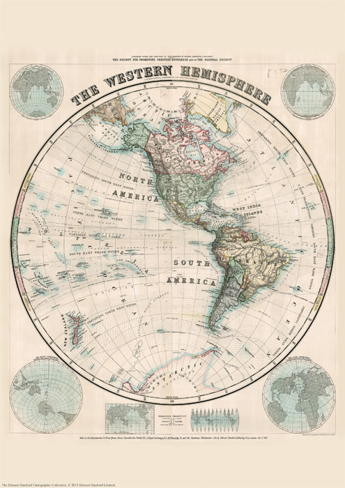
Print on Demand map from the Edward Stanford Cartographic Collection archive.The Stanford’s Map of The Western Hemisphere is from a fascinating series of reproductions from our Edward Stanford Cartographic Collection archive.The original map from 1877 was drawn by Stanford’s Geographical Establishment and ‘published under the direction of the Committee of General Literature and Education Appointed
Stanford`s Western Hemisphere Map (1877) – A1 Wall Map, Canvas

THIS ITEM IS AVAILABLE FOR CLICK AND COLLECT BUT PLEASE ALLOW UP TO 5 WORKING DAYS FOR THE PRINT TO BE PRODUCED. WE WILL EMAIL YOU CONFIRMATION WHEN THE ITEM IS READY FOR COLLECTION.The Stanford’s Map of The Western Hemisphere is from a fascinating series of reproductions from our Edward Stanford Cartographic Collection archive.The original
Stanford`s Western Hemisphere Map (1877) – Original Size Wall Map, Paper

The Stanford’s Map of The Western Hemisphere is from a fascinating series of reproductions from our Edward Stanford Cartographic Collection archive.The original map from 1877 was drawn by Stanford’s Geographical Establishment and ‘published under the direction of the Committee of General Literature and Education Appointed by The Society for Promoting Christian Knowledge and of the


