Category Archives: Maps
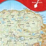
Ukraine – Moldova Wall Map

Ukraine with Moldova Wall Map at 1:1,100,000 from Gizi Map, size 120 x 88cm (47″ x 35″ approx), with an enlargement showing southern Crimea in greater detail, plus street plans of central Kiev and Lviv. All place names are shown transliterated into Latin alphabet, with those of major cities also given in their Cyrillic versions.Altitude
Africa Central & South – Madagascar WATERPROOF
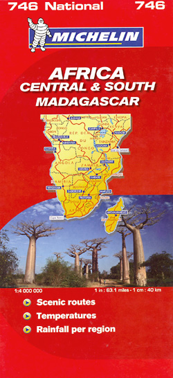
Central and Southern Africa at 1:4,000,000 – laminated, waterproof and tear-resistant version – in Michelin’s series covering the continent on three maps excellent for long-distance overland traveling or route planning, with detailed road classification, plenty of geographical features and a very comprehensive climate chart listing several locations. Coverage starts north of Yaoundรฉ in Cameroon, Bangui
Oman and United Arab Emirates Wall Map

Oman and United Arab Emirates Wall Map at 1:1,250,000 from Gizi Map, size 74 x 94cm (29″ x 37″ approx), with excellent presentation of the topography, many place names in both Arabic and Latin script, oil or gas rigs and pipelines in the southern Persian Gulf, etc.Bold altitude colouring shows the topography, with additional graphics
Iran Wall Map

Iran Wall Map at 1:2,000,000 from Gizi Map, size 98 x 88cm (39″ x 35″ approx) with bold altitude colouring to show its topography, provincial boundaries and an additional inset showing the administrative division into provinces, road and rail networks, places of interest, etc.Coverage extends west to include eastern Iraq with Baghdad, Kirkuk and Najaf,
Macedonia Wall Map

Macedonia Wall Map at 1:250,000 from Gizi Map, size 100 x 68cm (39.5″ x 27″ approx) with a street plan of central Skopje. The map offers excellent presentation of the country’s topography through relief shading, altitude colouring, peak heights and plenty of names of mountain ranges.Road network includes local roads and tracks, shows driving distances
China South Wall Map

Southern China Wall Map at 1:2,000,000 from Gizi Map, size 124 x 88cm (49″ x 35″ approx), with altitude colouring to show the region’s topography. Coverage extends north to Shanghai and Nanjing. Names of larger towns and the provinces are also given in Chinese.The map has bold altitude colouring, with spot heights and names of
Syria Gizi Wall Map

Syria Wall Map at 1:750,000 from Gizi Map, size 100 x 87cm (39″ x 34″ approx), with excellent presentation of the country’s topography, road infrastructure and oil/gas pipelines, enlargements for the environs of Damascus and Aleppo, street plans of these two cities – each with a more detailed plan of its Old City district, plus

Libya Road Edition Wall Map

Libya Road Edition Wall Map at 1:1.750,000 from Gizi Map, size 97 x 87cm (38″ x 34″ approx), with very fine presentation of its physical geography, oil and gas wells and pipelines, water aqueducts, ancients sites and other places of interest, etc. Names of larger towns and selected smaller locations, as well as of many
Scotland Michelin Regional 501 WATERPROOF

Scotland at 1:400,000 on an indexed touring map from Michelin – laminated version – particularly good for indentifying scenic routes. The whole country is shown on one side of the map, with coverage extending south to include Newcastle and most of the Lake District. Enlargement show the Glasgow area (1:200,000) and main roads across Edinburgh
Owerri – Imo State Road Map

Owerri street plan with an index of streets plus key buildings and facilities on a double-sided map from MDZ Multimedia, with on the reverse a road map of the Imo state at 1:150,000 and an administrative map of Nigeria.On one side is a street plan of Owerri with names of main roads and many smaller
Mongolia Geographical Edition Wall Map

Mongolia Geographical Edition Wall Map at 1:2,000,000 from Gizi Map, size 124 x 83cm (49″ x 33″ approx), with its road network shown on the base with bold altitude colouring indicating its physical geography. Names of larger towns and selected smaller locations, as well as of many topographic features are also shown in Cyrillic alphabet.The
Mongolia Road Edition Wall Map

Mongolia Road Edition Wall map at 1:2,000,000 from Gizi Map, size 124 x 67cm (49″ x 27″ approx), with its road network presented on a base with relief shading showing the country’s physical geography. Names of larger towns and selected smaller locations, as well as of many topographic features are also shown in Cyrillic alphabet.The
Caucasus Road Edition Wall Map

The Caucasus wall map at 1:1,000,000 from Gizi Map, size 117 x 82cm (46″ x 32″ approx), presenting the region in a road edition with relief shading to show its topography and make the road network stand out better against the background. Coverage includes the southern republics of Russia. International boundaries are clearly marked. Within
Caucasus Geographical Edition Wall Map
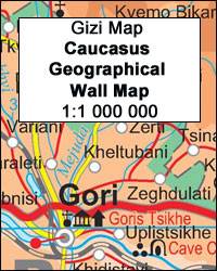
The Caucasus wall map at 1:1,000,000, size 117 x 82cm (46″ x 32″ approx), from Gizi Map, presenting the region in a geographical edition with bright altitude coloring to show its topography. Coverage includes the southern republics of Russia.International boundaries are clearly marked. Within Georgia the map indicates the boundaries of South Ossetia, Abkhazia and
Tibet Road Edition Wall Map
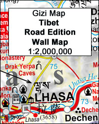
Tibet Road Edition Wall Map at 1:2,000,000 from Gizi Map, size 124 x 84cm )49″ x 33″ approx), presenting the region with relief shading to show its topography. Names of many settlements are shown in two or three versions: in the Latin alphabet transliteration of the Chinese and the Tibetan versions, plus for larger places
Central Asia Road Edition Wall Map

Central Asia Road Edition Wall Map at 1:1,750,000, size 121 x 81cm / 47.5″ x 32″ approx. Gizi Map coverage of Central Asia is available either in a geographical version or in a road edition and includes Uzbekistan, Kyrgyzstan, Tajikistan, plus southern Kazakhstan and most of Turkmenistan.Both versions show the region’s rail and road networks,
Central Asia Geographical Edition Wall Map
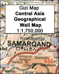
Central Asia Geographical Edition Wall Map at 1:1,750,000, size 121 x 81cm / 47.5″ x 32″ approx. Gizi Map coverage of Central Asia is available either in a geographical version or in a road edition and includes Uzbekistan, Kyrgyzstan, Tajikistan, plus southern Kazakhstan and most of Turkmenistan.Both versions show the region’s rail and road networks,
Kazakhstan Political Wall Map

Kazakhstan Political Wall Map at 1:3,000,000 from Gizi Map, size 120 x 88 cm / 47″ x 34.5″ approx, with different background colouring for all the countries covered by the map, an index of localities on the reverse, plus a street plan of Astana showing locations of important buildings, hotels, etc.The map provides good coverage
Kosovo Gizi Wall Map

Kosovo Wall Map at 1:250,000 from Gizi Map, size 100 x 68.5cm (39.5″ x 27″ approx)., showing place names in their Albanian and Serbian versions, with a separate index for each set of names. Serbian names, both in Kosovo and in the adjoining parts of Serbia and Macedonia, are given in the Latin alphabet.Bold altitude