Category Archives: Maps
China North-West Wall Map
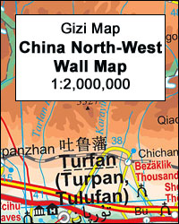
North-West China Wall Map at 1:2,000,000 from Gizi Map, size 99 x 89 cm (39″ x 35″ approx), with attractive presentation of the region’s varied topography, traditional local alternatives to Chinese place names, plus a street plan of รrรผmchi.Bold altitude colouring with graphics for deserts, yardangs, salt flats, etc, and plenty of names of mountain
Ethiopia – Eritrea – Djibouti Wall Map

Ethiopia – Eritrea – Djibouti Wall Map at 1:2,000,000 from Gizi Map, size 98 x 92cm (38.5″ x 36″ approx) with excellent, vivid presentation of the region’s topography, a street plan of central Adis Abeba, plus enlargements of the capital’s environs and the Simen National Park. Coverage includes Eritrea and Djibouti, extending across the Red
Somalia Wall Map

Somalia Wall Map at 1:1,750,000 from Gizi Map, size 86 x 94cm (34″ x 38″ approx.), covering the whole territory within the internationally recognized borders of the country and showing its current (autumn 2012) de facto division into Somaliland and Somalia, as well as the self-proclaimed autonomous states within Somalia: Puntland, Galmudug and Jubaland, plus
Mauritania Wall Map

Mauritania and Western Sahara Wall Map at 1:1,750,000 from Gizi Map, size 95 x 88cm (37.5″ x 34.5″), with excellent presentation of the country’s topography, an index next to the map, plus a street plan of central Nouakchot. Vivid altitude colouring with graphics for deserts, flood plains and salt flats shows the terrain. Oases, water
Vatican City Wall Map
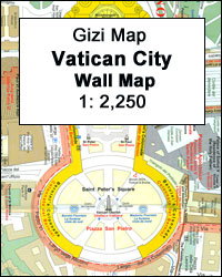
The Vatican and the adjoining districts of Rome with Castel Sant’Angelo on a detailed, informative and beautifully presented wall map, size 98 x 67.5cm (39″ x 27.5″ approx), from Gizi Map with additional plans of Saint Peter’s, the ceiling in the Sistine Chapel, the grotto with papal tombs, etc.The street plan is drawn at 1:2,250
Island of Menorca – Brigadier Don Vincent Tofino 1812
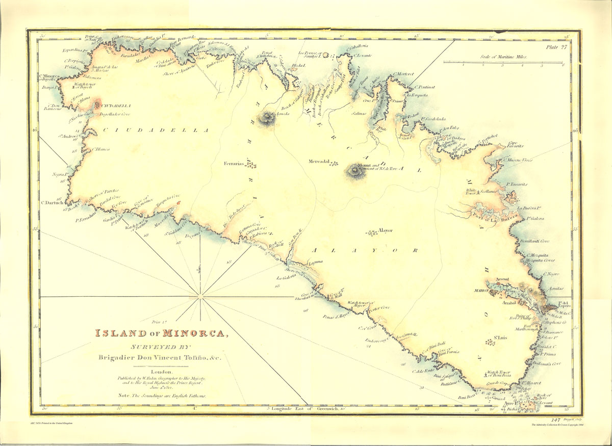
Admiralty Collection is a range of beautiful historic chart replicas from UK Hydrographic Office Archive in Taunton, Somerset.Admiralty have now discontinued this series. The maps listed here are the last remaining copies and unfortunately we will not be able to order more. If you need any further information or help choosing a print, you can
Andhra Pradesh

Indian state of Andhra Pradesh on road map from the Delhi-based International Publications, showing many small towns and villages. Please note that, unlike most other titles in this series, this one comes without an accompanying booklet.Additional features around the main map include a physical maps of the state, plus small maps showing annual rainfall, cash
Hanover in 3-D Street Plan

Unusual, very attractive street plan of Hannover from Bollmann, offering a bird’s-eye view of the city with every building drawn to scale with full architectural detail, from street arcades to rooftops and inner courtyards. The plan, drawn in 2010, covers central Hannover from the AWD Arena and Waterlooplatz in the west to the Stadthalle in
Mali Wall Map

Mali Wall Map at 1:2,000,000 from Gizi Map, size 95.5 x 88cm ( 38″ x 35″ approx,) with excellent presentation of the country’s topography, plus an enlargement for the Dogon Plateau and street plans of Bamako and Timbuktu, all showing places of interest.Topography is shown by altitude colouring with spot heights and plenty of names
Bamberg in 3-D Street Plan

Unusual, very attractive street plan of Bamberg offering a bird’s-eye view of the city with every building drawn to scale with full architectural detail, from street arcades to rooftops and inner courtyards. The plan, updated in 2009, covers the city’s inner districts and is annotated with small icons of various businesses which sponsored its production.On
Svalbard Topographic Map

The Svalbard Archipelago: Spitsbergen, Nordaustlandet, Edgeoya and the smaller islands at 1:1,000,000 from the Norsk Polarinstitutt showing the topography, settlements, airfields, etc. The same map is available in two different versions: topographic edition and tourist version.The map itself is the same in both versions and presets the topography by contours at 200m intervals plus spot
Aachen in 3-D Street Plan
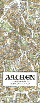
Unusual, very attractive street plan of Aachen offering a bird’s-eye view of the city with every building drawn to scale with full architectural detail, from street arcades to rooftops and inner courtyards. The plan, updated in 2015, covers Aachen’s central districts between the city’s main railway stations, the Westbanhof and the Casino, and is annotated
Oglala National Grassland, Nebraska National Forest and Samuel R. McKelvie National Forest

Oglala National Grassland, Nebraska National Forest and Samuel R. McKelvie National Forest, three separate forest areas of Nebraska on a map at 1:126,720 from the US Forest Service, each presented as a separate panel.Colouring indicates areas designated as National Forest and Grassland, plus adjacent National Grassland areas, land administered by Bureau of Land Managements (BLM),
Dusseldorf in 3-D Street Plan
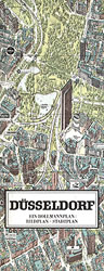
Unusual, very attractive street plan of Dรผsseldorf from Bollmann, offering a bird’s-eye view of the city with every building drawn to scale with full architectural detail, from street arcades to rooftops and inner courtyards. The plan, drawn in 2009, covers central Dรผsseldorf from the main railway station across the Rhine to the Oberkassel area and
Stuttgart in 3-D Street Plan
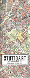
Unusual, very attractive street plan of Stuttgart from Bollmann, offering a bird’s-eye view of the city with every building drawn to scale with full architectural detail, from street arcades to rooftops and inner courtyards. The plan, drawn in 2008, covers Stuttgart’s central districts and is annotated with small icons of various businesses which sponsored its
Bishkek Street Plan

Bishkek street plan from the locally based Rarity publishers, with a map of the whole city and a very detailed street plan of the city centre, a map of the Chuy region and lists of numerous services and facilities including hotels, restaurants, etc.On one side is a street plan of the whole of Bishkek highlighting
New Zealand Wall Map
New Zealand Wall Map at 1:1,700,000 fro Gizi Map, size 73.5 x 93.5cm (29″ x 36.5″ approx), presenting an excellent picture of the country’s topography, road network and places of interest, with insets showing the division into administrative regions, plus New Zealand’s position in the South Pacific.The map had altitude colouring with spot heights and
China Central Wall Map

Central China Wall Map at 1:2,000,000 from Gizi Map, size 124 x 88cm (49″ x 34.5″ approx), with attractive presentation of the region’s varied topography, tourist sights including the Great Wall, and coverage from Shenyang to Shanghai.Bold altitude colouring with plenty of names of mountain ranges and other geographical features, peak heights, etc, provides an
China North-East Wall Map

North-East China Wall Map at 1:2,000,000 from Gizi Map, size 97 x 88cm (38″ x 34.5″ approx), with attractive presentation of the region’s varied topography, tourist sights including the Great Wall, and coverage extending south to include Beijing.Bold altitude colouring with plenty of names of mountain ranges and other geographical features, peak heights, etc, provides