Category Archives: Maps
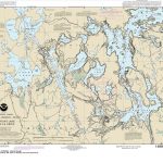
Tamiahua
Topographic mapping from Mexico’s national survey agency, Instituto Nacional de Estadรญstica, Geografรญa e Informรกtica. The maps have contours at 20m intervals with relief shading and indicate various types of terrain and vegetation, e.g. dense vegetation, cultivated areas, swamps, sand dunes, salt pans, etc. UTM grid is at 10km intervals, with latitude and longitude shown by
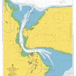
Tampico
Topographic mapping from Mexico’s national survey agency, Instituto Nacional de Estadรญstica, Geografรญa e Informรกtica. The maps have contours at 20m intervals with relief shading and indicate various types of terrain and vegetation, e.g. dense vegetation, cultivated areas, swamps, sand dunes, salt pans, etc. UTM grid is at 10km intervals, with latitude and longitude shown by
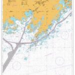
Tapachula
Topographic mapping from Mexico’s national survey agency, Instituto Nacional de Estadรญstica, Geografรญa e Informรกtica. The maps have contours at 20m intervals with relief shading and indicate various types of terrain and vegetation, e.g. dense vegetation, cultivated areas, swamps, sand dunes, salt pans, etc. UTM grid is at 10km intervals, with latitude and longitude shown by
Tecoripa
Topographic mapping from Mexico’s national survey agency, Instituto Nacional de Estadรญstica, Geografรญa e Informรกtica. The maps have contours at 20m intervals with relief shading and indicate various types of terrain and vegetation, e.g. dense vegetation, cultivated areas, swamps, sand dunes, salt pans, etc. UTM grid is at 10km intervals, with latitude and longitude shown by
Tijuana
Topographic mapping from Mexico’s national survey agency, Instituto Nacional de Estadรญstica, Geografรญa e Informรกtica. The maps have contours at 20m intervals with relief shading and indicate various types of terrain and vegetation, e.g. dense vegetation, cultivated areas, swamps, sand dunes, salt pans, etc. UTM grid is at 10km intervals, with latitude and longitude shown by
Tizimin
Topographic mapping from Mexico’s national survey agency, Instituto Nacional de Estadรญstica, Geografรญa e Informรกtica. The maps have contours at 20m intervals with relief shading and indicate various types of terrain and vegetation, e.g. dense vegetation, cultivated areas, swamps, sand dunes, salt pans, etc. UTM grid is at 10km intervals, with latitude and longitude shown by
Tlahualilo de Zaragoza
Topographic mapping from Mexico’s national survey agency, Instituto Nacional de Estadรญstica, Geografรญa e Informรกtica. The maps have contours at 20m intervals with relief shading and indicate various types of terrain and vegetation, e.g. dense vegetation, cultivated areas, swamps, sand dunes, salt pans, etc. UTM grid is at 10km intervals, with latitude and longitude shown by
Rio Bravo
Topographic mapping from Mexico’s national survey agency, Instituto Nacional de Estadรญstica, Geografรญa e Informรกtica. The maps have contours at 20m intervals with relief shading and indicate various types of terrain and vegetation, e.g. dense vegetation, cultivated areas, swamps, sand dunes, salt pans, etc. UTM grid is at 10km intervals, with latitude and longitude shown by
Torreon
Topographic mapping from Mexico’s national survey agency, Instituto Nacional de Estadรญstica, Geografรญa e Informรกtica. The maps have contours at 20m intervals with relief shading and indicate various types of terrain and vegetation, e.g. dense vegetation, cultivated areas, swamps, sand dunes, salt pans, etc. UTM grid is at 10km intervals, with latitude and longitude shown by
San Antonio del Bravo
Topographic mapping from Mexico’s national survey agency, Instituto Nacional de Estadรญstica, Geografรญa e Informรกtica. The maps have contours at 20m intervals with relief shading and indicate various types of terrain and vegetation, e.g. dense vegetation, cultivated areas, swamps, sand dunes, salt pans, etc. UTM grid is at 10km intervals, with latitude and longitude shown by
Tuxtla Gutierrez
Topographic mapping from Mexico’s national survey agency, Instituto Nacional de Estadรญstica, Geografรญa e Informรกtica. The maps have contours at 20m intervals with relief shading and indicate various types of terrain and vegetation, e.g. dense vegetation, cultivated areas, swamps, sand dunes, salt pans, etc. UTM grid is at 10km intervals, with latitude and longitude shown by
San Felipe
Topographic mapping from Mexico’s national survey agency, Instituto Nacional de Estadรญstica, Geografรญa e Informรกtica. The maps have contours at 20m intervals with relief shading and indicate various types of terrain and vegetation, e.g. dense vegetation, cultivated areas, swamps, sand dunes, salt pans, etc. UTM grid is at 10km intervals, with latitude and longitude shown by
Veracruz
Topographic mapping from Mexico’s national survey agency, Instituto Nacional de Estadรญstica, Geografรญa e Informรกtica. The maps have contours at 20m intervals with relief shading and indicate various types of terrain and vegetation, e.g. dense vegetation, cultivated areas, swamps, sand dunes, salt pans, etc. UTM grid is at 10km intervals, with latitude and longitude shown by
Nueva Casas Grandes
Topographic mapping from Mexico’s national survey agency, Instituto Nacional de Estadรญstica, Geografรญa e Informรกtica. The maps have contours at 20m intervals with relief shading and indicate various types of terrain and vegetation, e.g. dense vegetation, cultivated areas, swamps, sand dunes, salt pans, etc. UTM grid is at 10km intervals, with latitude and longitude shown by
Nuevo Laredo
Topographic mapping from Mexico’s national survey agency, Instituto Nacional de Estadรญstica, Geografรญa e Informรกtica. The maps have contours at 20m intervals with relief shading and indicate various types of terrain and vegetation, e.g. dense vegetation, cultivated areas, swamps, sand dunes, salt pans, etc. UTM grid is at 10km intervals, with latitude and longitude shown by
Ocampo
Topographic mapping from Mexico’s national survey agency, Instituto Nacional de Estadรญstica, Geografรญa e Informรกtica. The maps have contours at 20m intervals with relief shading and indicate various types of terrain and vegetation, e.g. dense vegetation, cultivated areas, swamps, sand dunes, salt pans, etc. UTM grid is at 10km intervals, with latitude and longitude shown by
Ojinaga
Topographic mapping from Mexico’s national survey agency, Instituto Nacional de Estadรญstica, Geografรญa e Informรกtica. The maps have contours at 20m intervals with relief shading and indicate various types of terrain and vegetation, e.g. dense vegetation, cultivated areas, swamps, sand dunes, salt pans, etc. UTM grid is at 10km intervals, with latitude and longitude shown by
Pachuca
Topographic mapping from Mexico’s national survey agency, Instituto Nacional de Estadรญstica, Geografรญa e Informรกtica. The maps have contours at 20m intervals with relief shading and indicate various types of terrain and vegetation, e.g. dense vegetation, cultivated areas, swamps, sand dunes, salt pans, etc. UTM grid is at 10km intervals, with latitude and longitude shown by
Pericos
Topographic mapping from Mexico’s national survey agency, Instituto Nacional de Estadรญstica, Geografรญa e Informรกtica. The maps have contours at 20m intervals with relief shading and indicate various types of terrain and vegetation, e.g. dense vegetation, cultivated areas, swamps, sand dunes, salt pans, etc. UTM grid is at 10km intervals, with latitude and longitude shown by
Piedras Negras
Topographic mapping from Mexico’s national survey agency, Instituto Nacional de Estadรญstica, Geografรญa e Informรกtica. The maps have contours at 20m intervals with relief shading and indicate various types of terrain and vegetation, e.g. dense vegetation, cultivated areas, swamps, sand dunes, salt pans, etc. UTM grid is at 10km intervals, with latitude and longitude shown by