Category Archives: Maps
Arvika
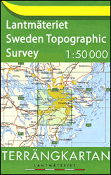
Topographic survey of Sweden at 1:50,000, the Terrรคngkartan, from the Lantmรคteriet, covering most of the country in 244 double-sided maps. Please note: the mountainous regions of central and northern Sweden are not covered by this series but presented in a separate ‘Fjรคllkartan – Mountain Map” series also listed on our website.Each 1:50,000 topographic survey map
Svenska Hรถgarna

Topographic survey of Sweden at 1:50,000, the Terrรคngkartan, from the Lantmรคteriet, covering most of the country in 244 double-sided maps. Please note: the mountainous regions of central and northern Sweden are not covered by this series but presented in a separate ‘Fjรคllkartan – Mountain Map” series also listed on our website.Each 1:50,000 topographic survey map
Koppom

Topographic survey of Sweden at 1:50,000, the Terrรคngkartan, from the Lantmรคteriet, covering most of the country in 244 double-sided maps. Please note: the mountainous regions of central and northern Sweden are not covered by this series but presented in a separate ‘Fjรคllkartan – Mountain Map” series also listed on our website.Each 1:50,000 topographic survey map
Sunne

Topographic survey of Sweden at 1:50,000, the Terrรคngkartan, from the Lantmรคteriet, covering most of the country in 244 double-sided maps. Please note: the mountainous regions of central and northern Sweden are not covered by this series but presented in a separate ‘Fjรคllkartan – Mountain Map” series also listed on our website.Each 1:50,000 topographic survey map
Vรคsterรฅs

Topographic survey of Sweden at 1:50,000, the Terrรคngkartan, from the Lantmรคteriet, covering most of the country in 244 double-sided maps. Please note: the mountainous regions of central and northern Sweden are not covered by this series but presented in a separate ‘Fjรคllkartan – Mountain Map” series also listed on our website.Each 1:50,000 topographic survey map
Filipstad

Topographic survey of Sweden at 1:50,000, the Terrรคngkartan, from the Lantmรคteriet, covering most of the country in 244 double-sided maps. Please note: the mountainous regions of central and northern Sweden are not covered by this series but presented in a separate ‘Fjรคllkartan – Mountain Map” series also listed on our website.Each 1:50,000 topographic survey map
Uppsala

Topographic survey of Sweden at 1:50,000, the Terrรคngkartan, from the Lantmรคteriet, covering most of the country in 244 double-sided maps. Please note: the mountainous regions of central and northern Sweden are not covered by this series but presented in a separate ‘Fjรคllkartan – Mountain Map” series also listed on our website.Each 1:50,000 topographic survey map
Hรคllefors

Topographic survey of Sweden at 1:50,000, the Terrรคngkartan, from the Lantmรคteriet, covering most of the country in 244 double-sided maps. Please note: the mountainous regions of central and northern Sweden are not covered by this series but presented in a separate ‘Fjรคllkartan – Mountain Map” series also listed on our website.Each 1:50,000 topographic survey map
Lindesberg

Topographic survey of Sweden at 1:50,000, the Terrรคngkartan, from the Lantmรคteriet, covering most of the country in 244 double-sided maps. Please note: the mountainous regions of central and northern Sweden are not covered by this series but presented in a separate ‘Fjรคllkartan – Mountain Map” series also listed on our website.Each 1:50,000 topographic survey map
Hallstahammar

Topographic survey of Sweden at 1:50,000, the Terrรคngkartan, from the Lantmรคteriet, covering most of the country in 244 double-sided maps. Please note: the mountainous regions of central and northern Sweden are not covered by this series but presented in a separate ‘Fjรคllkartan – Mountain Map” series also listed on our website.Each 1:50,000 topographic survey map
Enkรถping

Topographic survey of Sweden at 1:50,000, the Terrรคngkartan, from the Lantmรคteriet, covering most of the country in 244 double-sided maps. Please note: the mountainous regions of central and northern Sweden are not covered by this series but presented in a separate ‘Fjรคllkartan – Mountain Map” series also listed on our website.Each 1:50,000 topographic survey map
Norrtalje

Topographic survey of Sweden at 1:50,000, the Terrรคngkartan, from the Lantmรคteriet, covering most of the country in 244 double-sided maps. Please note: the mountainous regions of central and northern Sweden are not covered by this series but presented in a separate ‘Fjรคllkartan – Mountain Map” series also listed on our website.Each 1:50,000 topographic survey map
Sรถderarm

Topographic survey of Sweden at 1:50,000, the Terrรคngkartan, from the Lantmรคteriet, covering most of the country in 244 double-sided maps. Please note: the mountainous regions of central and northern Sweden are not covered by this series but presented in a separate ‘Fjรคllkartan – Mountain Map” series also listed on our website.Each 1:50,000 topographic survey map
Charlottenberg

Topographic survey of Sweden at 1:50,000, the Terrรคngkartan, from the Lantmรคteriet, covering most of the country in 244 double-sided maps. Please note: the mountainous regions of central and northern Sweden are not covered by this series but presented in a separate ‘Fjรคllkartan – Mountain Map” series also listed on our website.Each 1:50,000 topographic survey map
Uddheden

Topographic survey of Sweden at 1:50,000, the Terrรคngkartan, from the Lantmรคteriet, covering most of the country in 244 double-sided maps. Please note: the mountainous regions of central and northern Sweden are not covered by this series but presented in a separate ‘Fjรคllkartan – Mountain Map” series also listed on our website.Each 1:50,000 topographic survey map
Torsby

Topographic survey of Sweden at 1:50,000, the Terrรคngkartan, from the Lantmรคteriet, covering most of the country in 244 double-sided maps. Please note: the mountainous regions of central and northern Sweden are not covered by this series but presented in a separate ‘Fjรคllkartan – Mountain Map” series also listed on our website.Each 1:50,000 topographic survey map
Fredriksberg

Topographic survey of Sweden at 1:50,000, the Terrรคngkartan, from the Lantmรคteriet, covering most of the country in 244 double-sided maps. Please note: the mountainous regions of central and northern Sweden are not covered by this series but presented in a separate ‘Fjรคllkartan – Mountain Map” series also listed on our website.Each 1:50,000 topographic survey map
Ludvika

Topographic survey of Sweden at 1:50,000, the Terrรคngkartan, from the Lantmรคteriet, covering most of the country in 244 double-sided maps. Please note: the mountainous regions of central and northern Sweden are not covered by this series but presented in a separate ‘Fjรคllkartan – Mountain Map” series also listed on our website.Each 1:50,000 topographic survey map
Mรถja

Topographic survey of Sweden at 1:50,000, the Terrรคngkartan, from the Lantmรคteriet, covering most of the country in 244 double-sided maps. Please note: the mountainous regions of central and northern Sweden are not covered by this series but presented in a separate ‘Fjรคllkartan – Mountain Map” series also listed on our website.Each 1:50,000 topographic survey map
Avesta

Topographic survey of Sweden at 1:50,000, the Terrรคngkartan, from the Lantmรคteriet, covering most of the country in 244 double-sided maps. Please note: the mountainous regions of central and northern Sweden are not covered by this series but presented in a separate ‘Fjรคllkartan – Mountain Map” series also listed on our website.Each 1:50,000 topographic survey map


