Category Archives: Maps
Houffalize NGI Topo 60/3-4
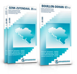
Topographical survey of Belgium at 1:20,000 from Nationaal Geografisch Instituut / Institut Gรฉographique National, the country’s national survey organization. Each 20K map covers one quarter of the corresponding 1:50,000 map (with adjustments in the border and coastal areas). The maps provide all the information expected of topographic mapping at this scale and additionally have an
Sainte-Ode NGI Topo 60/5-6

Topographical survey of Belgium at 1:20,000 from Nationaal Geografisch Instituut / Institut Gรฉographique National, the country’s national survey organization. Each 20K map covers one quarter of the corresponding 1:50,000 map (with adjustments in the border and coastal areas). The maps provide all the information expected of topographic mapping at this scale and additionally have an
Bertogne NGI Topo 60/7-8

Topographical survey of Belgium at 1:20,000 from Nationaal Geografisch Instituut / Institut Gรฉographique National, the country’s national survey organization. Each 20K map covers one quarter of the corresponding 1:50,000 map (with adjustments in the border and coastal areas). The maps provide all the information expected of topographic mapping at this scale and additionally have an
Hannut NGI Topo 41/1-2

Topographical survey of Belgium at 1:20,000 from Nationaal Geografisch Instituut / Institut Gรฉographique National, the country’s national survey organization. Each 20K map covers one quarter of the corresponding 1:50,000 map (with adjustments in the border and coastal areas). The maps provide all the information expected of topographic mapping at this scale and additionally have an
Genk NGI Topo 26

Topographical survey of Belgium at 1:50,000 from the country’s national survey organization, Nationaal Geografisch Instituut / Institut Gรฉographique National. Contour interval varies according to the terrain, from 2.5 metres in the coastal areas to 10 metres in the Ardennes. The maps provide all the information expected of topographic mapping at this scale and additionally have
Waremme NGI Topo 41/3-4

Topographical survey of Belgium at 1:20,000 from Nationaal Geografisch Instituut / Institut Gรฉographique National, the country’s national survey organization. Each 20K map covers one quarter of the corresponding 1:50,000 map (with adjustments in the border and coastal areas). The maps provide all the information expected of topographic mapping at this scale and additionally have an
Liรจge NGI Topo 42

Topographical survey of Belgium at 1:50,000 from the country’s national survey organization, Nationaal Geografisch Instituut / Institut Gรฉographique National. Contour interval varies according to the terrain, from 2.5 metres in the coastal areas to 10 metres in the Ardennes. The maps provide all the information expected of topographic mapping at this scale and additionally have
Braives NGI Topo 41/5-6

Topographical survey of Belgium at 1:20,000 from Nationaal Geografisch Instituut / Institut Gรฉographique National, the country’s national survey organization. Each 20K map covers one quarter of the corresponding 1:50,000 map (with adjustments in the border and coastal areas). The maps provide all the information expected of topographic mapping at this scale and additionally have an
Namur NGI Topo 47

Topographical survey of Belgium at 1:50,000 from the country’s national survey organization, Nationaal Geografisch Instituut / Institut Gรฉographique National. Contour interval varies according to the terrain, from 2.5 metres in the coastal areas to 10 metres in the Ardennes. The maps provide all the information expected of topographic mapping at this scale and additionally have
Saint-Georges-sur-Meuse NGI Topo 41/7-8

Topographical survey of Belgium at 1:20,000 from Nationaal Geografisch Instituut / Institut Gรฉographique National, the country’s national survey organization. Each 20K map covers one quarter of the corresponding 1:50,000 map (with adjustments in the border and coastal areas). The maps provide all the information expected of topographic mapping at this scale and additionally have an
Huy NGI Topo 48
Topographical survey of Belgium at 1:50,000 from the country’s national survey organization, Nationaal Geografisch Instituut / Institut Gรฉographique National. Contour interval varies according to the terrain, from 2.5 metres in the coastal areas to 10 metres in the Ardennes. The maps provide all the information expected of topographic mapping at this scale and additionally have
La Louviere NGI Topo 46/1-2

Topographical survey of Belgium at 1:20,000 from Nationaal Geografisch Instituut / Institut Gรฉographique National, the country’s national survey organization. Each 20K map covers one quarter of the corresponding 1:50,000 map (with adjustments in the border and coastal areas). The maps provide all the information expected of topographic mapping at this scale and additionally have an
Quevy NGI Topo Map 51

Topographical survey of Belgium at 1:50,000 from the country’s national survey organization, Nationaal Geografisch Instituut / Institut Gรฉographique National. Contour interval varies according to the terrain, from 2.5 metres in the coastal areas to 10 metres in the Ardennes. The maps provide all the information expected of topographic mapping at this scale and additionally have
Thuin NGI Topo 52

Topographical survey of Belgium at 1:50,000 from the country’s national survey organization, Nationaal Geografisch Instituut / Institut Gรฉographique National. Contour interval varies according to the terrain, from 2.5 metres in the coastal areas to 10 metres in the Ardennes. The maps provide all the information expected of topographic mapping at this scale and additionally have
Beauraing NGI Topo Map 58

Topographical survey of Belgium at 1:50,000 from the country’s national survey organization, Nationaal Geografisch Instituut / Institut Gรฉographique National. Contour interval varies according to the terrain, from 2.5 metres in the coastal areas to 10 metres in the Ardennes. The maps provide all the information expected of topographic mapping at this scale and additionally have
Heist-op-den-Berg NGI Topo 24/1-2

Topographical survey of Belgium at 1:20,000 from Nationaal Geografisch Instituut / Institut Gรฉographique National, the country’s national survey organization. Each 20K map covers one quarter of the corresponding 1:50,000 map (with adjustments in the border and coastal areas). The maps provide all the information expected of topographic mapping at this scale and additionally have an
Herselt NGI Topo 24/3-4

Topographical survey of Belgium at 1:20,000 from Nationaal Geografisch Instituut / Institut Gรฉographique National, the country’s national survey organization. Each 20K map covers one quarter of the corresponding 1:50,000 map (with adjustments in the border and coastal areas). The maps provide all the information expected of topographic mapping at this scale and additionally have an
Haacht NGI Topo 24/5-6

Topographical survey of Belgium at 1:20,000 from Nationaal Geografisch Instituut / Institut Gรฉographique National, the country’s national survey organization. Each 20K map covers one quarter of the corresponding 1:50,000 map (with adjustments in the border and coastal areas). The maps provide all the information expected of topographic mapping at this scale and additionally have an
Aarschot NGI Topo 24/7-8

Topographical survey of Belgium at 1:20,000 from Nationaal Geografisch Instituut / Institut Gรฉographique National, the country’s national survey organization. Each 20K map covers one quarter of the corresponding 1:50,000 map (with adjustments in the border and coastal areas). The maps provide all the information expected of topographic mapping at this scale and additionally have an
Lessines NGI 38/1-2

Topographical survey of Belgium at 1:20,000 from Nationaal Geografisch Instituut / Institut Gรฉographique National, the country’s national survey organization. Each 20K map covers one quarter of the corresponding 1:50,000 map (with adjustments in the border and coastal areas). The maps provide all the information expected of topographic mapping at this scale and additionally have an


