Category Archives: Accessories
Ranttila
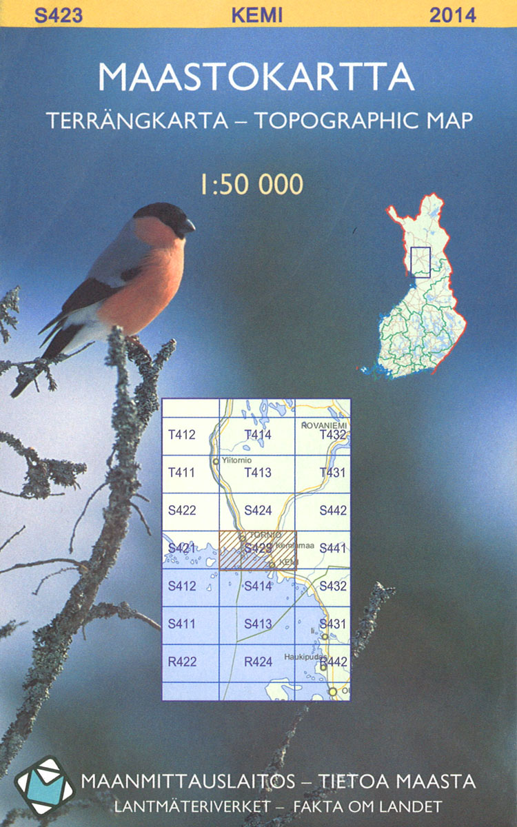
The 1:50 000 topographic map gives a more general picture of the ground features than a basic map. It shows settlements, houses, roads, cultivated areas, waterways, cutting areas, mires, rock exposures, and relief. One map sheet covers an area of 30 x 40 km and one centimetre corresponds to 500 metres on the ground.The 1:50,000
Mutusjarvi
The 1:50 000 topographic map gives a more general picture of the ground features than a basic map. It shows settlements, houses, roads, cultivated areas, waterways, cutting areas, mires, rock exposures, and relief. One map sheet covers an area of 30 x 40 km and one centimetre corresponds to 500 metres on the ground.The 1:50,000
Kamiljoki
The 1:50 000 topographic map gives a more general picture of the ground features than a basic map. It shows settlements, houses, roads, cultivated areas, waterways, cutting areas, mires, rock exposures, and relief. One map sheet covers an area of 30 x 40 km and one centimetre corresponds to 500 metres on the ground.The 1:50,000
Nammijarvi
The 1:50 000 topographic map gives a more general picture of the ground features than a basic map. It shows settlements, houses, roads, cultivated areas, waterways, cutting areas, mires, rock exposures, and relief. One map sheet covers an area of 30 x 40 km and one centimetre corresponds to 500 metres on the ground.The 1:50,000
Iijarvi
The 1:50 000 topographic map gives a more general picture of the ground features than a basic map. It shows settlements, houses, roads, cultivated areas, waterways, cutting areas, mires, rock exposures, and relief. One map sheet covers an area of 30 x 40 km and one centimetre corresponds to 500 metres on the ground.The 1:50,000
Nuorgam
The 1:50 000 topographic map gives a more general picture of the ground features than a basic map. It shows settlements, houses, roads, cultivated areas, waterways, cutting areas, mires, rock exposures, and relief. One map sheet covers an area of 30 x 40 km and one centimetre corresponds to 500 metres on the ground.The 1:50,000
Kesalahti
The 1:50 000 topographic map gives a more general picture of the ground features than a basic map. It shows settlements, houses, roads, cultivated areas, waterways, cutting areas, mires, rock exposures, and relief. One map sheet covers an area of 30 x 40 km and one centimetre corresponds to 500 metres on the ground.The 1:50,000
Mariehamn
The 1:50 000 topographic map gives a more general picture of the ground features than a basic map. It shows settlements, houses, roads, cultivated areas, waterways, cutting areas, mires, rock exposures, and relief. One map sheet covers an area of 30 x 40 km and one centimetre corresponds to 500 metres on the ground.The 1:50,000
Karigasniemi
The 1:50 000 topographic map gives a more general picture of the ground features than a basic map. It shows settlements, houses, roads, cultivated areas, waterways, cutting areas, mires, rock exposures, and relief. One map sheet covers an area of 30 x 40 km and one centimetre corresponds to 500 metres on the ground.The 1:50,000
Eckero
The 1:50 000 topographic map gives a more general picture of the ground features than a basic map. It shows settlements, houses, roads, cultivated areas, waterways, cutting areas, mires, rock exposures, and relief. One map sheet covers an area of 30 x 40 km and one centimetre corresponds to 500 metres on the ground.The 1:50,000
Paistunturit
The 1:50 000 topographic map gives a more general picture of the ground features than a basic map. It shows settlements, houses, roads, cultivated areas, waterways, cutting areas, mires, rock exposures, and relief. One map sheet covers an area of 30 x 40 km and one centimetre corresponds to 500 metres on the ground.The 1:50,000
Sottunga
The 1:50 000 topographic map gives a more general picture of the ground features than a basic map. It shows settlements, houses, roads, cultivated areas, waterways, cutting areas, mires, rock exposures, and relief. One map sheet covers an area of 30 x 40 km and one centimetre corresponds to 500 metres on the ground.The 1:50,000
Ylakongas
The 1:50 000 topographic map gives a more general picture of the ground features than a basic map. It shows settlements, houses, roads, cultivated areas, waterways, cutting areas, mires, rock exposures, and relief. One map sheet covers an area of 30 x 40 km and one centimetre corresponds to 500 metres on the ground.The 1:50,000
Kumlinge
The 1:50 000 topographic map gives a more general picture of the ground features than a basic map. It shows settlements, houses, roads, cultivated areas, waterways, cutting areas, mires, rock exposures, and relief. One map sheet covers an area of 30 x 40 km and one centimetre corresponds to 500 metres on the ground.The 1:50,000
Naatamo

The 1:50 000 topographic map gives a more general picture of the ground features than a basic map. It shows settlements, houses, roads, cultivated areas, waterways, cutting areas, mires, rock exposures, and relief. One map sheet covers an area of 30 x 40 km and one centimetre corresponds to 500 metres on the ground.The 1:50,000
Rannorarna
The 1:50 000 topographic map gives a more general picture of the ground features than a basic map. It shows settlements, houses, roads, cultivated areas, waterways, cutting areas, mires, rock exposures, and relief. One map sheet covers an area of 30 x 40 km and one centimetre corresponds to 500 metres on the ground.The 1:50,000
Kerava
The 1:50 000 topographic map gives a more general picture of the ground features than a basic map. It shows settlements, houses, roads, cultivated areas, waterways, cutting areas, mires, rock exposures, and relief. One map sheet covers an area of 30 x 40 km and one centimetre corresponds to 500 metres on the ground.The 1:50,000
Paatari
The 1:50 000 topographic map gives a more general picture of the ground features than a basic map. It shows settlements, houses, roads, cultivated areas, waterways, cutting areas, mires, rock exposures, and relief. One map sheet covers an area of 30 x 40 km and one centimetre corresponds to 500 metres on the ground.The 1:50,000
Kaamasmukka
The 1:50 000 topographic map gives a more general picture of the ground features than a basic map. It shows settlements, houses, roads, cultivated areas, waterways, cutting areas, mires, rock exposures, and relief. One map sheet covers an area of 30 x 40 km and one centimetre corresponds to 500 metres on the ground.The 1:50,000
Partakko
The 1:50 000 topographic map gives a more general picture of the ground features than a basic map. It shows settlements, houses, roads, cultivated areas, waterways, cutting areas, mires, rock exposures, and relief. One map sheet covers an area of 30 x 40 km and one centimetre corresponds to 500 metres on the ground.The 1:50,000