Category Archives: Accessories
Rautavaara

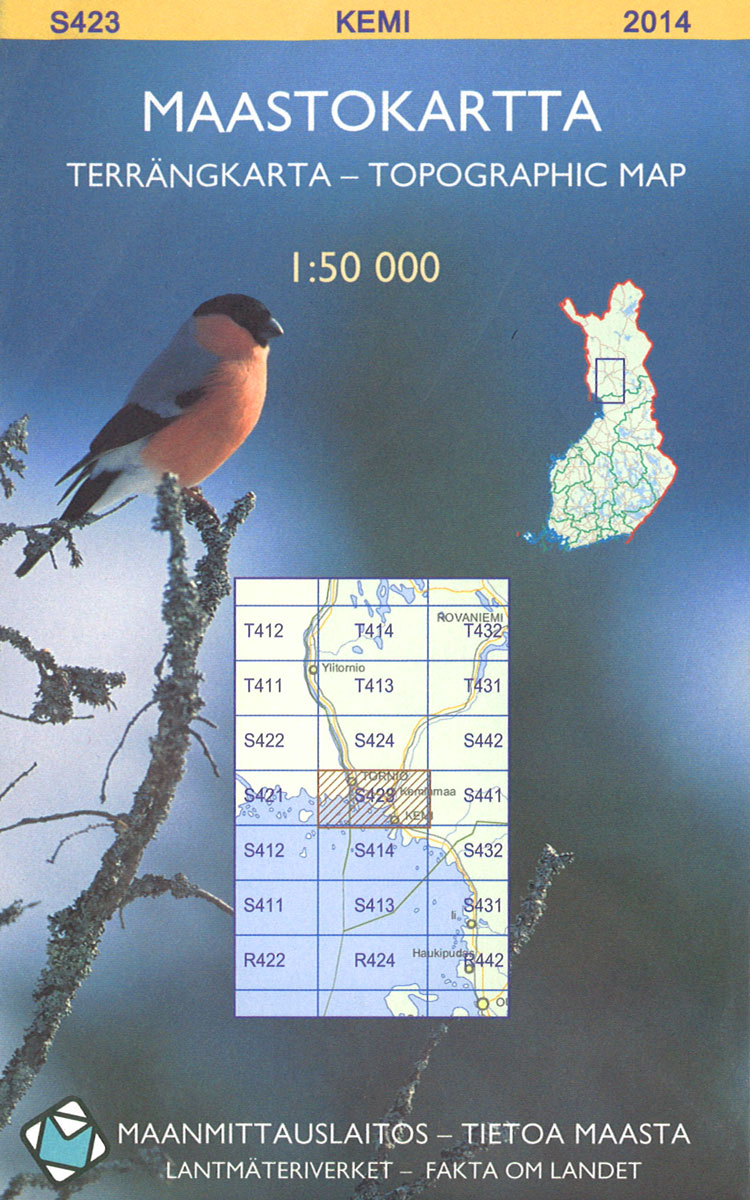
The 1:50,000 topographic map gives a more general picture of the ground features than a basic map. It shows settlements, houses, roads, cultivated areas, waterways, cutting areas, mires, rock exposures, and relief. One map sheet covers an area of 30 x 40 km and one centimetre corresponds to 500 metres on the ground.The 1:50,000 topographic
Rautjarvi
The 1:50,000 topographic map gives a more general picture of the ground features than a basic map. It shows settlements, houses, roads, cultivated areas, waterways, cutting areas, mires, rock exposures, and relief. One map sheet covers an area of 30 x 40 km and one centimetre corresponds to 500 metres on the ground.The 1:50,000 topographic
Rantsila
The 1:50,000 topographic map gives a more general picture of the ground features than a basic map. It shows settlements, houses, roads, cultivated areas, waterways, cutting areas, mires, rock exposures, and relief. One map sheet covers an area of 30 x 40 km and one centimetre corresponds to 500 metres on the ground.The 1:50,000 topographic
Vesanto
The 1:50,000 topographic map gives a more general picture of the ground features than a basic map. It shows settlements, houses, roads, cultivated areas, waterways, cutting areas, mires, rock exposures, and relief. One map sheet covers an area of 30 x 40 km and one centimetre corresponds to 500 metres on the ground.The 1:50,000 topographic
Puokio
The 1:50,000 topographic map gives a more general picture of the ground features than a basic map. It shows settlements, houses, roads, cultivated areas, waterways, cutting areas, mires, rock exposures, and relief. One map sheet covers an area of 30 x 40 km and one centimetre corresponds to 500 metres on the ground.The 1:50,000 topographic
Kallbadan
The 1:50,000 topographic map gives a more general picture of the ground features than a basic map. It shows settlements, houses, roads, cultivated areas, waterways, cutting areas, mires, rock exposures, and relief. One map sheet covers an area of 30 x 40 km and one centimetre corresponds to 500 metres on the ground.The 1:50,000 topographic
Harjavalta
The 1:50,000 topographic map gives a more general picture of the ground features than a basic map. It shows settlements, houses, roads, cultivated areas, waterways, cutting areas, mires, rock exposures, and relief. One map sheet covers an area of 30 x 40 km and one centimetre corresponds to 500 metres on the ground.The 1:50,000 topographic
Iso-Vietonen
The 1:50,000 topographic map gives a more general picture of the ground features than a basic map. It shows settlements, houses, roads, cultivated areas, waterways, cutting areas, mires, rock exposures, and relief. One map sheet covers an area of 30 x 40 km and one centimetre corresponds to 500 metres on the ground.The 1:50,000 topographic
Pello
The 1:50,000 topographic map gives a more general picture of the ground features than a basic map. It shows settlements, houses, roads, cultivated areas, waterways, cutting areas, mires, rock exposures, and relief. One map sheet covers an area of 30 x 40 km and one centimetre corresponds to 500 metres on the ground.The 1:50,000 topographic
Lappea
The 1:50,000 topographic map gives a more general picture of the ground features than a basic map. It shows settlements, houses, roads, cultivated areas, waterways, cutting areas, mires, rock exposures, and relief. One map sheet covers an area of 30 x 40 km and one centimetre corresponds to 500 metres on the ground.The 1:50,000 topographic
Luhanka
The 1:50,000 topographic map gives a more general picture of the ground features than a basic map. It shows settlements, houses, roads, cultivated areas, waterways, cutting areas, mires, rock exposures, and relief. One map sheet covers an area of 30 x 40 km and one centimetre corresponds to 500 metres on the ground.The 1:50,000 topographic
Kierinki
The 1:50,000 topographic map gives a more general picture of the ground features than a basic map. It shows settlements, houses, roads, cultivated areas, waterways, cutting areas, mires, rock exposures, and relief. One map sheet covers an area of 30 x 40 km and one centimetre corresponds to 500 metres on the ground.The 1:50,000 topographic
Uukuniemi
The 1:50,000 topographic map gives a more general picture of the ground features than a basic map. It shows settlements, houses, roads, cultivated areas, waterways, cutting areas, mires, rock exposures, and relief. One map sheet covers an area of 30 x 40 km and one centimetre corresponds to 500 metres on the ground.The 1:50,000 topographic
Luosto
The 1:50,000 topographic map gives a more general picture of the ground features than a basic map. It shows settlements, houses, roads, cultivated areas, waterways, cutting areas, mires, rock exposures, and relief. One map sheet covers an area of 30 x 40 km and one centimetre corresponds to 500 metres on the ground.The 1:50,000 topographic
Joensuu
The 1:50,000 topographic map gives a more general picture of the ground features than a basic map. It shows settlements, houses, roads, cultivated areas, waterways, cutting areas, mires, rock exposures, and relief. One map sheet covers an area of 30 x 40 km and one centimetre corresponds to 500 metres on the ground.The 1:50,000 topographic
Pelkosenniemi
The 1:50,000 topographic map gives a more general picture of the ground features than a basic map. It shows settlements, houses, roads, cultivated areas, waterways, cutting areas, mires, rock exposures, and relief. One map sheet covers an area of 30 x 40 km and one centimetre corresponds to 500 metres on the ground.The 1:50,000 topographic
Kiihtelysvaara
The 1:50,000 topographic map gives a more general picture of the ground features than a basic map. It shows settlements, houses, roads, cultivated areas, waterways, cutting areas, mires, rock exposures, and relief. One map sheet covers an area of 30 x 40 km and one centimetre corresponds to 500 metres on the ground.The 1:50,000 topographic
Aapajarvi
The 1:50,000 topographic map gives a more general picture of the ground features than a basic map. It shows settlements, houses, roads, cultivated areas, waterways, cutting areas, mires, rock exposures, and relief. One map sheet covers an area of 30 x 40 km and one centimetre corresponds to 500 metres on the ground.The 1:50,000 topographic
Ruunaa
The 1:50,000 topographic map gives a more general picture of the ground features than a basic map. It shows settlements, houses, roads, cultivated areas, waterways, cutting areas, mires, rock exposures, and relief. One map sheet covers an area of 30 x 40 km and one centimetre corresponds to 500 metres on the ground.The 1:50,000 topographic
Ruunaanjarvi
The 1:50,000 topographic map gives a more general picture of the ground features than a basic map. It shows settlements, houses, roads, cultivated areas, waterways, cutting areas, mires, rock exposures, and relief. One map sheet covers an area of 30 x 40 km and one centimetre corresponds to 500 metres on the ground.The 1:50,000 topographic