Disclosure : This site contains affiliate links to products. We may receive a commission for purchases made through these links.
Castilla y Leon Autonomous Community CNIG Physical Road Map
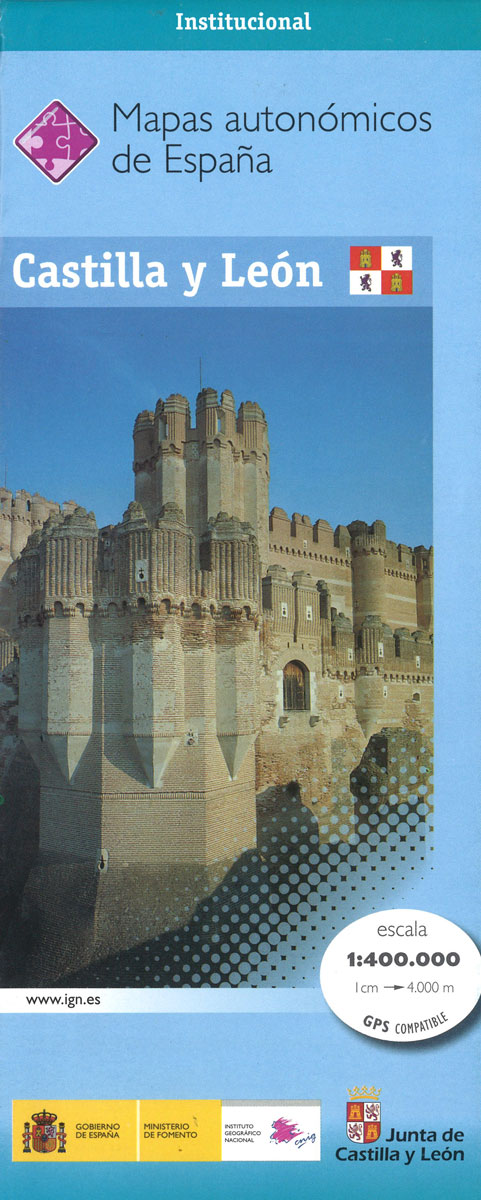
Castilla y Leon Autonomous Region of Spain at 1:400,000 in a series of physical road maps from CNIG – the country’s civilian survey organization, with an excellent presentation of the topography through relief shading and altitude colouring, plenty of names of mountain ranges, peaks, etcRelief shading is enhanced by bright altitude colouring, with plenty of names of mountain ranges, peaks, etc, plus additional spot heights. Boundaries of national and natural parks are marked. Topographic colouring does not continue beyond the region’s administrative boundary, although the road network and other information are included. The maps show the regional road network, from toll motorways to local country tracks, railways and local airports or aerodromes. Symbols highlight locations of paradors, ski areas, monasteries and other historical monuments, etc. On more recent edition this information is more prominently highlighted by small icons and includes campsites. The maps also show administrative boundaries of provinces within each region and town symbols indicate their administrative status and the number of inhabitants. The maps have a UTM grid, plus 1’ latitude and longitude margin ticks. Map legend is in Spanish onlyPLEASE NOTE: the maps are sold for their excellent presentation of the topography ‘“ the road network may not necessarily be up-to-date.To see other titles in this series please click on the series link.

Related Products:
 Castilla-La Mancha Autonomous Community CNIG Physical Road Map
Castilla-la-Mancha Autonomous Region 400K CNIG Physical Road Map
Castilla-La Mancha Autonomous Community CNIG Physical Road Map
Castilla-la-Mancha Autonomous Region 400K CNIG Physical Road Map
 Cantabria Autonomous Community CNIG Physical Road Map
Murcia Autonomous Region 200K CNIG Physical Road Map
Extremadura Auotomous Community CNIG Physical Road Map
Cantabria Autonomous Community CNIG Physical Road Map
Murcia Autonomous Region 200K CNIG Physical Road Map
Extremadura Auotomous Community CNIG Physical Road Map
 Andalusia Autonomous Community CNIG Physical Road Map
Spain: CNIG Road Maps of Autonomous Administrative Regions
Andalusia Autonomous Community CNIG Physical Road Map
Spain: CNIG Road Maps of Autonomous Administrative Regions
 Aragรณn Autonomous Region 300K CNIG Physical Road Map
 Catalonia Auotomous Community CNIG Physical Road Map
Canary Islands Autonomous Region 350K CNIG Physical Road Map
Catalonia Auotomous Community CNIG Physical Road Map
Canary Islands Autonomous Region 350K CNIG Physical Road Map
 Murcia Auotomous Community CNIG Physical Road Map
 Spain: CNIG 500K Regional Road Maps
Spain Autonomous Regions CNIG Wall Map
Spain: CNIG 500K Regional Road Maps
Spain Autonomous Regions CNIG Wall Map
 Tibet Gizi Road Map
 Nuevo Leon State
 Caucasus Road Edition Wall Map
 Catalonia Editorial Alpina Road Map
 Tibet Road Edition Wall Map
 Valencia Auotomous Community CNIG Physical Road Map
 Galicia Auotomous Community CNIG Physical Road Map
 Mongolia Gizi Road Map
 Central Asia (Road Edition)
 Yevreyska Autonomous Oblast Road Atlas
 Central Asia Road Edition Wall Map
 Castilla y Leon – Madrid Michelin Regional 575
 Libya Gizi Road Map
 Libya Road Edition Wall Map
 Mongolia Road Edition Wall Map
 Galicia: Santiago de Compostela – Leรณn 500K CNIG Regional Map No.1
 Australia Columbus Globes Political / Physical Wall Map
 Crimea Autonomous Republic
 France: IGN 150K Departmental Road Maps
 Madrid – Toledo – Zagaroza 500K CNIG Regional Map No. 6
 Extremadura: Badajoz – Toledo – Cรณrdoba 500K CNIG Regional Map No. 8
 Pyrenees East – Barcelona – Costa Brava 500K CNIG Regional Map No. 4
 Spain North 500K CNIG 2
 Great Lakes USA 03 Hallwag Road Map
 Barcelona – Zaragoza – Castellรณn de la Plana 500K CNIG Regional Map No. 7
 USA: Hallwag Regional Road Maps
 Deep South USA 10 Hallwag Road Map