Disclosure : This site contains affiliate links to products. We may receive a commission for purchases made through these links.
Carte de France 1804
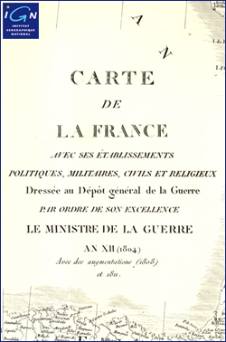
Historical map of France from 1804 printed on thick art card. It extends as far as southern England (to Oxford), the Netherlands, the Ruhr, Leipzig, Dresden, Venice and Tuscany. The legend at the foot of the map reads: “Carte de la France avec ses รฉtablissements politiques, militaires, civils et religieux. Dressรฉe au Dรฉpรดt gรฉnรฉral de la Guerre par ordre de son Excellence le Ministre de la Guerre an XII (1804). Avec des augmentations (1808) et 1811.”

Related Products:
 The Balkans, 1804-2012: Nationalism, War and the Great Powers
 SHOM Chart 6561 – Carte Conforme Oblique de l’Ocรฉan Atlantique Nord. France-Antilles – Route du Rhum
 SHOM Chart 6561L – Carte Conforme Oblique de l’Ocรฉan Atlantique Nord. France-Antilles – Route du Rhum – Leisure A4 size
 France : Waterway Routes Through France
 Wild Swimming France: Discover the Most Beautiful Rivers, Lakes and Waterfalls of France
 France IGN Wine Wall Map
 France: Didier Richard Hiking Maps of South Eastern France and Corsica
 Take the Slow Road: France: Inspirational Journeys Round France by Camper Van and Motorhome
 Let`s Eat France!: 1,250 Specialty Foods, 375 Iconic Recipes, 350 Topics, 260 Personalities, Plus Hundreds of Maps, Charts, Tricks, Tips, and Anecdotes and Everything Else You Want to Know about the Food of France
 France IGN Greenways and Cycle Routes Wall Map
 France Michelin Wall Map ENCAPSULATED
 Le Tour De France 2015
 France: IGN 100K Top100 Road Maps of France
 No More France Please
 The Complete Book of the Tour De France
 Retiring In France
 EuroVelo 6 – France East Cycling Guide
 France North K+F Road Map
 Tour De France – Climbs From Above
 France North Hallwag Road Map
 France South Hallwag Road Map
 France De Long Wine Map
 France South-East IGN Road Map 804
 Inland Waterways of France Map
 Butcher, Blacksmith, Acrobat, Sweep: The Tale of the First Tour de France
 France North-West IGN Road Map
 France Borch
 France: Inland Waterways Map
 France ITMB Rail & Road
France IGN RAISED RELIEF 60904
France ITMB Rail & Road
France IGN RAISED RELIEF 60904
 France IGN Road Map 2020 WATERPROOF
 France Hallwag Road Map
 France South-West IGN Road Map 2020
 Northern France Insight Travel Map
 Living and Working in France
France Map (c.1830) Wrap
Living and Working in France
France Map (c.1830) Wrap
 Watersteps Through France
France North Rail & Bike ITMB
Watersteps Through France
France North Rail & Bike ITMB
 France Hand Flag
 The Discovery of France: Picador Classic