Disclosure : This site contains affiliate links to products. We may receive a commission for purchases made through these links.
Carlisle South-East 1924
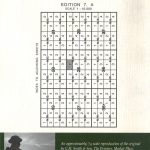
Carlisle South-East in 1924 in a fascinating series of reproductions of old Ordnance Survey plans in the Alan Godfrey Editions, ideal for anyone interested in the history of their neighbourhood or family. Carlisle is covered by four maps. This title covers the south-eastern area, stretching from Cecil Street eastward to Durranhill Park and southward to Millholme Avenue. Features include eastern end of Citadel station with railway approaches, numerous junctions including start of lines to Settle and Newcastle, LMSR engine shed and carriage shed, LNER engine shed, Petteril Bridge Goods Station, Durranhill Sidings, LMSR engine shed (for Settle line), Harraby, Harraby Green, Auction Mart, Albion Mills, Christ Church, Palace Theatre, tramways, Fusehill House Poor Law Institution, Botchergate area, St Nicholas Works, etc. On the reverse is a selection of street directory entries, including Lindisfarne Street, Petteril Terrace, Sybil Street and Thomson Street.About the Alan Godfrey Editions of the 25″ OS Series:Selected towns in Great Britain and Ireland are covered by maps showing the extent of urban development in the last decades of the 19th and early 20th century. The plans have been taken from the Ordnance Survey mapping and reprinted at about 15 inches to one mile (1:4,340). On the reverse most maps have historical notes and many also include extracts from contemporary directories. Most maps cover about one mile (1.6kms) north/south, one and a half miles (2.4kms) across; adjoining sheets can be combined to provide wider coverage.FOR MORE INFORMATION AND A COMPLETE LIST OF ALL AVAILABLE TITLES PLEASE CLICK ON THE SERIES LINK.

Related Products:
 Carlisle South-West 1924
Carlisle North-East 1924
Carlisle South-West 1924
Carlisle North-East 1924
 Manchester South-East 1915
Worcester South-East 1902
Leeds South and South East 1890 (Colour Edition)
Manchester South-East 1915
Worcester South-East 1902
Leeds South and South East 1890 (Colour Edition)
 Leeds South and South East 1906
Silloth and Port Carlisle 1923
Leeds South and South East 1906
Silloth and Port Carlisle 1923
 Workington South 1923
Glasgow East End 1893
Swindon South-East 1899
Workington South 1923
Glasgow East End 1893
Swindon South-East 1899
 Newquay East 1933
Colwyn Bay South East 1911
Bedford 1924 – 11.16b
Nottingham (South) 1899 – 42.06b
Barnsley South East 1904
Cirencester East 1920
Newquay East 1933
Colwyn Bay South East 1911
Bedford 1924 – 11.16b
Nottingham (South) 1899 – 42.06b
Barnsley South East 1904
Cirencester East 1920
 Northwich North East 1908
Ipswich South-West 1902
Northwich North East 1908
Ipswich South-West 1902
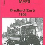 Bradford East 1906
 Watford South and New Bushey 1896
 Carlisle (NW) 1924 – 23.03
Doncaster South 1928 – 285.01b
Wakefield (South) 1890 – 248.07a
Gateshead East 1895
Whitehaven South 1923
Burton on Trent South 1900
Carlisle (NW) 1924 – 23.03
Doncaster South 1928 – 285.01b
Wakefield (South) 1890 – 248.07a
Gateshead East 1895
Whitehaven South 1923
Burton on Trent South 1900
 Hull North East 1908
Glasgow High Street 1909
Glasgow High Street 1933
Craigendoran and Helensburgh East 1897
Worcester North-East 1902
Hull North East 1908
Glasgow High Street 1909
Glasgow High Street 1933
Craigendoran and Helensburgh East 1897
Worcester North-East 1902
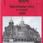 Manchester SE & Ardwick 1932 – 104.11b
 Sedgley South-East with Swan Village and West Coseley 1901
South East Essex 1884
Sedgley South-East with Swan Village and West Coseley 1901
South East Essex 1884
 Tredegar South 1899
Enfield (South) 1895 – 7.07a
Trafford Park South 1937
Tredegar South 1899
Enfield (South) 1895 – 7.07a
Trafford Park South 1937
 Walsall (SW) & Pleck 1901 – 63.10a
 Bootle 1907
 Settle to Carlisle Way