Disclosure : This site contains affiliate links to products. We may receive a commission for purchases made through these links.
Cap de Creus Park Natural Editorial Alpina
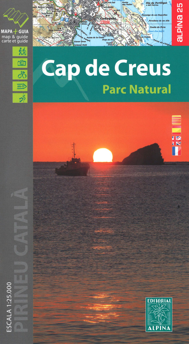
Cap de Creus Natural Park on the Costa Brava at 1:25,000 on a contoured and GPS compatible map from Editorial Alpina, plus a booklet which includes English language descriptions several recommended hiking trails, accommodation details, etc.Topography is presented by contours at10m intervals with relief shading and plenty of spot heights, plus colouring and/or graphics for different types of vegetation. An overprint highlights local and long-distance waymarked hiking trails and mountain bike routes. Symbols indicate different types of accommodation including campsites and youth hostels, sport and recreational facilities, interesting trees, etc. Road network shows locations of car parks and petrol stations. The map has a 1km UTM grid, plus latitude and longitude margin ticks at 1’ intervals. Map legend includes English.Accompanying booklet has 25 pages in English, providing descriptions of 12 recommended walks in the park plus four longer hikes, also contact details of local accommodation including campsites, descriptions of various places of interest, etc.To see the list of titles in this Editorial Alpina series which provides coverage of most popular hiking areas of Spain please click on the series link.

Related Products:
 Cabo de Gata-Nรญjar Natural Park Editorial Alpina
 Alt Pirineu Natural Park Editorial Alpina
 Posets-Maladeta Natural Park 2-Map Set Editorial Alpina
 Cavalls del Vent – Cadi-Moixero Natural Park Hiking Circuit Editorial Alpina
 Aigรผestortes and Estany de Sant Maurici National Park 2-Map Set Editorial Alpina
 Moixerรณ – La Tosa – Cadรญ-Moixerรณ Natural Park Editorial Alpina
 Ordesa and Monte Perdido National Park Editorial Alpina
 Montgrony – Fonts del Llogregat – Parc Natural del Cadรญ-Moixerรฒ Editorial Alpina
Ordesa – Monte Perdido National Park Editorial Alpina 2-Map Set
Montgrony – Fonts del Llogregat – Parc Natural del Cadรญ-Moixerรฒ Editorial Alpina
Ordesa – Monte Perdido National Park Editorial Alpina 2-Map Set
 Mallorca – Tramuntana Central Editorial Alpina
 Ordesa and Monte Perdido National Park 2-Map Set Editorial Alpina
 Mallorca – Tramuntana South Editorial Alpina
Collserola Parc Natural Editorial Alpina
Sierra Nevada – La Alpujarra Editorial Alpina
Mallorca – Tramuntana South Editorial Alpina
Collserola Parc Natural Editorial Alpina
Sierra Nevada – La Alpujarra Editorial Alpina
 Vall de Lord – Port del Comte Editorial Alpina
 Garrotxa – Zona Volcanica Editorial Alpina
 Mallorca – Tramuntana North Editorial Alpina
 Ibiza – Formentera Editorial Alpina
 Cotiella ‘“ Peรฑa Montaรฑesa Editorial Alpina
 Vall Fosca – Montsent de Pallars Editorial Alpina 2-Map Set
 Sierra de Gredos – Almanzor – Laguna Grande Editorial Alpina
 Sierra de Huetor Natural Park Editorial Penibetica SPANISH
 Muntanya d’Alinyร Editorial Alpina
Serra de Tramuntana Editorial Alpina 4-Map Set
Muntanya d’Alinyร Editorial Alpina
Serra de Tramuntana Editorial Alpina 4-Map Set
 Serra del Cadรญ – Pedraforca Editorial Alpina
 Sant Maurici Editorial Alpina
Cingles de Berti – Sant Miquel des Fai Editorial Alpina
Sant Maurici Editorial Alpina
Cingles de Berti – Sant Miquel des Fai Editorial Alpina
 Aneto – Maladeta – PN Posets Editorial Alpina
Sant Llorenc del Munt i l`Obac Editorial Alpina
Bachimala – Valles de Chistau y Bielsa Editorial Alpina
Aneto – Maladeta – PN Posets Editorial Alpina
Sant Llorenc del Munt i l`Obac Editorial Alpina
Bachimala – Valles de Chistau y Bielsa Editorial Alpina
 Costabona – Alta Val de Ter Editorial Alpina
 Ripollรจs Editorial Alpina
 Taga – Serra Cavallera Editorial Alpina
Valles de Ansรณ & Echo Editorial Alpina
Montnegre – Corredor Editorial Alpina
Vall de Boรญ – Aigรผestortes PN Editorial Alpina
Taga – Serra Cavallera Editorial Alpina
Valles de Ansรณ & Echo Editorial Alpina
Montnegre – Corredor Editorial Alpina
Vall de Boรญ – Aigรผestortes PN Editorial Alpina
 Puigmal – Vall de Nuria – Ulldeter Editorial Alpina
Puigsacalm – Bellmunt Editorial Alpina
Puigmal – Vall de Nuria – Ulldeter Editorial Alpina
Puigsacalm – Bellmunt Editorial Alpina
 Delta of the Ebro ‘“ Serra de Montsiร Editorial Alpina
 Carros de Foc Hiking Circuit Editorial Alpina