Disclosure : This site contains affiliate links to products. We may receive a commission for purchases made through these links.
Canada MapArt
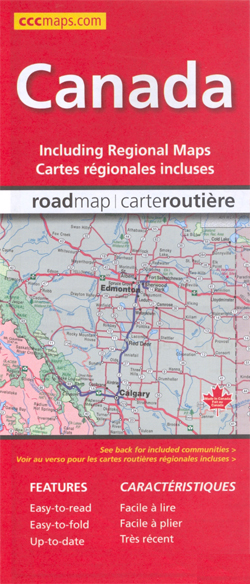
Canada at 1:6,000,000 on a double-sided map from the Canadian Cartographics Corporation combining an overview map of the country with, on the reverse, more detailed mapping of its more densely populated regions.On one side is an overview map of the whole country at 1:6,000,000 extending north beyond 75ยบ of latitude to include the southern part of Ellesmere Island. Each province is presented in different colour. The map shows the road network, highlighting Trans-Canada Highway. Railway lines are not included. Numerous rivers and lakes provide topographic information, with national or provincial parks and forests highlighted. The map has latitude and longitude lines at 5ยบ intervals and also shows time zone boundaries.On the reverse the more densely populated areas are shows on separate panels with their road networks presented in greater details:* Southern Quรฉbec around Montrรฉal and Quรฉbec City at 1:1,250,000* Ontario from Ottawa to Windsor and Detroit at 1:1,000,000* Southern New Brunswick with central Nova Scotia at 1:900,000* Southern Manitoba, Saskatchewan from Regina to Saskatoon, and Alberta around Calgary and Edmonton, each at 1:1,875.000* Southern British Columbia from Vancouver Island to the Kootenay Lake at 1:1,875,000Also provided is a comprehensive distance table.*Please note:* following a number changes among Canadian cartographic publishers maps previously published by MapArt Publishing may now be available under one of the following imprints: MapArt, Canadian Cartographics Corporation or JDM Gรฉo Inc. Within a series, therefore, some titles may still be published as MapArt whilst others will be available as Canadian Cartographics Corporation or JDM Gรฉo Inc.

Related Products:
 Canada MapArt Road Atlas
 Western Canada MapArt
 Canada: MapArt / Canadian Cartographics Corporation Provincial and Regional Road Maps and Atlases
Canada: MapArt/Canadian Cartographics Corporation Cities and Regions Street Maps and Road Atlases
Canada: MapArt / Canadian Cartographics Corporation Provincial and Regional Road Maps and Atlases
Canada: MapArt/Canadian Cartographics Corporation Cities and Regions Street Maps and Road Atlases
 Canada FastTrack
 Vancouver Island MapArt Street Atlas
 Canada – USA – Mexico Road Atlas
 Quebec MapArt Street Plan
 Toronto & Area MapArt Street Atlas
Ontario MapArt
Toronto & Area MapArt Street Atlas
Ontario MapArt
 Manitoba & Saskatchewan MapArt Road Atlas
 Greater Victoria BC MapArt
 Quรฉbec Province MapArt
Vancouver Island – Sunshine Coast – Gulf Islands BC MapArt
Quรฉbec Province MapArt
Vancouver Island – Sunshine Coast – Gulf Islands BC MapArt
 Ottawa MapArt Street Plan
 Ontario Eastern MapArt
 Vancouver & Area MapArt Street Plan
 British Columbia – Alberta MapArt
 Saskatchewan MapArt
 Toronto MapArt Street Plan
 New Brunswick MapArt
 Ontario MapArt Back Road Atlas
 Cape Breton Island – Sydney – Truro NS MapArt
 Atlantic Canada – New Brunswick – Nova Scotia – Prince Edward Island – Newfoundland
 Montreal MapArt Street Plan
 Halifax – Dartmouth & Area MapArt
 Ontario MapArt Pocket Road Atlas
 Nova Scotia MapArt
 Niagara Region (Canada) FastTrack Map
 Manitoba MapArt
 Alberta MapArt
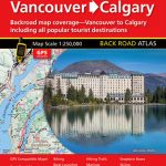 Vancouver to Calgary MapArt Back Road Atlas
 Ontario South Central – Toronto – Niagara Falls – Kitchener-Wateroo Mapart Back Road Map
 Calgary & Southern Alberta Street Atlas
 Winnipeg Pocket Street Atlas
 Winnipeg and Area Street Atlas
 Alberta MapArt Back Road Atlas
 Niagara Falls – Fort Erie – Niagara-on-the-Lake – Grand Island
 British Columbia MapArt
 Maritimes Provinces: New Brunswick – Nova Scotia – Prince Edward Island MapArt Back Road Atlas