Disclosure : This site contains affiliate links to products. We may receive a commission for purchases made through these links.
Cambodia – Angkor Nelles
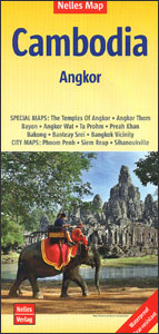
Cambodia at 1:1,500,000 from Nelles Verlag, with its smaller size map offering a convenient format for use when travelling and now published on light, waterproof and tear-resistant synthetic paper. The whole of the reverse side provides detailed plans and descriptions of the Angkor World Heritage site. Coverage includes Bangkok and the southern part of Vietnam. On one side is a road map of the country accompanied by street plans of Phnom Penh, Sihanoukville and Siem Reap. Vivid relief shading with spot heights and names of mountain ranges presents the topography. National parks and/or protected area are indicated. Road network indicates partially paved roads and cart tracks, and shows distances on main routes. Railway lines and local airports are included and the map also shows internal administrative boundaries with names of the provinces. Numerous places of interest are prominently marked, both in Cambodia and in the adjoining areas of the neighbouring countries. Latitude and longitude margin ticks are at 1ยฐ intervals. The map has no index of localities. In addition to the three street plans, all annotated with places of interest and various facilities, also included is an enlargement of the Bangkok area. The whole of the reverse side is devoted to maps and plans of the World Heritage site at Angkor. A detailed map of the Siem Reap area shows road access to the site and numerous other temples and archaeological remains. Seven plans, accompanied by informative descriptions, present Angkor Wat, Bayon and other temples indicating names of various shrines, halls, etc. Map legend is in English, German and French – all the descriptive text is in English only.

Related Products:
 Cambodia Periplus Travel Map
 Cambodia Reise Know-How
 Angkor Gecko Panorama Map
 Lonely Planet Pocket Siem Reap & the Temples of Angkor
 Cambodia Gecko Map
 Vietnam – Laos – Cambodia Nelles
 Angkor Wat Footprint Handbook
 Moon Angkor Wat Handbook
 Thailand, Vietnam, Laos & Cambodia ITMB Travel Atlas
The Story of Angkor
Thailand, Vietnam, Laos & Cambodia ITMB Travel Atlas
The Story of Angkor
 Tunisia Nelles Map
 Myanmar / Burma Nelles
 Cambodia – the Khmer Legacy Odyssey Illustrated Map
 Bolivia – Paraguay Nelles
 Thailand Nelles
 Presenting Cambodia
 DK Eyewitness Travel Guide Cambodia and Laos
 Malaysia – Brunei Nelles
 Angkor Sketches of an Ancient City
 Malaysia West – Singapore Nelles
 Bangkok and Greater Bangkok Nelles
 Java – Jakarta Nelles
 Cuba Nelles
Taiwan Nelles
Cuba Nelles
Taiwan Nelles
 Bali – Lombok Nelles
 Hawaii – The Big Island Nelles
 Hawaii – Maui – Molokai – Lanai Nelles
 New Zealand Nelles
 India South Nelles
 Central America Nelles
 Colombia – Ecuador Nelles
 Hong Kong Nelles
Kenya – Serengeti Nelles
Hong Kong Nelles
Kenya – Serengeti Nelles
 Central Asia Nelles
 Enchanting Cambodia (2nd edition)
 Bangkok Borch
 Mexico Nelles
 Peru – Ecuador Nelles
 Hawaii – Oahu – Honolulu Nelles
 Argentina North – Uruguay Nelles