Disclosure : This site contains affiliate links to products. We may receive a commission for purchases made through these links.
Cairns and Region Hema
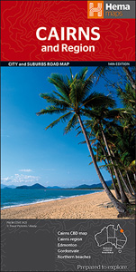
Cairns and Region in a series of maps from Hema presenting Australia’s main cities with three maps: a detailed street plan of the central area, a road map of the city with its outer suburbs, plus a map of the wider surrounding region for out-of-town excursions. The Cairns map contains:- A small street plan of Cairn’s town centre between the city’s railway station and the Cruise Liner Terminal and the Marina.- Three separate panels providing continuous coverage with indexed suburban maps at 1:22,500 from Palm Cove on the Northern Beaches, across Cairns, to Edmonton. Plus a similar mapping of the Gordonvale area further south. All four are indexed. – A regional map at approx 1:625,000 covering the coastline south to Wongaling Beach and north to beyond Mossman, plus inland to Mount Garnet in the Atherton Tableland. The map shows the road network indicating unsurfaced roads and tracks. Symbols mark roadside rest areas, campsites, various places of interest, etc. Topography is indicates by names of mountain ranges and selected peaks, plus rivers and lakes; national and state parks, conservation areas and reserves are all highlighted.To see other titles in this series please click on the series link.

Related Products:
 Canberra and Region Hema
 Sydney and Region Hema
 Perth and Region Hema
 Adelaide and Region Hema
 Melbourne and Region Hema
 Brisbane to Cairns Hema
Gold Coast and Region Hema
Brisbane to Cairns Hema
Gold Coast and Region Hema
 Savannah Way – Cairns to Broome Hema Touring Map
 Brisbane Hema
Australia: Hema Maps of Main Cities and Surrounding Regions
Brisbane Hema
Australia: Hema Maps of Main Cities and Surrounding Regions
 South Australia Hema
 Victoria Hema
 Argentina ACA Regional Zone 5 – Region Cuyo (incl. Aconcagua – Mendoza – San Luรญs)
 Australia: Hema State Road Maps
 Queensland Hema
 Kiev Administrative Region
Zaporizhzhia Administrative Region
Zhytomyr Administrative Region
Ternopil Administrative Region
Khmelnytskyi Administrative Region
Lviv Administrative Region
Dnipropetrovsk Administrative Region
Mikolayiv Administrative Region
Rivne Administrative Region
Vinnytsia Administrative Region
Chernihiv Administrative Region
Kharkiv Administrative Region
Cherkasy Administrative Region
Poltava Administrative Region
Kirovohrad Administrative Region
Kherson Administrative Region
Chernivtsi Administrative Region
Sumy Administrative Region
Volynska Oblast Administrative Region
Kiev Administrative Region
Zaporizhzhia Administrative Region
Zhytomyr Administrative Region
Ternopil Administrative Region
Khmelnytskyi Administrative Region
Lviv Administrative Region
Dnipropetrovsk Administrative Region
Mikolayiv Administrative Region
Rivne Administrative Region
Vinnytsia Administrative Region
Chernihiv Administrative Region
Kharkiv Administrative Region
Cherkasy Administrative Region
Poltava Administrative Region
Kirovohrad Administrative Region
Kherson Administrative Region
Chernivtsi Administrative Region
Sumy Administrative Region
Volynska Oblast Administrative Region
 Zakarpatska Oblast Administrative Region
Ivano-Frankivsk Administrative Region
Zakarpatska Oblast Administrative Region
Ivano-Frankivsk Administrative Region
 Northern Territory Hema
 Argentina ACA Regional Zone 2 – Region Cuyo y Norte
 Argentina ACA Regional Zone 6 – Region Buenos Aires