Disclosure : This site contains affiliate links to products. We may receive a commission for purchases made through these links.
Bulgaria Road Atlas
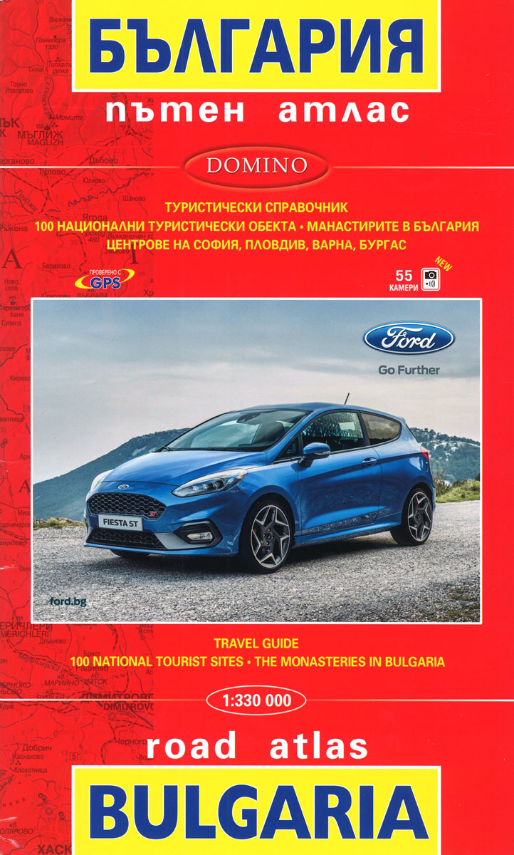
Road Atlas of Bulgaria at 1:330,000 from Domino with street plans of central Sofia, Plovdiv, Varna and Burgas, enlargements for the Black Sea coast holiday areas, plus lists of 100 best tourist sights and 169 monasteries.The atlas provides an excellent picture of the country’s topography with bright altitude colouring enhanced by relief shading and spot heights. National parks and other protected areas are highlighted. Road network is divided into seven grades, with driving distances shown on all routes except dirt tracks. Border crossings and services on main roads are marked. The atlas also shows railway lines. Interesting towns and village are prominently highlighted, as are important cultural monuments and natural sites. Symbols indicate other places of interest including campsites, churches and monasteries, etc. Names of larger towns are given in both Latin alphabet and Cyrillic, smaller settlements and geographical features are only in Cyrillic. The maps have no geographical coordinates. Map legend includes English.Extensive index is in Cyrillic only but includes English language lists of the country’s 100m best sights with, where appropriate, phone numbers, plus 169 monasteries indicating when they were built or renovated and annotated with dates of their patron saint celebrations. The index also has an extensive list of car dealers arranged by car make, but with all text except website addresses in Cyrillic only.Enlargement at 1:75,000 and 1:100,000 show in greater detail the Black Sea coast around the main holiday resorts. Also provided is a distance table, plus city centre street plans of Sofia, Plovdiv, Varna and Burgas, with tram/bus/trolleybus routes, one way streets and car parks, selected house numbers for easier identification of addresses, hotels, etc. All street names are in Cyrillic only.

Related Products:
 Bulgaria Pocket Road Atlas
 Bulgaria Domino DOUBLE-SIDED Road Map
 Bulgaria – City Centres Domino Road Map
 Bulgaria Cartographia Road Map
 Finland Road Atlas GLOVEBOX, SPIRAL-BOUND
 Bulgaria (with Street Plans of Black Sea Resorts)
 Latvia Jana Seta Compact Road Atlas
 Europe F&B Compact Road Atlas
 India Road Atlas
 Ukraine Kartografija Road Atlas 500K HARDBACK
 Ukraine Road Atlas (500K, Spiral-bound)
New Zealand Kiwimaps Travellers Road Atlas
Ukraine Road Atlas (500K, Spiral-bound)
New Zealand Kiwimaps Travellers Road Atlas
 Croatia – Slovenia F&B Road Atlas
Italy F&B Great Road Atlas SPIRAL-BOUND
Croatia – Slovenia F&B Road Atlas
Italy F&B Great Road Atlas SPIRAL-BOUND
 Sofia Street Atlas with Vitosha Massif
 Latvia Jana Seta Road Atlas
 Bulgaria (with Mountain Resorts)
 Lithuania Jana Seta Compact Road Atlas
 Austria – Liechtenstein – South Tyrol Marco Polo Road Atlas
 Italy Road Atlas A4 PAPERBACK
 Hungary – Budapest Road Atlas SPIRAL-BOUND
Spain Road Atlas 2021 Set (incl. Map and DVD)
Hungary – Budapest Road Atlas SPIRAL-BOUND
Spain Road Atlas 2021 Set (incl. Map and DVD)
 Alps – Northern Italy MairDumont Road Atlas SPIRAL-BOUND
Belarus Road Atlas
Italy TCI Road Atlas
Alps – Northern Italy MairDumont Road Atlas SPIRAL-BOUND
Belarus Road Atlas
Italy TCI Road Atlas
 Bulgaria (with Fishing Lakes)
 Norway Cappelens Road Atlas A4 SPIRAL-BOUND
 Finland Karttakeskus Motorbikers Road Atlas A5 SPIRAL-BOUND
 Carpathian Mountains Road Atlas
 Norway F&B Supertouring Road Atlas SPIRAL-BOUND
 Manitoba & Saskatchewan MapArt Road Atlas
 Belgium – Netherlands – Luxembourg Marco Polo Road Atlas
 Lithuania Jana Seta Road Atlas HARDBACK
Poland: Carta Blanca/Kompas Road Atlas 2015 GLOVEBOX, SPIRAL-BOUND
Lithuania Jana Seta Road Atlas HARDBACK
Poland: Carta Blanca/Kompas Road Atlas 2015 GLOVEBOX, SPIRAL-BOUND
 Netherlands Falk Maxi Road Atlas A4 SPIRALBOUND
Netherlands Falkplan Routiq Road Atlas
Netherlands Falk Maxi Road Atlas A4 SPIRALBOUND
Netherlands Falkplan Routiq Road Atlas
 Czech Republic Marco Polo Road Atlas
Poland ExpressMap Road Atlas 2020/2021
Czech Republic Marco Polo Road Atlas
Poland ExpressMap Road Atlas 2020/2021
 Crimea Road Atlas
 Skopje Street Atlas