Disclosure : This site contains affiliate links to products. We may receive a commission for purchases made through these links.
Budapest Flexi Map
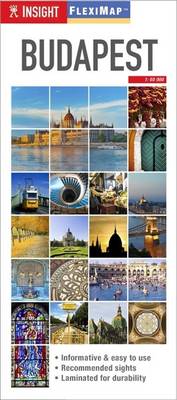
Central Budapest on an Insight Flexi Map in their new format introduced to provide more convenient access to the special features of this series: various additional maps and/or street plans plus tourist information including a list of must-see sights. The map is tear-resistant, waterproof, and can be written on with non-permanent marker pens.On one side is a street plan showing the city’s central districts. Coverage extends, roughly, between the Margit and the Petofi bridges across the Danube, and from the Dรฉli railway station on the Buda side to the Vรกrosliget park and the Puskรกs football stadium. A separate inset extends the plan further north to cover the whole of the Margit (Margaret) Island and the adjoining Buda side of the river.On the reverse are this title’s additional features: – A map of Budapest’s metro lines.- A road map at 1:350,000 of the environs of Budapest, including the Buda Hills, Szentendre and the Danube Bend with Esztergom.- Extensive index for the maps of the city and of the environs.- Brief descriptions of 24 main sights, neatly grouped into sections covering Major Attractions in Buda and in Pest, Shopping and Markets, plus Further Afield – all prominently highlighted on the street plan and/or the road map of the environs.- Information about Getting Around and Facts for Visitors, including tourist offices, public holidays, opening times, money, tipping, health, telecommunications and monthly climate charts.To see the list of other Insight Flexi titles in this series please click on the series link.

Related Products:
 Budapest Borch
 Hungary & Budapest ITMB
 Budapest Marco Polo City Map
 Budapest City Plan
 Budapest F&B City Pocket Map
 Kuala Lumpur Flexi Map
 Budapest F&B
 Barcelona Flexi Map
 Budapest Classic Plan
 Budapest Comfort Plan
 Budapest Cartographia EXTRA Plan
 Montreal Flexi Map OUT OF PRINT
 Amsterdam Flexi Map
 The Rough Guide to Budapest
 Turkey Flexi Map
 The Danube Cycleway: From Budapest to the Black Sea: Volume 2
 Linz F&B Tourist Street Plan
 Moon Budapest & Beyond – First Edition: Day Trips, Local Spots, Strategies to Avoid Crowds
 Insight Guides Pocket Budapest (Travel Guide with Free eBook)
 Danube Cycle Route Part 3: Vienna – Bratislava – Budapest (334km) Bikeline Map/Guide ENGLISH Ed.
 New Orleans
 Danube Cycle Route Part 4: Budapest – Belgrade (570km) Bikeline Map/Guide ENGLISH Ed.
 Macau Flexi Map
 Washington DC Borch
 Madrid Borch
 Salzburg F&B Tourist Street Plan
 Budapest & the Danube Bend (Pilis – Visegrรกd) Atlas
 Lisbon Borch
 Frankfurt am Main Borch
 Stockholm Borch
 Montreal
 EuroVelo 6 – Danube Bike Trail – Budapest to the Black Sea 8-Map Set
 DK Eyewitness Top 10 Budapest
 Budapest Michelin Green Guide Short Stays
 Rome Borch
 Budapest PopOut
 Kaliningrad Street Plan
 Rick Steves Budapest (Sixth Edition)
 Budapest Michelin Citymap
 Beijing Borch