Disclosure : This site contains affiliate links to products. We may receive a commission for purchases made through these links.
Budapest City Plan
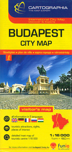
Budapest at 1:16,000 from Cartographia on an indexed plan covering the centre with the surrounding districts, plus an enlargement presenting the centre in greater detail, plus public transport diagrams including night bus services.On one side the plan at 1:16,000 covers the city from the Buda Hills to the Hungexpo grounds, and north/south from the Hajรณgyรกri Island to the Rรกkรณczi Bridge. Bus, tram and trolleybus routes are shown with line numbers; metro stations indicate numbers of the lines stopping there. Also marked and ferry services on the Danube. For drivers the map indicates main traffic arteries, one way or pedestrianized streets, and locations of car parks. Street index is on the reverse and includes a list of important sight, museums, bath and swimming pools, etc. Map legend includes English.Also on the reverse, the city centre on both sides of the Danube is presented in greater detail at 1:10,000, plus two diagrams showing the city’s metro/tram/suburban rail lines plus night services.

Related Products:
 Warsaw Marco Polo City Map
 Budapest Classic Plan
 Budapest Comfort Plan
 Budapest Cartographia EXTRA Plan
 Budapest Marco Polo City Map
 Basel Pocket Street Plan
 Tallinn Public Transport Map
 Riga City Center Jana Seta Street Plan
 Jurmala Jana Seta Street Plan
 Helsinki City Map
 Kaunas Jana Seta Street Plan
 Sofia Domino Street Plan
 Vienna F&B Tourist Street Plan
 Helsinki City Map & Guide
 Budapest Borch
 Hungary & Budapest ITMB
 Budapest Pocket Atlas
 Bratislava Street Plan
 Bishkek Street Plan
 Santiago de Chile Trekkingchile Street Plan
 Prague Borch
 Prague Marco Polo City Map
 Kharkov Kartografija Street Plan
 Vilnius Jana Seta Street Plan WATERPROOF
 Warsaw – Lomianki – Zabki ExpressMap Street Plan
 Iasi Cartographia Street Plan
 Bucharest F&B City Pocket Map
 Palma de Mallorca City Map / Mallorca Road Map
 St Petersburg Marco Polo City Map
 Budapest F&B City Pocket Map
 Nuremberg City Pocket Plan
 Geneva: Greater Geneva Street Plan
 Amsterdam Michelin Citymap
 Kaunas Jana Seta Street Plan WATERPROOF
Palermo TCI Street Plan
Kaunas Jana Seta Street Plan WATERPROOF
Palermo TCI Street Plan
 Constanta Cartographia Street Plan
 Kiev Kartografija Street Plan
 Tallinn Jana Seta Street Plan WATERPROOF
 Lviv ExpressMap Street Plan
 Trujillo Metro Plan