Disclosure : This site contains affiliate links to products. We may receive a commission for purchases made through these links.
Bryce Canyon & Brian Head UT Trail Map
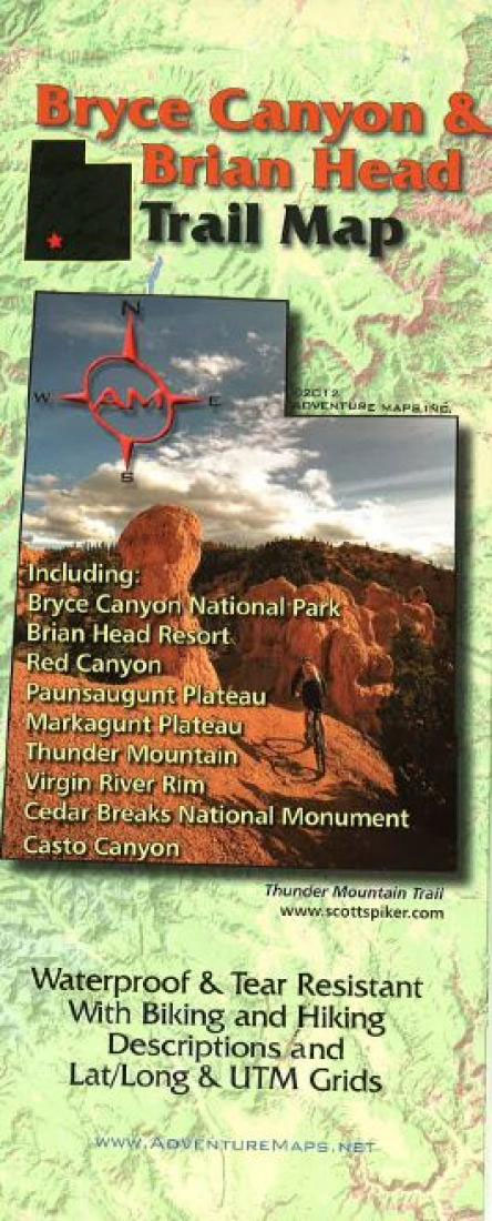
Bryce Canyon and Brian Head Trail in south-western Utah on a double-sided, waterproof and tear-resistant recreational map at 1:63,360 from Adventure Maps, contoured, GPS compatible, highlighting hiking, mountain biking, horse-riding and ATV/OHV trails, campsites, etc.The map is double-sided, covering an area from Cedar City in the west to Tropic and Cannonville east of the Bryce Canyon National Park. Topography is vividly presented by contours at 100 feet intervals, enhanced by relief shading. Numerous trails are highlighted and annotated with mileage; mountain bike trails also indicate the degree of technical difficulty. Eight recommended hiking trails and 18 mountain bike rides are cross-referenced to brief descriptions. Symbols indicate various facilities including campsites and campgrounds, visitors’ centres, picnic areas, etc. The map has both a UTM grid and latitude/longitude lines. Five additional panels present in greater detail the most popular areas such as the Brian Head Peak, Red Canyon and the Bryce Amphitheatre. The map also includes general information about the area, climate charts, etc.

Related Products:
 Bryce Canyon National Park UT
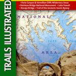
 Paunsaugunt Plateau – Mount Dutton – Bryce Canyon UT NGS Trails Illustrated Map 705
 Zion & Bryce Canyon National Parks Lonely Planet Planning Map
 Moon Utah (Thirteenth Edition): With Zion, Bryce Canyon, Arches, Capitol Reef & Canyonlands National Parks
 Lonely Planet Zion & Bryce Canyon National Parks
 Moon Utah (Fourteenth Edition): With Zion, Bryce Canyon, Arches, Capitol Reef & Canyonlands National Parks
 Fodor`s Utah: with Zion, Bryce Canyon, Arches, Capitol Reef & Canyonlands National Parks
 Moon Southwest Road Trip (Second Edition): Las Vegas, Zion & Bryce, Monument Valley, Santa Fe & Taos, and the Grand Canyon
 Moon Zion & Bryce: Including Arches, Canyonlands, Capitol Reef, Grand Staircase-Escalante & Moab
 Grand Canyon National Park East AZ
 Grand Canyon National Park West AZ
 Grand Canyon North and South Rims – Grand Canyon National Park AZ NGS Trails Illustrated Map 261
 Colca Canyon – Cotahuasi Canyon
 Black Canyon of the Gunnison NP CO
 Sequoia – Kings Canyon National Parks CA
 Glen Canyon NRA – Capitol Reef NP UT/AZ
 Salt River Canyon – Tonto National Forest AZ
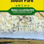 Elevenmile Canyon – South Park CO
 Sycamore Canyon – Verde Valley – Coconino, Kaibab and Prescott National Forests AZ
 Moon Grand Canyon
 Grand Canyon: The Complete Guide: Grand Canyon National Park
 Moon Zion & Bryce (Eighth Edition): With Arches, Canyonlands, Capitol Reef, Grand Staircase-Escalante & Moab
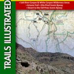
 Paria Canyon – Kanab – Vermillion Cliffs NM – Grand Staircase-Escalante NM AZ/UT
 Tower – Canyon – Yellowstone National Park WY/MT
 Moon Best of Zion & Bryce (First Edition): Make the Most of One to Three Days in the Parks
 Fish River Canyon
 Grand Canyon & Arizona ITMB
 EuroVelo 6 – Danube Bike Trail – Budapest to the Black Sea 8-Map Set
 Withernsea & Spurn Head OS Explorer Map 292 (paper)
 Withernsea & Spurn Head OS Explorer Active Map 292 (waterproof)
 Scarborough, Bridlington & Flamborough Head OS Explorer Map 301 (paper)
 Canyon Wilderness of The Southwest
 Salt Lake City – Park City and the Wasatch Trail Map
 Grand Canyon
 Tatev & the Vorotan Canyon Cartisan Hiking Map
 Thurso & John o`Groats – Dunnet Head OS Explorer Map 451 (paper)
 A Duck Called Brian (PB)
 Scarborough, Bridlington & Flamborough Head OS Explorer Active Map 301 (waterproof)
 St. George – Hurricane & Zion NP UT Trail Map & Guide
 Berwick-upon-Tweed – Eyemouth, Duns, St Abb`s Head & Cockburnspath OS Explorer Map 346 (paper)