Disclosure : This site contains affiliate links to products. We may receive a commission for purchases made through these links.
Brussels Marco Polo City Map
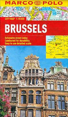
Brussels on a waterproof and tear-resistant street plan at 1:15,000 from Marco Polo Travel Publishing with a diagram of the city’s metro/tram/rail network, a road map of the environs, and an index with lists of places of interest, etc.Coverage extends north just beyond the Atomium and the nearby trade fair grounds, west to take in the NATO headquarters, south to the hippodrome in Forรชt de Soignes / Zoniรซnwoud, and eastwards to Andrelecht stadium. Metro stations are prominently marked and along the streets tram and bus routes are shown with stops and line numbers. For drivers the plan highlights principal traffic routes and shows one way streets, entry restrictions and car parks. Important buildings are highlighted and named. Place names are given and indexed in both in their French and Dutch versions. Street index on the reverse side includes separate lists and where appropriate contact details of various places of interest and facilities, such as public transport offices, accommodation agencies, car hire, museums, etc.Also provided is a diagram of the city’s combined metro, tram and rail network, plus a road map of the environs including Leuven and Waterloo. Cartography in this title is from the renowned German map publishers MairDumont and the multilingual map legend includes English.

Related Products:
 Hong Kong Marco Polo City Map
 Warsaw Marco Polo City Map
 Prague Marco Polo City Map
 Budapest Marco Polo City Map
 Rio de Janeiro Marco Polo City Map
 Bangkok Marco Polo City Map
 Cape Town Marco Polo City Map
 Istanbul Marco Polo City Map
 St Petersburg Marco Polo City Map
 Berlin Marco Polo City Map
 Florence Marco Polo City Map
 Helsinki City Map
 Boston Marco Polo City Map
 Frankfurt Marco Polo City Map
 Innsbruck City Map
 Munich Marco Polo City Map
 Stockholm Borch
 Hamburg Marco Polo City Map
 Palma de Mallorca City Map / Mallorca Road Map
 Helsinki & Southern Finland ITMB
 Helsinki City Map & Guide
 Barcelona Borch
 Rome NGS City Destinations Map
 Kharkov Kartografija Street Plan
 Brussels Borch
 Riga ITMB
 Istanbul & Northwest Turkey ITMB
 Nuremberg City Pocket Plan
 Zurich & Switzerland NW ITMB
 Osaka & Western Japan ITMB
 Linz F&B Tourist Street Plan
 Porto Michelin City Plan and Index
 Riga City Center Jana Seta Street Plan
 Geneva & Switzerland ITMB
 Budapest F&B
 Prague Borch
 Moscow Jana Seta Street Plan
 Brussels F&B City Pocket Map
 Rome
Rome
 Brussels Hike & Bike Map