Disclosure : This site contains affiliate links to products. We may receive a commission for purchases made through these links.
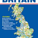
Britain Collins Road Map 2023
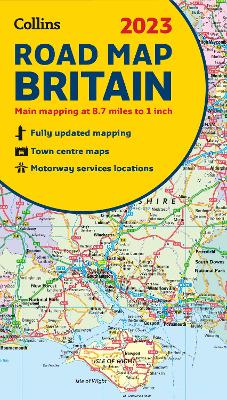
Full colour double-sided map of Great Britain at 8.7 miles to 1 inch (1:550,000), with clear, detailed road network and administrative areas shown in colour.With its political colouring of counties and unitary authorities it is ideal for business users but it is also perfect for tourists as a route planning map.Main features* Fully updated* Counties and local council areas shown in colour* Clear, detailed road network* Town and city names, rivers, railway lines and canals are clearly shown* 16 city/town centre street plans* Index to place names* Mileage chart* Car ferry routes* Key in English, French and GermanArea of coverageDouble-sided road map covering the whole of Britain. Northern England, Scotland and the Isle of Man are on one side with Southern England and Wales on the other.

Related Products:
 Ireland Collins Road Map 2023
Scotland Collins Road Map 2023
Ireland Collins Road Map 2023
Scotland Collins Road Map 2023
 Ireland Collins Road Map 2021
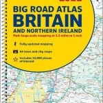
Britain and Northern Ireland Collins Big Road Atlas 2023 A3 PAPERBACK
Britain and Northern Ireland Collins Big Road Atlas 2023 A3 SPIRAL-BOUND
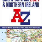
Great Britain & Northern Ireland A-Z Road Atlas 2023 A3 PAPERBACK
Great Britain A-Z Handy Road Atlas 2023 A5 SPIRAL-BOUND
Britain and Ireland Collins Handy Road Atlas 2023 A5 SPIRAL-BOUND
Ireland Collins Road Map 2021
Britain and Northern Ireland Collins Big Road Atlas 2023 A3 PAPERBACK
Britain and Northern Ireland Collins Big Road Atlas 2023 A3 SPIRAL-BOUND
Great Britain & Northern Ireland A-Z Road Atlas 2023 A3 PAPERBACK
Great Britain A-Z Handy Road Atlas 2023 A5 SPIRAL-BOUND
Britain and Ireland Collins Handy Road Atlas 2023 A5 SPIRAL-BOUND
 Britain and Northern Ireland Collins Big Road Atlas 2021 A3 PAPERBACK
 Britain and Northern Ireland Collins Big Road Atlas 2022 A3 PAPERBACK
Great Britain A-Z Road Atlas 2023 A4 SPIRAL-BOUND
Britain and Northern Ireland Collins Big Road Atlas 2022 A3 PAPERBACK
Great Britain A-Z Road Atlas 2023 A4 SPIRAL-BOUND
 Britain and Northern Ireland Collins Essential Road Atlas 2021
Britain and Northern Ireland Collins Essential Road Atlas 2022 A4 SPIRAL-BOUND
Britain and Northern Ireland Collins Essential Road Atlas 2021
Britain and Northern Ireland Collins Essential Road Atlas 2022 A4 SPIRAL-BOUND
 Britain and Northern Ireland Collins Big Road Atlas 2022 A3 SPIRAL-BOUND
Great Britain & Northern Ireland A-Z Super Scale Road Atlas 2023 A3 SPIRAL-BOUND
Britain and Northern Ireland Collins Big Road Atlas 2022 A3 SPIRAL-BOUND
Great Britain & Northern Ireland A-Z Super Scale Road Atlas 2023 A3 SPIRAL-BOUND
 Great Britain A-Z Road Atlas 2022 A4 SPIRAL-BOUND
 Great Britain & Northern Ireland A-Z Road Atlas 2022 A3 PAPERBACK
 Britain Philip`s Big Easy to Read Road Atlas 2022 A3 SPIRAL-BOUND
 Great Britain & Northern Ireland A-Z Road Atlas 2021 A3 PAPERBACK
 Great Britain A-Z REVERSIBLE Road Map
 Great Britain: AA Regional Road Maps
 Britain and Ireland Philip`s Road Atlas 2022 A4 PAPERBACK
 Great Britain A-Z Road Map
 Britain & Ireland Philip`s Essential Road Atlas 2021 A4 PAPERBACK
 Britain and Ireland Collins Handy Road Atlas 2022 A5 SPIRAL-BOUND
 Britain & Ireland Philip`s Road Atlas 2022 A4 SPIRAL-BOUND
 Great Britain & Northern Ireland A-Z Super Scale Road Atlas 2022 A3 SPIRAL-BOUND
 Great Britain A-Z Handy Road Atlas 2021
 Britain and Ireland Collins Handy Road Atlas 2021 A5 SPIRAL-BOUND
 Great Britain A-Z Handy Road Atlas 2022 A5 SPIRAL-BOUND
 Ireland Collins Handy Road Atlas
 Britain & Ireland Philip`s Complete Road Atlas 2020 SPIRAL-BOUND
 Britain & Ireland Philip`s Big Road Atlas 2021 A3 PAPERBACK
 Britain & Ireland Philip`s Motorist`s Road Atlas 2019 A3 PAPERBACK
 Britain & Ireland Philip`s Complete Road Atlas 2020 HARDBACK
 Jamaica Collins Road Map
 Britain Philip`s Easy to Read Road Atlas 2022 A4 PAPERBACK
 Britain & Ireland Philip`s Big Road Atlas 2022 A3 PAPERBACK
 France Collins Road Map 2021
 Britain & Ireland Philip`s Big Road Atlas 2022 A3 SPRIAL-BOUND