Disclosure : This site contains affiliate links to products. We may receive a commission for purchases made through these links.
Britain and Ireland Philip`s Road Atlas 2022 A4 PAPERBACK
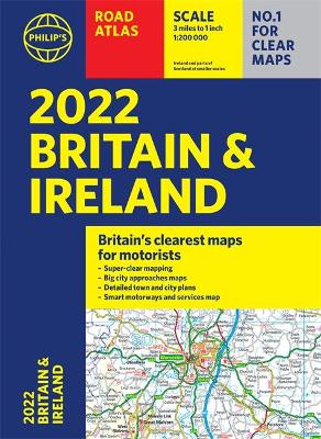
PHILIP`S – THE FASTEST GROWING BRAND OF UK ROAD ATLASES No. 1 in the UK for clear maps `Good balance between detail and clarity with excellent town maps` What Car? Mapping at a scale of 3 miles to 1 inch = 1:200,000 Philip`s: Britain`s clearest maps for motoristsCompletely updated and revised for 2022New map showing Smart Motorways – 160 pages of fully updated super-clear road maps – 10 pages of detailed route-planning maps – plan your route in advance – 88 indexed town-centre maps – 14 pages of city approach maps with named arterial roads – 2 page road map of Ireland- Map of scenic Britain and a map highlighting railways, airports and ferry ports Philip`s 2022 Road Atlas Britain and Ireland is the top-of-the-range paperback road atlas featuring the latest maps from the Philip`s digital database. Voted Britain`s clearest and most detailed in an independent consumer survey, the mapping is super-clear. Philip`s 2022 Road Atlas Britain and Ireland contains 160 pages of road maps covering Britain at 3 miles to 1 inch, with the Western Isles, Orkney and Shetland at smaller scales. The maps clearly mark service areas, roundabouts and multi-level junctions, and in rural areas distinguish between roads over and under 4 metres wide. The atlas also includes a 2-page road map of Ireland, 10 pages of route-planning maps, a distance table, 10 large-scale city approach maps with named arterial roads, and 88 extra-detailed and fully indexed town and city plans.

Related Products:
 Britain & Ireland Philip`s Big Road Atlas 2022 A3 PAPERBACK
 Britain & Ireland Philip`s Essential Road Atlas 2021 A4 PAPERBACK
 Britain & Ireland Philip`s Big Road Atlas 2021 A3 PAPERBACK
 Britain & Ireland Philip`s Motorist`s Road Atlas 2019 A3 PAPERBACK
 Britain & Ireland Philip`s Road Atlas 2022 A4 SPIRAL-BOUND
 Britain & Ireland Philip`s Big Road Atlas 2022 A3 SPRIAL-BOUND
 Britain & Ireland Philip`s Complete Road Atlas 2020 SPIRAL-BOUND
 Britain & Ireland Philip`s Complete Road Atlas 2020 HARDBACK
 Britain Philip`s Easy to Read Road Atlas 2022 A4 PAPERBACK
 Britain & Ireland Philip`s Handy Road Atlas A5 SPIRAL-BOUND
 Great Britain & Northern Ireland A-Z Road Atlas 2022 A3 PAPERBACK
 Britain and Northern Ireland Collins Big Road Atlas 2022 A3 PAPERBACK
 Britain Philip`s Driver`s Road Atlas A4 PAPERBACK
 Britain Philip`s Big Easy to Read Road Atlas 2022 A3 SPIRAL-BOUND
 Great Britain & Northern Ireland A-Z Road Atlas 2021 A3 PAPERBACK
 Britain and Ireland Collins Handy Road Atlas 2022 A5 SPIRAL-BOUND
 Great Britain & Northern Ireland A-Z Road Atlas 2023 A3 PAPERBACK
 Britain Philip`s Navigator Road Atlas FLEXI-BOUND
 Britain Philip`s Navigator Road Atlas SPIRAL-BOUND
 Britain Philip`s Navigator Trucker`s Road Atlas A3 SPIRAL-BOUND
 Britain Philip`s Compact Road Atlas A5 FLEXIBOUND
 Britain Philip`s Navigator Camping and Caravanning Road Atlas
 Britain Philip`s Navigator Easy-Use Road Atlas
 Britain and Northern Ireland Collins Big Road Atlas 2021 A3 PAPERBACK
 Britain and Ireland Collins Handy Road Atlas 2021 A5 SPIRAL-BOUND
Britain and Northern Ireland Collins Essential Road Atlas 2022 A4 SPIRAL-BOUND
Britain and Northern Ireland Collins Big Road Atlas 2023 A3 PAPERBACK
Britain and Ireland Collins Handy Road Atlas 2021 A5 SPIRAL-BOUND
Britain and Northern Ireland Collins Essential Road Atlas 2022 A4 SPIRAL-BOUND
Britain and Northern Ireland Collins Big Road Atlas 2023 A3 PAPERBACK
 Great Britain & Northern Ireland A-Z Super Scale Road Atlas 2022 A3 SPIRAL-BOUND
 Britain & Ireland Philip`s Big Road Atlas 2017
 Britain and Northern Ireland Collins Big Road Atlas 2022 A3 SPIRAL-BOUND
Britain and Ireland Collins Handy Road Atlas 2023 A5 SPIRAL-BOUND
Britain and Northern Ireland Collins Big Road Atlas 2022 A3 SPIRAL-BOUND
Britain and Ireland Collins Handy Road Atlas 2023 A5 SPIRAL-BOUND
 Europe Philip`s Big Road Atlas 2021 A3
 Britain & Ireland Philip`s Complete Road Atlas 2017 SPIRAL-BOUND
 Europe Philip`s Complete Road Atlas 2020
 France Philip`s Navigator Road Atlas SPIRAL-BOUND
 Britain and Northern Ireland Collins Essential Road Atlas 2021
 Europe Philip`s Multiscale Road Atlas 2021 A4 FLEXIBACK
 France & Spain Philip`s Road Atlas
 Great Britain A-Z Road Atlas 2022 A4 SPIRAL-BOUND
 Europe Philip`s Multiscale Road Atlas 2020 A4